


Sept 2, 2024 Monday Tropical Update
Atlantic disturbance fizzles, another week of quiet

Thank you to Subscribers and Supporters into Year 2 of this newsletter. For my maps users, this is Year 8 of Weather Models, and 22 years since starting grad school at Florida State.
This is a free post. Please consider subscribing to receive all daily updates for the next year (10% off promotion) to support this newsletter and my time/efforts with weather model analysis and development.
Happy Labor Day and the unofficial end to summer. Temperatures were 1.74°F above the last 30-years climatology across the Lower 48. The western half of the country was quite warm especially California, Nevada, and Arizona. The corn belt was near average.

Summer precipitation is highly convective during the summer but patterns do emerge over a 3-month period. The heavy rain with Hurricanes Beryl and Debby really did damage to the +anomaly across Texas around Houston and from Florida into the Carolinas.
The dry areas centered just along and west of the Appalachians from the Ohio Valley to Gulf Coast including Nashville missing over 6-inches compared to the 30-year normal.

Deficits continue across much of the Lower 48 over the next 10-days as a dry Canadian air mass pushes southward against the summer tropical moisture flow across Texas, Gulf Coast and into Florida.

Noon Temperatures

Very comfortable temperatures across much of the Lower 48 during the Noon hour with 60s and 70s covering much of the northern 2/3 of the country. Still 80s and 90s in the Southeast but rainfall later today will cool down many folks. Texas is currently being soaked and the 90s and 100s are long gone. Might not see too many more 90 degree days in Dallas or Houston until later in September after this pattern shifts.
High Temperatures on Monday
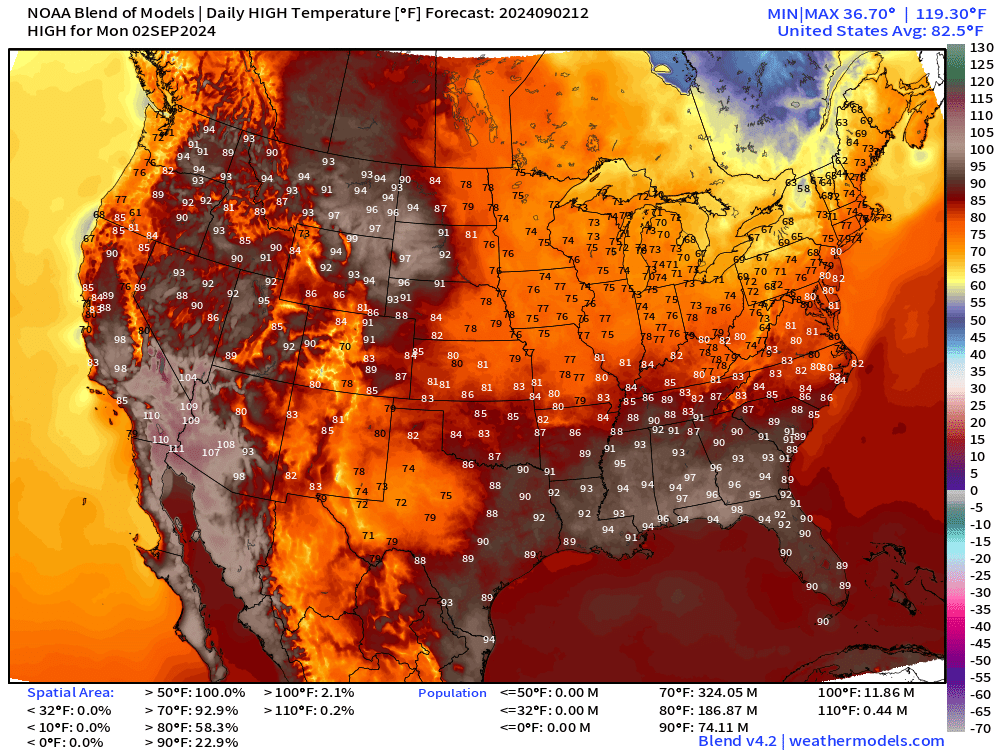
Only 74 million reach 90°F today. Very comfortable 70s across the Great Lakes and New England. Might be a bit chilly for the beach, but a nice afternoon outside is guaranteed.
Low Temperatures on Tuesday

You can see some 20s and 30s popping up in northern New England and Quebec.
Cool in the 40s and 50s from the central Plains into the Great Lakes, Ohio Valley and Northeast. Very comfortable — windows open.
Rainfall Chances This Afternoon

The cold front is making good progress southward and only 30% chance of rain in Atlanta this afternoon. Better chances in Texas with ongoing heavy showers and central Florida where tropical moisture will remain for many weeks to come.

Atlantic Tropics Slumber as African Waves Head WNW
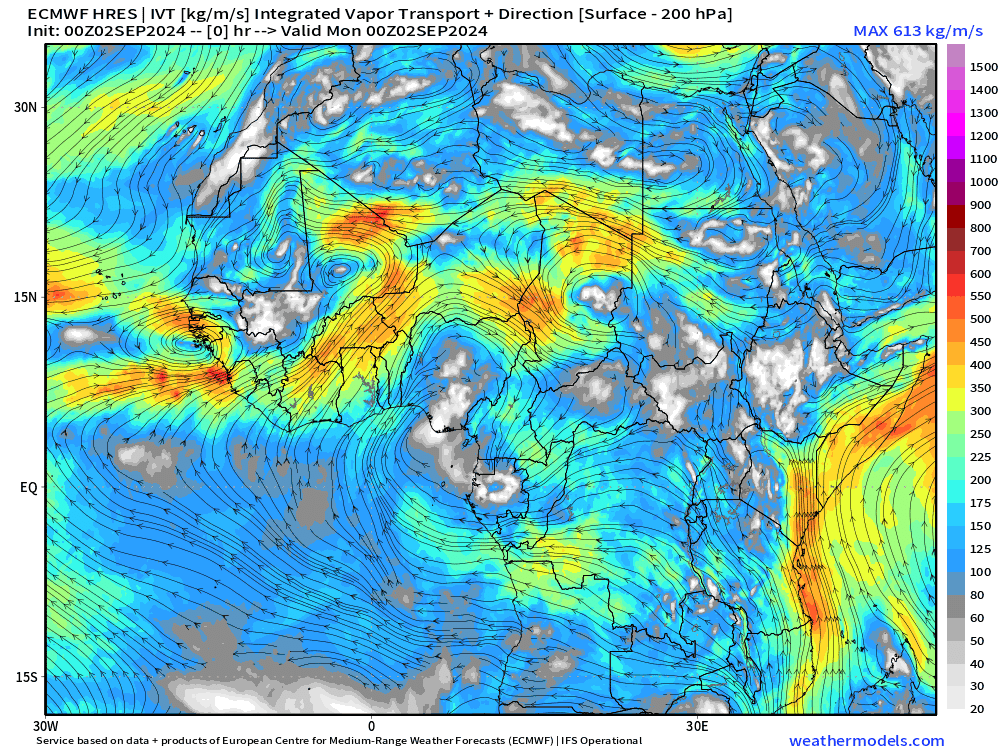
Looking ahead into the next 10-days across the Atlantic for tropical waves coming off the African continent. The situation is bizarre as the waves take on a WNW track and emerge heading over the cooler Canary Current. The origin of the waves at 15°N over central Africa is a reflection of the northward shift of the ITCZ / monsoon trough over Africa providing significant rainfall to the Sahel. September 2024 looks to be a continuation of the past several weeks over the tropical Atlantic with quiet conditions.
Atlantic IR Satellite

The area of disturbed weather that we watched for the past several days in the Atlantic east of the Lesser Antilles has moved into the eastern Caribbean. No development is expected for another few days — and then only at 40% — with potential for spin-up near the Yucatan or the southern Gulf of Mexico.
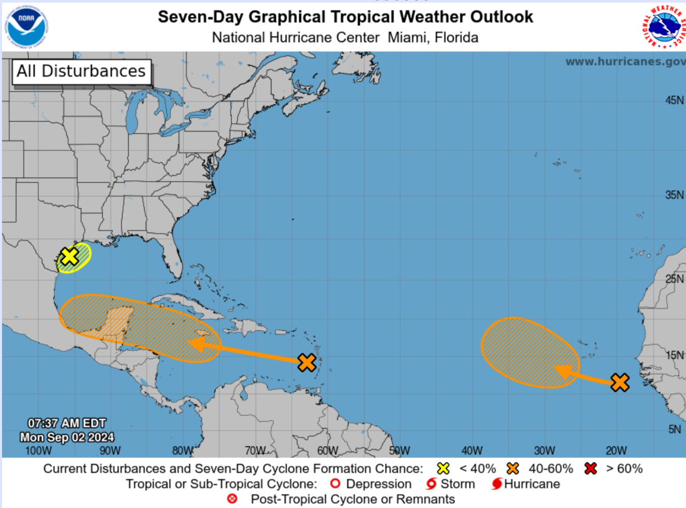
The yellow X off Texas is unlikely to become a named system but will dump heavy rain along the coast.
One more region west of Cape Verde Islands is being watched for development (40%) but it would head WNW and then NW not affecting land. I think that’s our best chance of Francine.
Next 10-days Upper Level Pattern

The main story for the Lower 48 is the much cooler weather with a very strong trough digging into the Great Lakes and then eastern U.S. into this next weekend. Then, another trough for the Pacific Northwest. The pattern remains quite fall like with plenty of shortwaves and disturbances.
GFS 12z No Tropical Development through 14-days

Next 5-day and 8 day ECMWF EPS Tracks

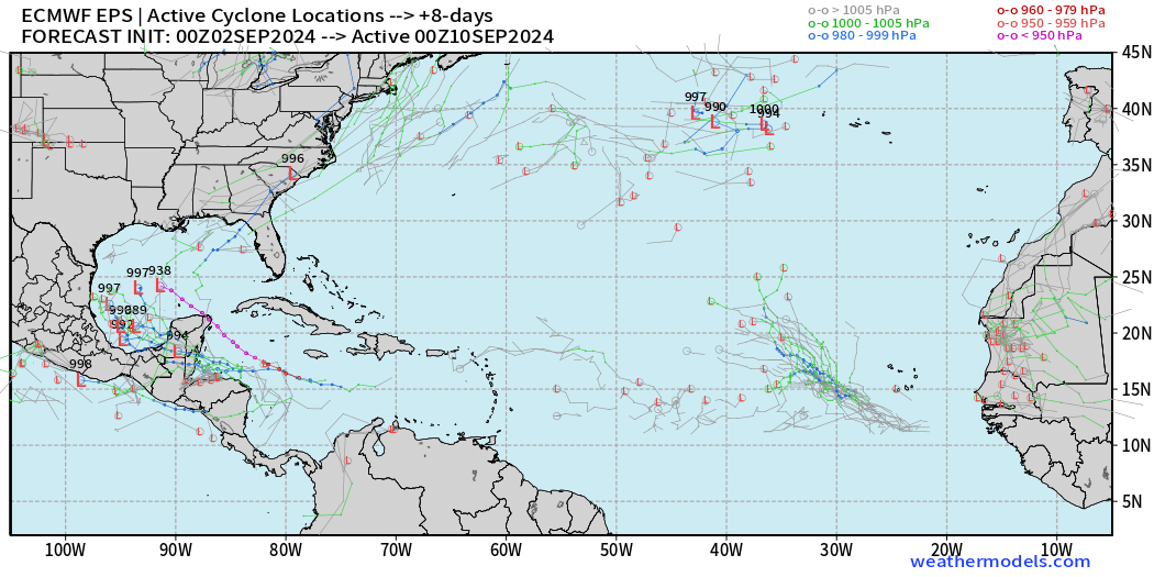
September 7 — 5 days active tracks: 2 members (4%) show a hurricane in the Caribbean.
September 10 — 8 days active tracks: Quite a few more members with a named storm in the southern Gulf of Mexico. However, we’re talking about 10-20% chance.
Monday Summary: 10% chance of development of tropical wave in the Caribbean over the next few days. Maybe 20% thereafter in the southern Gulf of Mexico.
This is by far one of the most spectacular model forecasting busts ever for tropical cyclone genesis east of the Lesser Antilles. I am not complaining about the outcome, but our inability to forecast tropical cyclogenesis out of Atlantic monsoon trough is quite concerning. We have much work to do to understand what/why went wrong.
Western Pacific Typhoon Outlook
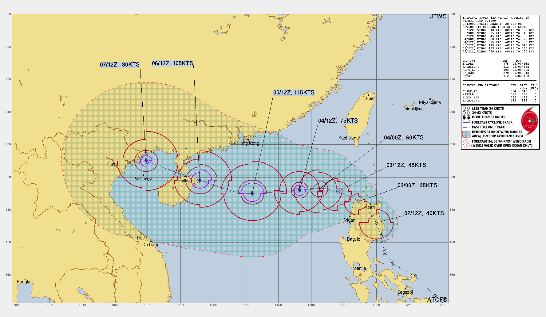

Tropical Storm Yagi will become a Typhoon — perhaps up to 115-knots — over the South China Sea
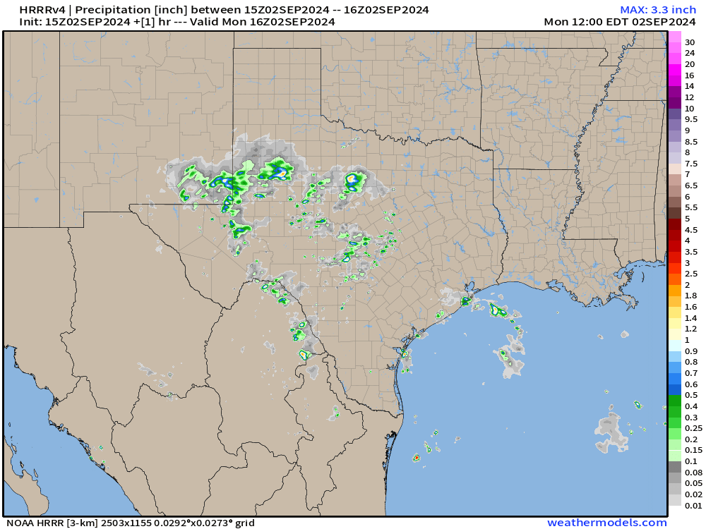
Forecast Precipitation: Next 36-hours

Texas rainfall looks bountiful!
HRRR simulation of precipitation into early Tuesday morning.
Total Rainfall next 7-Days | NOAA WPC

Plenty of southeast U.S. rainfall over the next week as the frontal boundary + trough remains focus of unsettled weather. No complaints — much cooler with cloud cover.
EPS Weekly Temperature Anomaly
Week 1: September 2-8

Eastern U.S. overall is much below normal for the next week
Week 2: September 9-15
Cooler conditions continue into mid-September across the large population of eastern Lower 48 from Texas into NYC.

Thank you to Subscribers and Supporters!
Maps sourced from weathermodels.com designed and innovated by yours truly! I actually create all of my content from scratch.
Thank you for this excellent summary of the north American weather.
If only the MSM would cease and desist from their scaremongering support of all those pessimistic Climate Alarmists doomster utterances that spread nothing but anxiety and fear, and have a shortened weekly synopsis taken from data such as this,.
And this has to happen before we might be able to return to some sensibility in all this divisive, fearmongering propaganda concerning the fluctuations in the weather of the planet whose climate does indeed change and has done so over millennia, al-be-it in a normal and unpredictable but cyclical pattern.
I have a mid-sept conference in Orlando so I’m hoping the North Atlantic stays quiet