


September 13, 2023 Hurricane Season
Hurricane Lee to lash coastal New England on Saturday
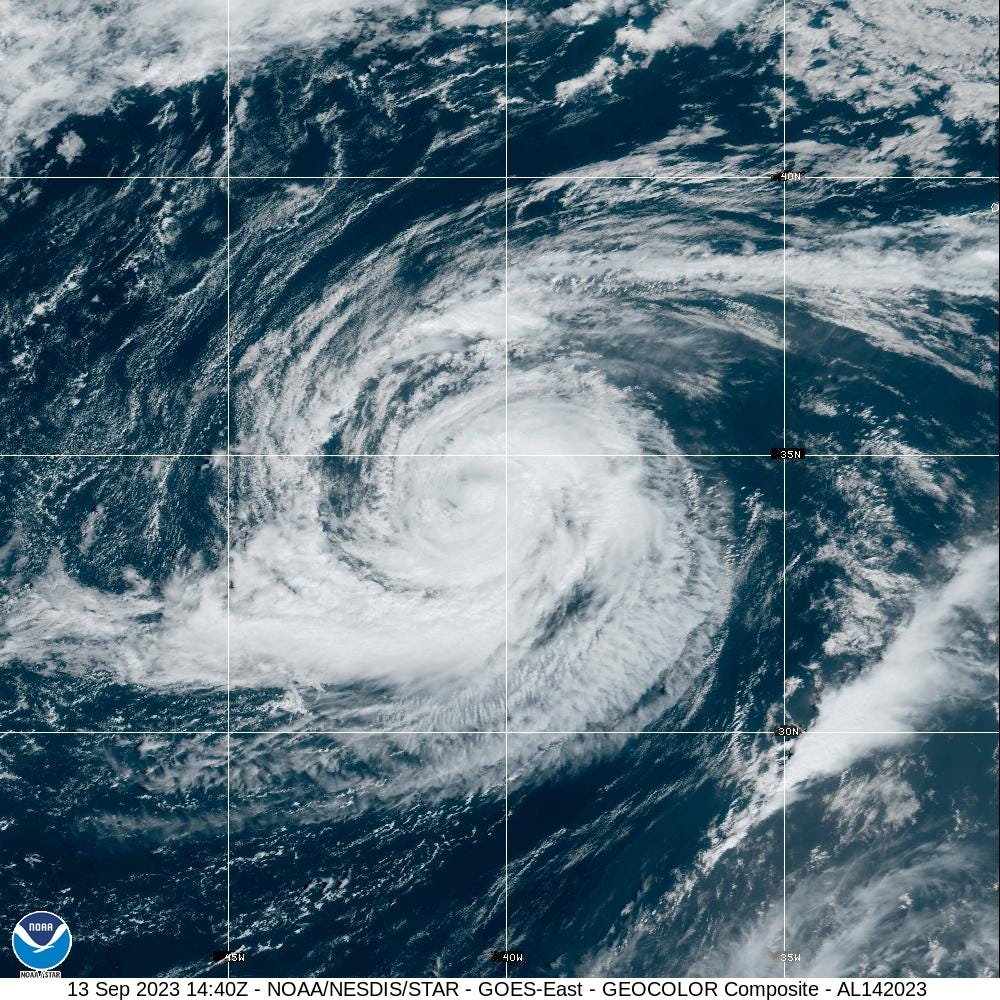
Hurricane Lee is still a major hurricane (100-knots) and expanding in size as it now moves north. The inner-core is still intact but cooler water, wind shear, and dry air will eventually obliterate it. However, until that happens, Lee should maintain central pressure ~950 mb. By Saturday morning, Lee will reach the latitude of Cape Cod and slightly jog westward into the Gulf of Maine as a trough grasps hold of the storm.
The most severe impacts will be along the coast: winds up to hurricane force gusts, coastal erosion and heavy rain. With the recent flooding in New England, strong winds out of the North could contribute to tree damage. Lee will probably become post-tropical or complete extratropical transition prior to landfall in far eastern Maine or New Brunswick.
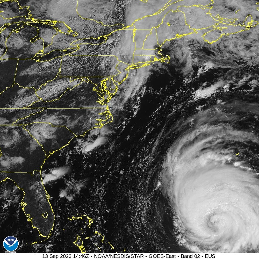
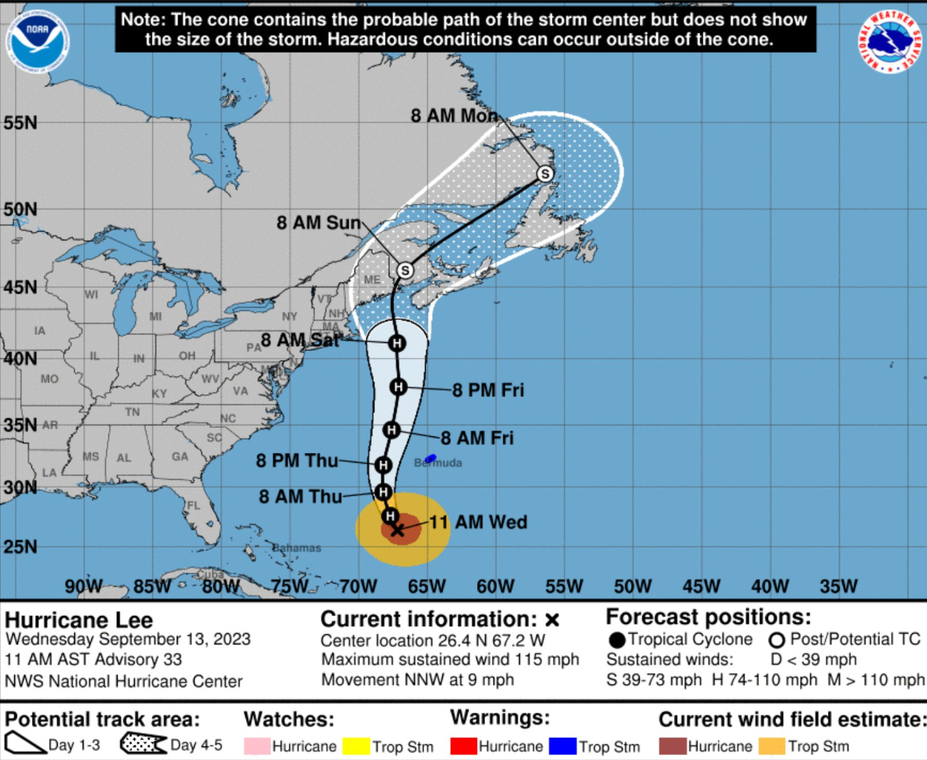
The NHC 11 AM track update shows the slight westward wobble after 8 AM Saturday. However, the enormous size of Lee makes the landfall location less relevant for impacts. The movement will be rather slow — note it takes 24-hours to travel 5° of latitude. That’s a long duration tropical storm / near hurricane / Nor’easter event for coastal New England.
Impacts to the Northeast U.S. from Lee: Saturday and Sunday
No change to previous guidance: the track of Lee is due north until about 40°N latitude when a trough interaction could pull it toward the Maine coast slightly before landfalling into Nova Scotia. However, the large size of Lee makes the actual center location less important especially since the worst weather will be on the back-side of storm as it undergoes extratropical transition.
The main threats are enormous waves and gusty winds over a very large area around Lee — somewhat dependent upon the track of the low pressure center. Lee will have 70-80 mph wind gusts surrounding the storm center out to 100-200 miles in all directions, according to GFS 06z. Over land, these gusts would be significantly reduced, and New England should be prepared for 40-60 mph gusts, higher along the coast.


2023 Medium Range Atlantic Tropics
Still watching Invest 97L to become Nigel in the next several days. NHC chance of development is up to 80% in next 2-7 days.


The spaghetti from the global and mesoscale models is clustered tightly on a WNW to NW track to near Bermuda in 7-10 days. Amazingly the ECMWF HRES 00z at Day 2 and Day 10 almost match with Lee and Nigel occupying the same real estate. Expectation would be recurve track of Nigel but obviously can’t discount what we just saw with Lee.


Hurricane Margot peaked at 80-knots and will do a slow loop before weakening. No threat to land.
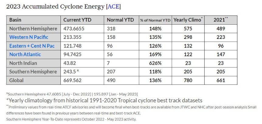
Atlantic 2023 Year to Date | ACE: 95 (169% normal | 56)
Unnamed Subtropical Storm [January 2023]
Arlene 02L: 35 knots, Bret 03L: 60 knots, Cindy 04L: 50 knots
Don 05L: 65 knots, Emily 07L: 45 knots, Franklin 08L: 130 knots
Gert 06L: 40+ knots, Harold 09L: 45-knots, Idalia: 115-knots
Jose: 50-knots, Katia: 50-knots, Lee: 145-knots
Margot: forecast hurricane, Nigel: next up this week
2023 Eastern Pacific Hurricane Season
Invest 94E has popped up in the Eastern Pacific and has a good chance (60%) of developing into a weak, short-lived storm. The next name is Kenneth.

Adrian 01E: 90 knots, Beatriz 02E: 75 knots, Calvin 03E: 110 knots
Four 04E: 30 knots, Dora 05E: 125 knots, Eugene 06E: 60 knots
Fernanda 07E: 115 knots, Greg 08E: 45 knots
Hilary 09E: 125 knots, Irwin 10E: 40 knots, Jova: 140 knots
2023 Western Pacific Typhoon Season
Quiet.
Sanvu 01W: 30 knots, Mawar 02W: 160 knots, Guchol 03W: 90 knots
Talim 04W: 85 knots, Doksuri 05W: 130 knots, Khanun 06W: 120 knots
Lan 07W: 115 knots, Damrey 08W: 65 knots, Saola 09W: 135 knots
Haikui 10W: 105 knots, Kirogi 11W: 60 knots, Yun-Yeung 12W: 40-knots
Thank you for subscribing! Your support pays for my servers and product development. Feel free to say hello and follow on Twitter (@RyanMaue)
I've been watching tropical waves come off Africa and form tropical storms. The waves seem to come from the Indian ocean and travel across Africa. Has anyone tried to correlate the Indian Ocean Dipole with Atlantic tropical storms?