


September 10, 2023 Hurricane Season
Hurricane Lee rapidly weakened temporarily
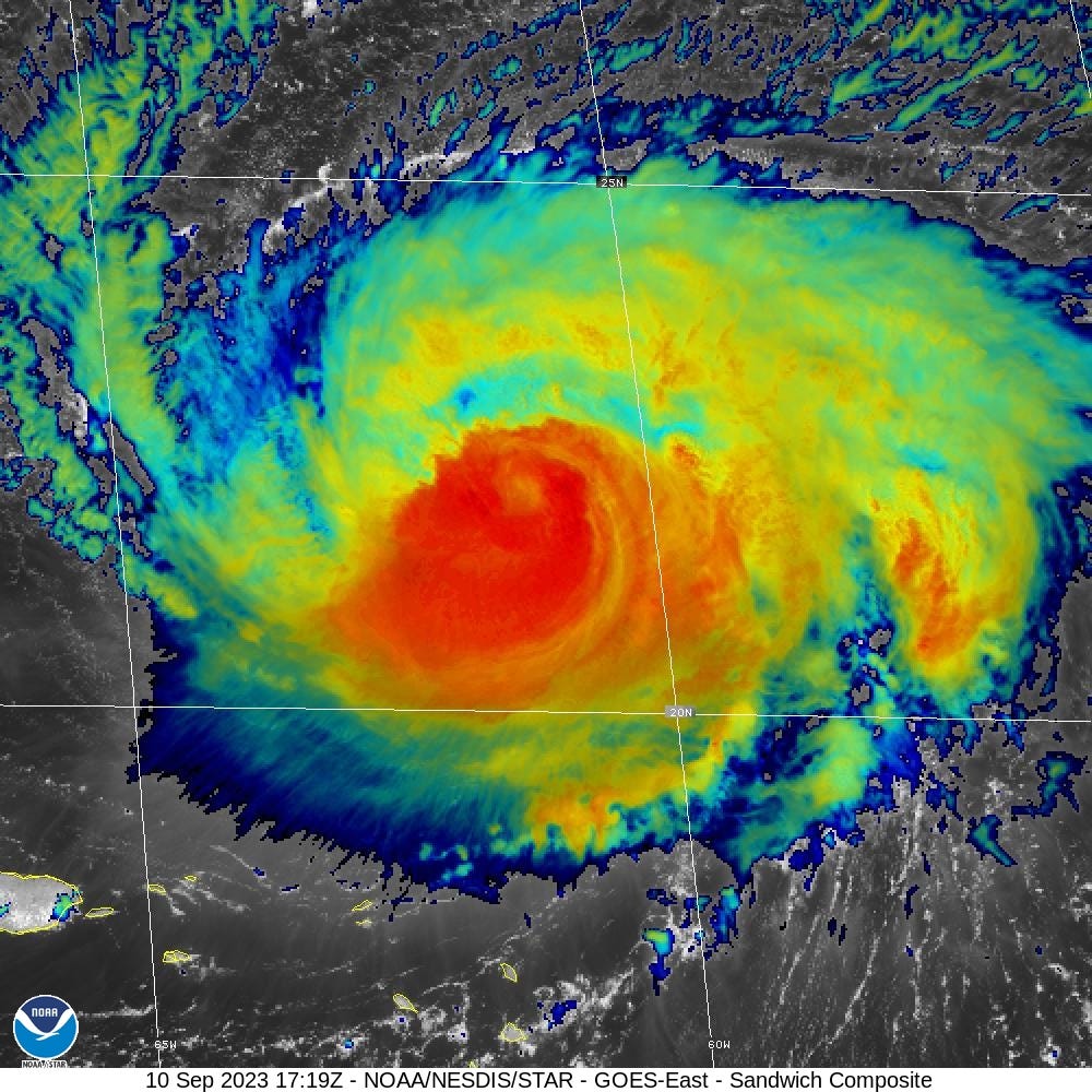
Hurricane Lee was severely disrupted by wind shear over the past couple days and weakened dramatically to 90-knots (Category 2) at 06z and slightly recovered to 95-knots at 12z, also the 11 AM ET NHC intensity. Intensification appears likely as satellite presentation has improved considerably with convection wrapping around the eye and symmetric cloud canopy expanding in all quadrants.
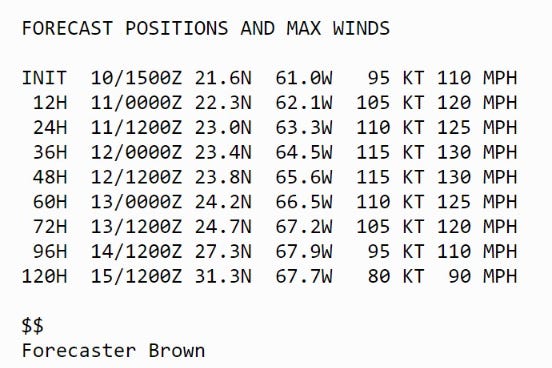
The maximum forecast intensity is 115-knots (Category 4) but that could be conservative if another possible rapid intensification episode occurs.
At what longitude will Hurricane Lee reach 25°N? The NHC 11 AM forecast is east of 68°W.
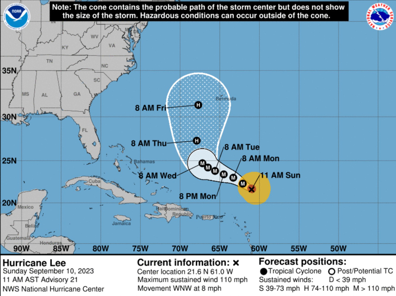
Note that Bermuda is in the right edge of the cone at day 5, but impacts including tropical storm force winds are expected since Lee will be enormous by middle of coming week. There is no direct threat to Florida, the Carolinas or DelMarVa from Hurricane Lee. However, huge coastal waves, swell, and dangerous rip currents. The maximum wave size from the ECMWF model is up to 80-feet around Bermuda on the eastern half of Lee. Really enormous waves. U.S. East Coast waves look to be 10-15 feet (significant) and double that for maximum height just offshore.


The most recent 12z GFS has shifted slightly west with landfall in Nova Scotia in 7-days (168-hours). Can’t stress enough about how large Lee will be with its wind field. We’re talking about hurricane force wind gusts hundreds of miles away from the center. While the center may remain well offshore from Cape Code and New England, that does not remove the risk of hurricane conditions next Sun/Mon.


00Z ECMWF HRES was slower with landfall at Day 8. There is uncertainty in both the along and cross track ensemble members. The HRES is consistent with the Ensemble Mean after being an outlier yesterday at 12z that frightened social media users.


The rest of the global and mesoscale guidance is all tightly clustered, so we can safely ignore western outliers of the ensembles unless/until we see the other models jump westward. The cake is mostly baked. We’re still another 48-hours before the cone beings to encompass the Northeast U.S. as NHC drops track points, but hopefully there are no surprises.

2023 Medium Range Atlantic Tropics
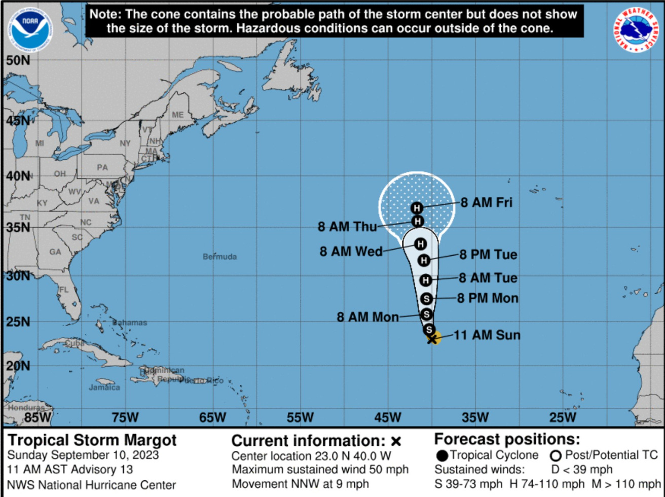
Tropical Storm Margo 14L continues to slowly organize along 40°W longitude well away from any land. The intensity maximum is 70-75 knots (Category 1) over next 5-days as it gains latitude. Then, Margot could slow down and meander with one ensemble cluster sending the system ESE with the rest northward. The potential impact to Lee’s track seems to have been resolved by the models.

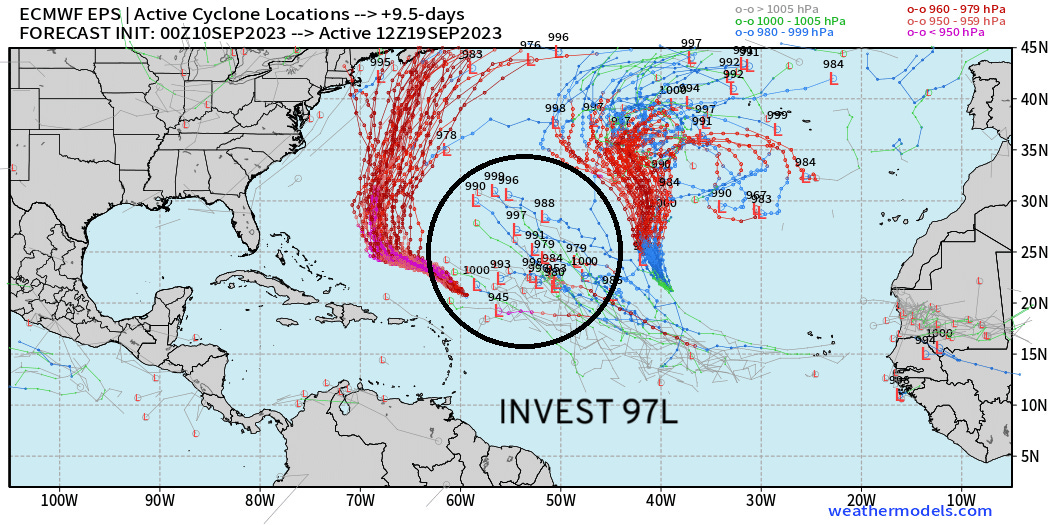
NHC has highlighted Invest 97L well out in the Atlantic with a 40% chance of development in 7-days. Too soon to say anything about land impacts, which would be 10-14 days away, minimum.
Atlantic 2023 Year to Date | ACE: 77 (154% normal | 50)
Unnamed Subtropical Storm [January 2023]
Arlene 02L: 35 knots, Bret 03L: 60 knots, Cindy 04L: 50 knots
Don 05L: 65 knots, Emily 07L: 45 knots, Franklin 08L: 130 knots
Gert 06L: 40+ knots, Harold 09L: 45-knots, Idalia: 115-knots
Jose: 50-knots, Katia: 50-knots, Lee: 145-knots
Margot: forecast hurricane
2023 Eastern Pacific Hurricane Season
Tropical Storm Jova has almost dissipated into a remnant low, however it’s waves and swell continue to bombard the U.S. West Coast. Surf’s up!
Eastern Pacific 2023 | Year to Date ACE 122 (135% of normal | 90)
Adrian 01E: 90 knots, Beatriz 02E: 75 knots, Calvin 03E: 110 knots
Four 04E: 30 knots, Dora 05E: 125 knots, Eugene 06E: 60 knots
Fernanda 07E: 115 knots, Greg 08E: 45 knots
Hilary 09E: 125 knots, Irwin 10E: 40 knots, Jova: 140 knots
2023 Western Pacific Typhoon Season
Quiet.
Western Pacific Typhoon 2023 YTD ACE: 213 (140% normal | 152)
Sanvu 01W: 30 knots, Mawar 02W: 160 knots, Guchol 03W: 90 knots
Talim 04W: 85 knots, Doksuri 05W: 130 knots, Khanun 06W: 120 knots
Lan 07W: 115 knots, Damrey 08W: 65 knots, Saola 09W: 135 knots
Haikui 10W: 105 knots, Kirogi 11W: 60 knots, Yun-Yeung 12W: 40-knots
Thank you for subscribing! Your support pays for my servers and product development. Feel free to say hello and follow on Twitter (@RyanMaue)