


Sept 16, 2024 Monday Tropical Update
Watching Caribbean way down the road

We did not get Tropical Storm Helene from the disturbance that moved into North Carolina this afternoon. Very heavy rain did fall, which was the advertised primary threat. However, NHC did go with the Potential Tropical Cyclone 08L labeling and that provided Tropical Storm warnings to the coast hopefully helping with emergency preparations.
Tropical Depression Gordon (07L) is holding on in the central Atlantic but not generating any ACE.
Accumulated Cyclone Energy (ACE) is pretty simple: it’s the square of the wind speed (knots) every 6-hours divided by 10,000 to make the units manageable.
So, a 65-knot hurricane for one day would = 65*65*4 / 10000 = 1.69 units of ACE.
The 1991-2020 yearly climatology is about 122 in the North Atlantic. We are at 64 and the normal YTD is 64. We are average for ACE on the 7 named storms this season now more than half way through.
1995-2024 would be the optimal climatology (30-years) into the most recent “active period” so we’ll do that next year. ACE chart from my Climate Atlas website.
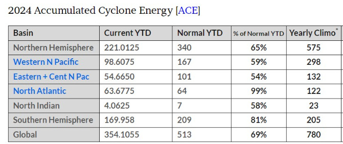
Note that the Eastern and Western Pacific are also roughly half of normal ACE for the YTD. The Northern Hemisphere as a whole is 35% below normal.
With the very warm (boiling) oceans, you’d think the Earth would create more tropical storms and blow them up into major hurricanes. Not so much.
Next 10-Days Atlantic Integrated Vapor Transport

The Caribbean Gyre is back in business in the 7-10 day range. We’ll see if the broad cyclonic circulation can spawn 1-2 storms perhaps on the Eastern Pacific side of Central America as well.
Keep reading with a 7-day free trial
Subscribe to Weather Trader to keep reading this post and get 7 days of free access to the full post archives.