


October 30, 2023 Afternoon Update
Arctic chill sweeps across the Lower 48
The intensity and scale of the Arctic cold is impressive for late October. I underestimated the historical context of the cold e.g. high temperatures in the mid-40s in Texas is about as cold as it can get going back through 150-years of records. Temperature anomalies are up to 35°F below normal into Mexico. The cold front is slowly inching eastward wiping away all the wonderful, hard earned sunshine and 80°F heat from Atlanta, Charlotte, and up to D.C.
The overall Lower 48 temperature anomaly is -12°F for mid-afternoon.


Of course, this is caused by our friendly Polar Vortex. Looking at the “dynamic tropopause” level, we see a gray fuzzball or cold anomaly in the potential temperature field indicating very cold air aloft and a much depressed or lowered in altitude tropopause centered over Michigan. This is very impressive for late-October, and if translated to January, would be a crippling cold Arctic blast.
Does this mean the El Niño will bring more of these “wave breaking” episodes with the polar vortex sending lobes to swing through like a pendulum? That’s a good question, no idea. But, there is some literature that suggests El Niño favors a higher frequency of wave breaking in the subtropics that would be more cut-off lows especially in the Southeast US.

Looking at the 500 mb height anomaly shows quite the trough over the Great Lakes Tuesday afternoon. This is heavy duty stuff. Thankfully, warmer flow from the Pacific blasts across the Lower 48 and traps the the rest of the tropospheric Polar Vortex over Hudson Bay — bottling it up for at least another week.

Great Lakes Snowfall
Heaviest snow off of Lake Superior in the Upper Peninsula of Michigan with lighter amounts or just flurries inland from Lake Michigan. A disturbance associated with the polar vortex lobe will drop a few inches across Minnesota and Wisconsin.
I remember one Halloween in Northern Michigan when I was a kid and it was too cold and snowy to go trick-or-treating.


Colorado Snowfall
Snowfall over the past few days across Colorado was substantial including a general 6-12” across the foothills with 3-feet in the highest elevations. Quite the starting bid for winter in the Rockies. Chilly temperatures will moderate into mid-week into the 60s in Denver.

10-Day GFS and ECMWF snowfall forecasts
The next major threat for snowfall seems to be in the 7-10 day range in the Great Lakes and Northeast from both ECMWF and GFS. Nothing imminent as temperatures moderate from coast to coast after this Arctic blast departs.


2023 Atlantic Hurricane Season | Medium Range Outlook
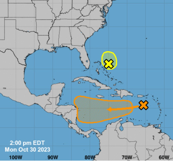
NHC is watching the SW Caribbean for a disturbance that could briefly become a Tropical Depression or a Tropical Storm in the next few days [60% chance] before crossing into Nicaragua. The next name is Vince. Unlikely to see development east of the Bahamas (10%).

2023 Eastern Pacific Hurricane Season
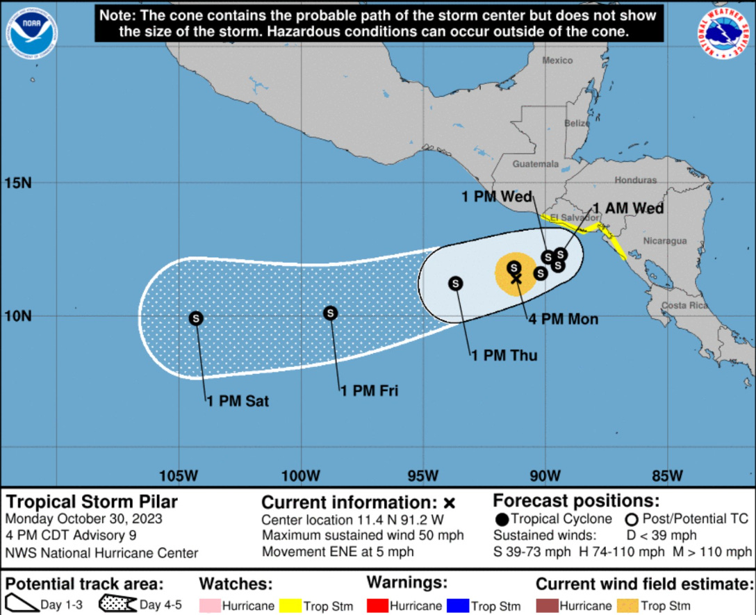
Tropical Storm Pilar is meandering off the coast of El Salvador with 50 mph winds. It could strengthen into a minimal hurricane and drop considerable rainfall, but then head westward into the weekend.
2023 Western Pacific Typhoon Season
Small chance of development in next 7-days or so east of the Philippines with Invest 92W.
2023 North Indian Ocean Cyclone Season
Quiet for the next 7-days
2023-24 South Pacific Cyclone Season
Quiet for next 7-days
Thank you to my paying subscribers! Your support pays for my servers and product development. Feel free to say hello and follow on Twitter (@RyanMaue)