


October 20, 2023 Afternoon Update
Tammy now a hurricane
Hurricanes and Climate Change | Atlantic Basin ACE

Beginning a comprehensive research project on global hurricane activity. The Atlantic basin has a complete data record back to the 1940s when aircraft recon began with the Great Atlantic Hurricane of 1944 — which was actually upgraded from Category 4 to Category 5 in September 2022 as part of NOAA’s Hurricane Reanalysis project.
This work is partly motivated by a new journal article in Nature Scientific Reports published on Atlantic Hurricanes that huge media coverage. Here are the posts I wrote on Twitter/X here on the media coverage, most of which was bad. However, one article within Smithsonian Magazine was exceptional.
The easiest metric for Atlantic hurricane activity is Accumulated Cyclone Energy or ACE which is calculated by squaring the wind speed every 6-hours and summing up the result for each storm, month or season. Quick example: 100-knots x 4 six-hour “fixes” = 100*100*4 = 4 ACE units for a day of major hurricane intensity when divided by 10,000 to make the numbers manageable.
From the bar chart of ACE for the past 100-years, it’s apparent there are 2 active periods surrounding the inactive period of the 1970s until 1994.
The current active-period began in 1995 and has continued with many exceptional seasons including 1995, 2004, 2005 and 2017 with many major hurricanes with long lifecycles. From 1969-1994, there were comparatively much fewer major hurricanes. But, from 1926 until the mid-1960s, plenty of major hurricanes including devastating U.S. landfalls.
It should be clear that cherry-picking trends beginning in 1970 and neglecting valuable data in the 50-years prior is misleading. This was well understood in the so-called “Hurricane Wars” climate research papers of 2005-2007 after the incredibly busy 2005 season including Hurricane Katrina. In the last 15+ years, a consensus has formed that is nicely summarized on the NOAA GFDL Global Warming and Hurricanes page.
However, when you see a new research paper, especially with new metrics or percentages or ratios, and then overblown media coverage, the question arises whether the new findings are in accord with the current consensus. Are the results put into proper context? I think I have valuable insight into these matters as I’ve worked with the tropical cyclone datasets for almost 20-years now in a research capacity keeping track of global tropical cyclone activity since my days at Florida State. As the hurricane season winds down heading into winter, I’m planning on publishing at least 1-new article per week on climate change and hurricanes.
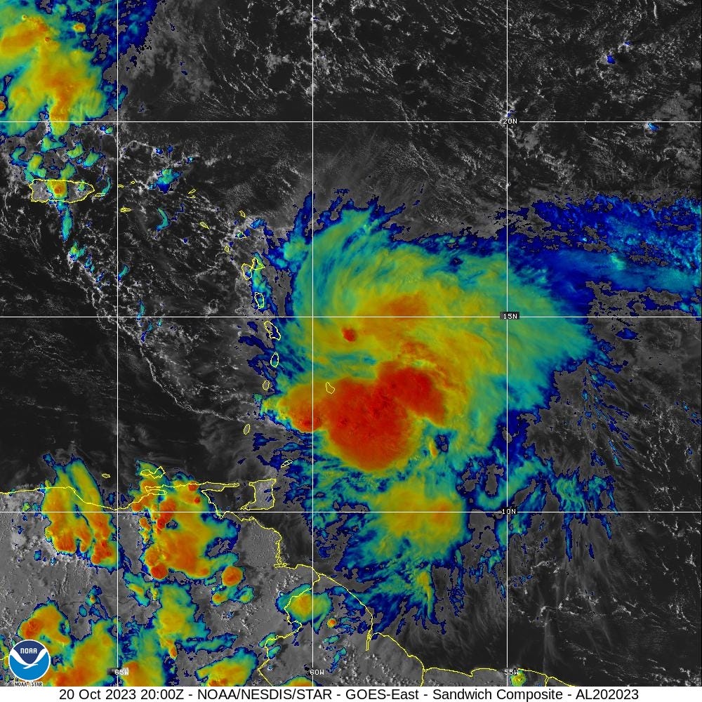
Hurricane Tammy
Tammy does not look very impressive on satellite imagery but aircraft recon found 75-mph winds and 991 mb central pressure — good enough for hurricane status. Warnings were issued across the islands. Forecast calls for 65-80 knots intensity for the next several days as Tammy moves into the open Atlantic. I wouldn’t be surprised if it finds a pocket of low wind shear and gets a kick from upper-level divergence ahead of a trough to become a major hurricane.


East Coast Storm this weekend
Temperatures are almost 11°F above normal across the Lower 48 with very warm 80s and 90s from the central Plains into Texas. The only cool spots are from Great Lakes into Ohio Valley and Carolinas due to cloud cover from our developing storm system that will wash out Saturday for the Northeast.


NWS NDFD forecast is for 0.5” to 1” of rain mainly on Saturday from NYC to Boston and then up to 2” northward into VT/NH and Maine. Sunday still looks good — chilly and breezy but dry from south to north with clearing.

Watching: Heavy rain threat for Texas and Oklahoma with moisture from Hurricane Norma next week, also extending northward into the Great Lakes.

Medium-range Snowfall Forecasts
Still watching next week for significant snowfall across the northern Rockies. ECMWF has backed off on amounts in the U.S. but plenty in Canada. GFS is going bonkers.


2023 Atlantic Hurricane Season | Medium Range Outlook
Aside from Hurricane Tammy, no other tropical cyclone formation is expected for the next 7 to 10-days+.
2023 Eastern Pacific Hurricane Season
Hurricane Norma (17E) is still a major hurricane.
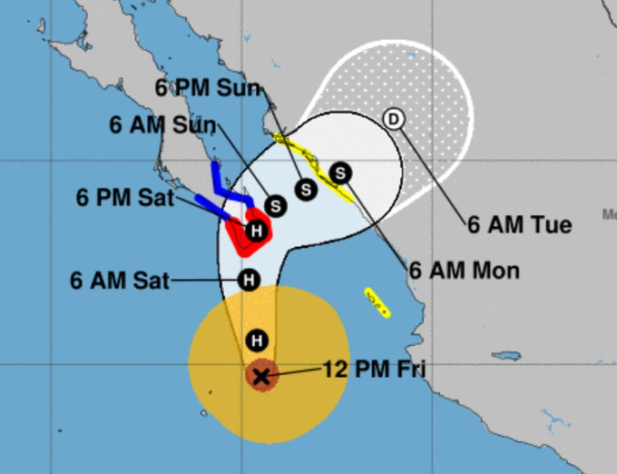
Hurricane warnings are up the tip of the Baja Peninsula as Norma approaches later on Saturday.
2023 Western Pacific Typhoon Season
Tropical Depression Sanba (16W) has weakened into a remnant low. Quiet in the Western Pacific for the next 5-7 days+
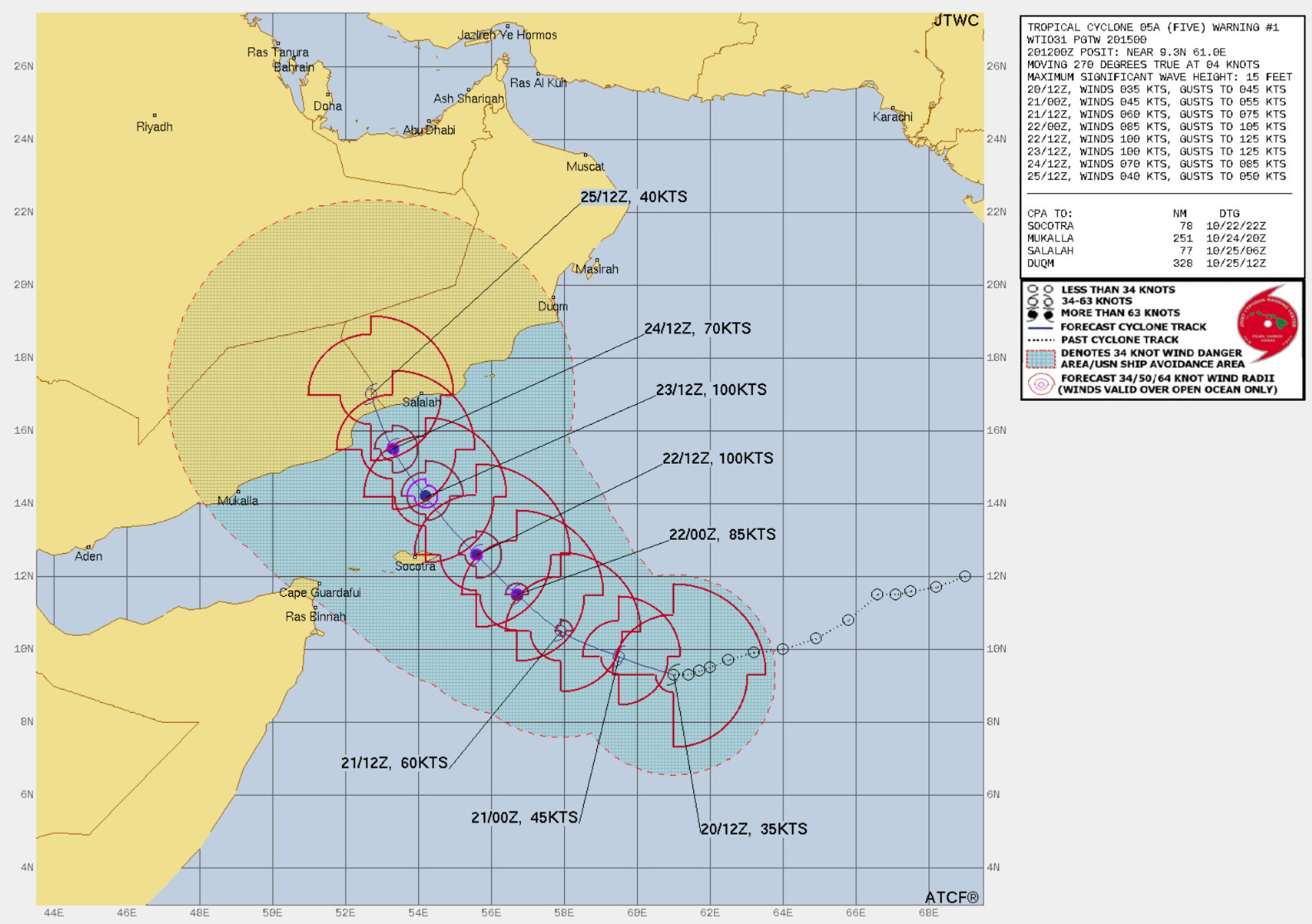
2023 North Indian Ocean Cyclone Season
Tropical Storm (05A) Tej has formed SE of the coasts of Oman/Yemen over the warm waters of the NW Indian Ocean. After monsoon season, usually in October-November, powerful tropical cyclones all the way up to Category 5 can form and move inland over the Arabian Peninsula usually at a much weaker intensity. Some storms also track into Pakistan or India on a more northerly course.
TS Tej is just now organizing but forecast by JTWC to reach 100-knots (Major/Category 3) and make landfall Mon/Tues next week at TS/H1.
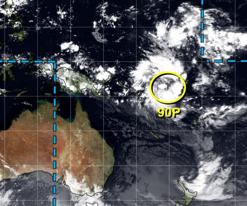
2023-24 South Pacific Cyclone Season
Watching an area of disturbed weather (Invest 90P) just south of the Equator that could develop into a powerful Tropical Cyclone in a few days.
Thank you to my paying subscribers! Your support pays for my servers and product development. Feel free to say hello and follow on Twitter (@RyanMaue)