


Oct 9, 2024 Wednesday Morning Hurricane Milton
Florida landfall in next 18-hours with destructive surge and winds

Weather Trader is a community supported daily+ newsletter to keep you updated on extreme weather around the U.S. and Earth. Yearly subs or upgrades can use this coupon for 20% off [through October 11].
Wednesday Morning Headlines
9 AM ET Hurricane Milton [14L] pressure 918 mb and winds 155 mph (135 knots) — Category 4.
Waypoint indicator for landfall — 25.3N 84.6W
Milton will slowly weaken in terms of maximum winds but continue to expand greatly in size — wind footprint, rainfall shield, and cloud-cover into Thursday morning.
Landfall intensity in terms of wind now 110-115 knots = right at edge of Category 4
Milton will expand as it moves NNE and then east along the Florida coastline before making landfall
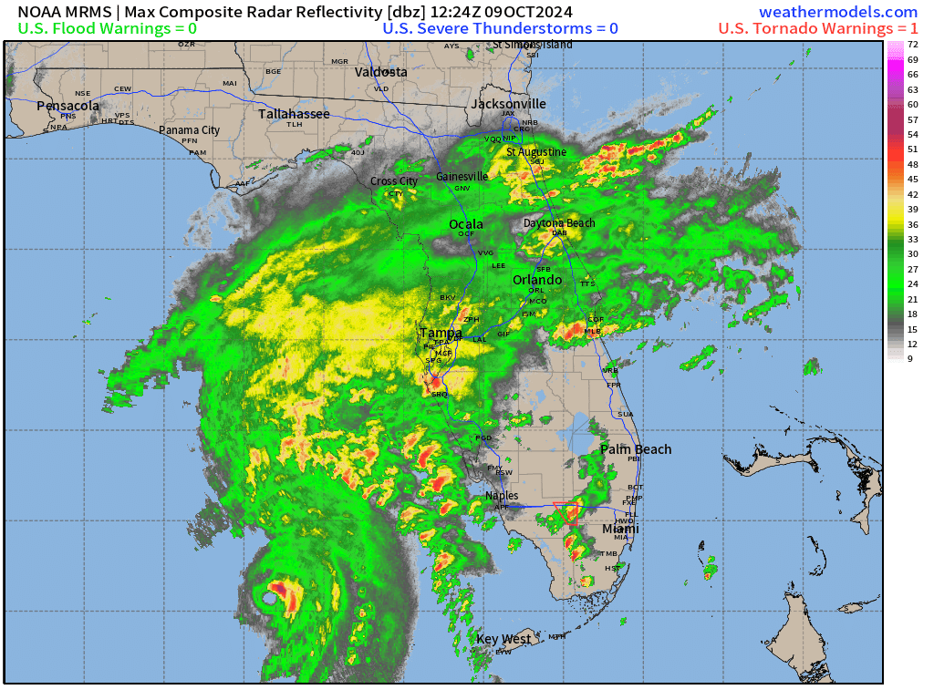
Hurricane Milton IR Satellite
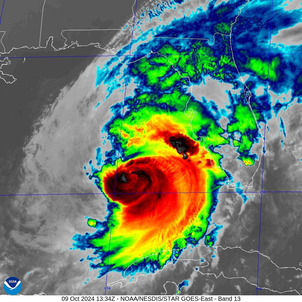
At 9:34 AM Hurricane Milton eye is gone on IR and appears to be rapidly degrading appearance with ragged cloud canopy eroded from the west by dry air. Don’t let that appearance fool anyone about the extreme (Category 5 accumulated) wind field and kinetic energy expanding 100s of miles.
8 AM Track of Milton | NHC Forecast
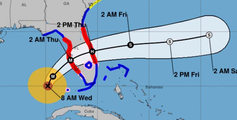
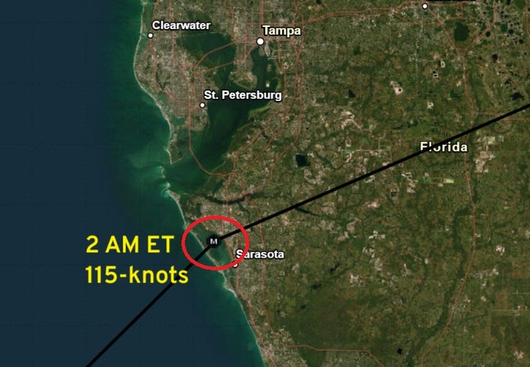
Bit slower progress of Milton as official landfall will be after 2 AM on Thursday as a Category 4 hurricane likely over Sarasota Bay — just south of Tampa Bay. However, the large size of Milton will mean impacts still spread over the entire Tampa Bay area and then across the Florida peninsula exiting the state around Melbourne. Orlando will be included in the risk area for Hurricane Force wind gusts.
After 2 pm on Thursday, the center of Milton will be exiting the Atlantic coast of Florida.
Intensity and Impacts of Milton
Wind shear will take its toll on Milton reducing the maximum wind speed / intensity through Category 4 … the initial condition here was 5 AM ET and Milton was 140-knots and Cat 5.
Note, Milton will maintain hurricane status across the entire Florida peninsula with powerful winds on the east Atlantic coast of Florida!
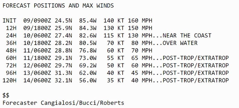
Landfall intensity: Category 3 110-knots and pressure in the mid-950s
Milton will remain a hurricane while crossing Florida and become extratropical possibly late Thursday.
Storm Surge Impacts
Maximum storm surge of 8-12 feet in Tampa Bay slightly down from 10-15 feet from previous forecasts. However, the much higher surge of up to 15-feet extends south to Boca Grande.
Wind Gusts Impacts
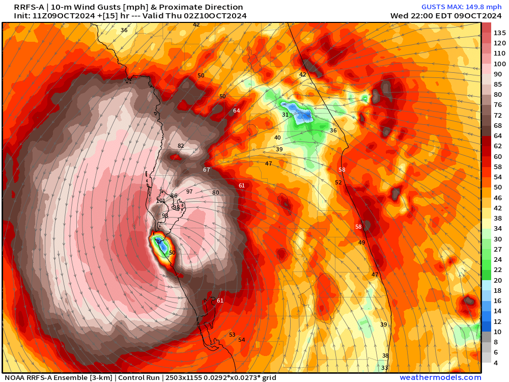
NWS maximum wind gust swath during Milton’s passage across Florida showing the footprint of 100-mph+ gusts extending just south of Interstate 4 to Orlando.

Maximum wind gusts of 100-130 mph include over the waters of Tampa Bay and surrounding cities to the south including Bradenton and Sarasota.

This will be a hurricane for the Atlantic coast of Florida as well as the storm circulation emerges over water and friction from land is gone — wind speeds will accelerate out of the SSE. Forecast max gust in Melbourne > 81 mph w/90 mph possible near the coast.

Model Depiction of Wind Gusts to Show Potential
RRFS-A 11z | Faster Landfall Solution
Wind gusts in mph


HRRR 11z Wind Gusts | Slower Track Solution

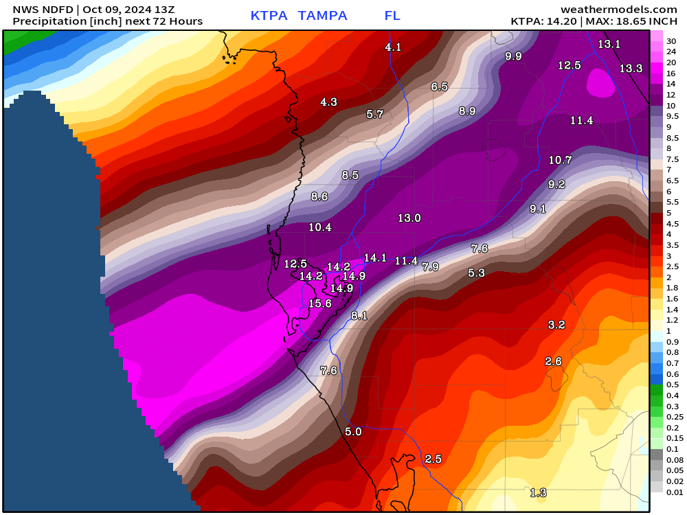
Rainfall Impacts Maps

NOAA WPC shows a large swath of rain of > 12-inches from TPA to Melbourne across the state from SW to NE
More detailed NWS has 14-18 inches surrounding Tampa Bay with the heaviest rain north of the center.
Coming soon: Weather in My Backyard
Maps sourced from weathermodels.com designed and innovated by yours truly! I actually create all of my content from scratch.
I really appreciate you keeping up with Milton and giving us real weather info.
This subscription is well worth it!
Great Analysis and Explainers.