


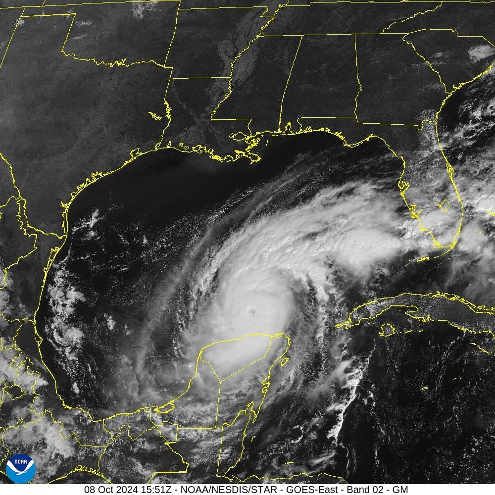
Oct 8, 2024 Hurricane Milton Eyes Florida
Eyewall replacement has changed Milton's structure making it a larger system

Weather Trader is a reader supported daily newsletter to keep you updated on extreme weather around the U.S. and Earth. Yearly subs or upgrades can use this coupon for 20% off [through October 11].
Headlines for Tuesday
Hurricane Milton [14L] reached 897 mb late Monday evening, the lowest central pressure since Rita/Wilma in 2005 in the Atlantic. [Sub-900 mb pressures are relatively frequent in the Western Pacific.]
11 AM ET: Central Pressure is 929 mb w/maximum sustained winds of 130-knots [150 mph] (Category 5) with ENE movement at 9 mph [turned slightly left]
Milton will slowly weaken in terms of maximum winds but expand greatly in size — wind footprint, rainfall shield, and cloud-cover.
Landfall intensity in terms of wind in the middle Category 3 range ~100 knots (115-mph) with a timing in the late Wed/early Thurs darkness. GFS is faster than ECMWF model with NHC favoring a faster solution.
Milton will evolve into a very large hurricane once it passes east of the Yucatan peninsula with extreme storm surge bombarding the Gulf Coast of Florida peninsula centered upon Tampa Bay + hurricane force wind gusts extending across the entire Florida peninsula along Interstate 4 corridor.
A marker to watch is the 25°N 85°W lat/lon intersection for angle of attack on the FL coastline.
897 mb Hurricane Milton

The central pressure bottomed out at 897 mb as measured by aircraft recon. However, if the planes were not in the air, then it’s possible the actual lowest pressure reading would not have been recorded or underestimated (too high pressure) for the history books. Obviously, our ability to observe these hurricanes today and more so than prior to WW2 helps maintain a good enough climate record.
Rita (895 mb) and Wilma (882 mb) from 2005, Gilbert from 1988 (888 mb) and the Labor Day Hurricane of 1935 (892 mb) all reached lower pressure than Milton.
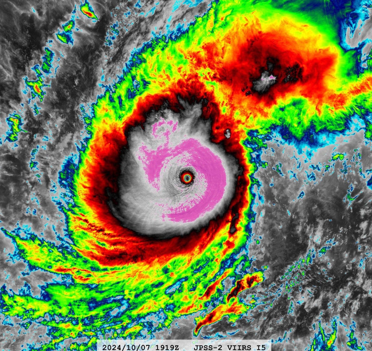
Hurricane Gilbert (1988) was incredible with a complete coverage of -80°C cloud tops surrounding a very warm, clear but tiny pinhole eye.

Comparison with the much larger eye of Hurricane Katrina (2005)

This structure is probably where Milton is headed later on Tuesday with a significantly larger diameter eye.
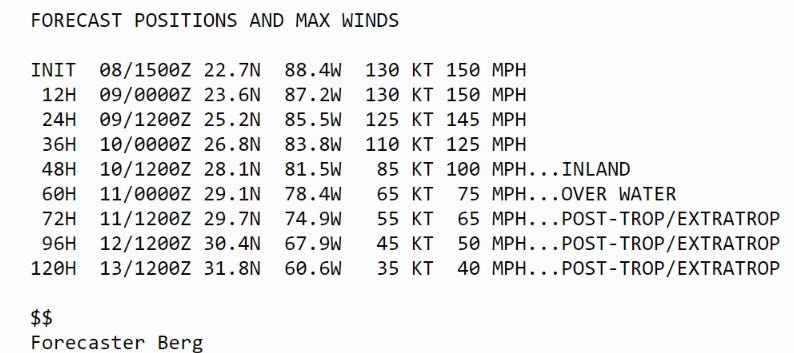
11 AM Track of Milton
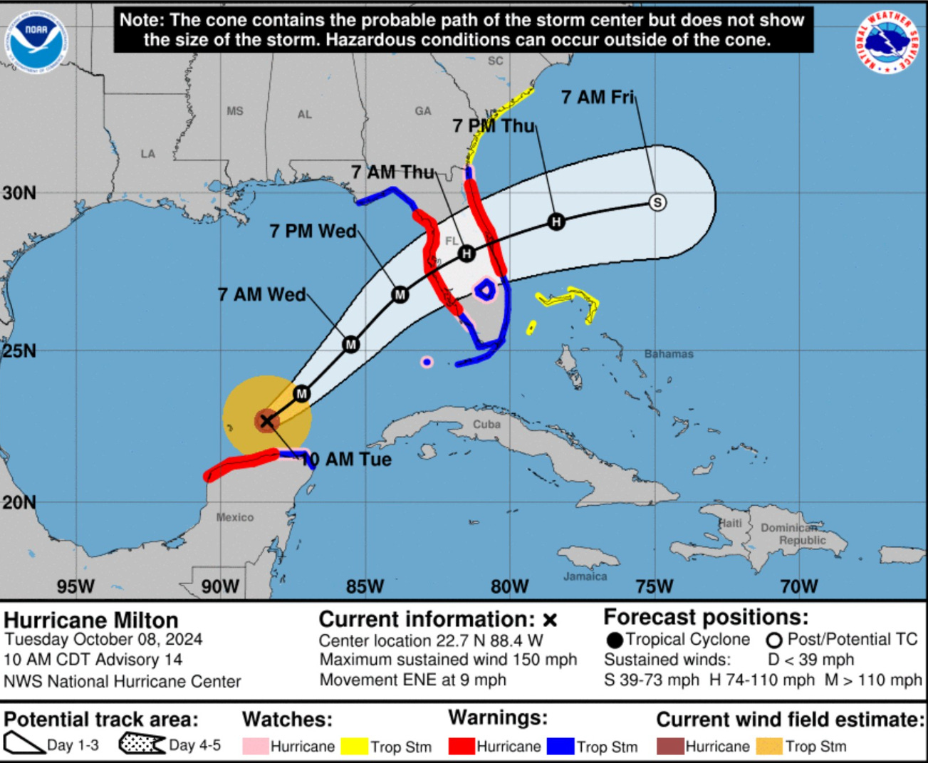
11 AM Track is parabolic so the connect-the-dot position maps are misleading. I haven’t quite figured out if there are official interpolated positions, or not.
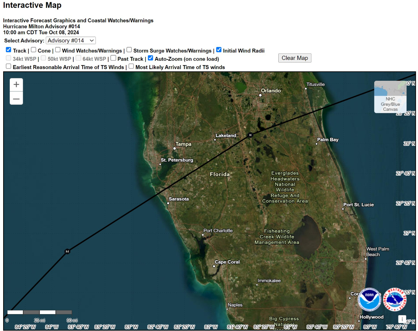
So, if you look at this interactive map, it seems like Milton travels south of Tampa Bay, when it actually would curve right through it assuming a curved path.
Official landfall would be late Wed night / early Thursday morning.
Landfall is when the center of the lowest pressure point (eye) crosses the coastline, so asymmetric structure of Milton might mean worst impacts come ashore well before the actual MSLP center catches up.
Milton moves through Florida relatively rapidly and is south of Orlando by 7 AM Thursday and gone by just after noon.
ECMWF 06z Hourly Track

This is more like what the track will look like on an hourly basis — more helpful to show the slight rightward bend at landfall from NE to ENE and then more E track once Milton clears the FL peninsula.
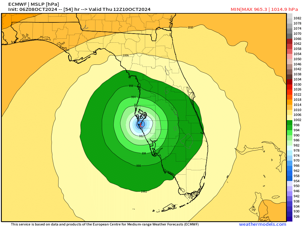
ECMWF 06z MSLP Center
ECMWF is slower than GFS by 7-8 hours, and the NHC is closer to the GFS forecast showing the storm over central Florida by 7 AM Thursday morning. This is an example of along-track uncertainty rather than cross-track.
09z October 10 —> Thursday at 5 AM

12z October 10 —> Thursday at 8 AM
GFS 06z MSLP Center
03z October 10 —> 11 PM ET Wednesday

05z October 10 —> 1 AM ET Thursday

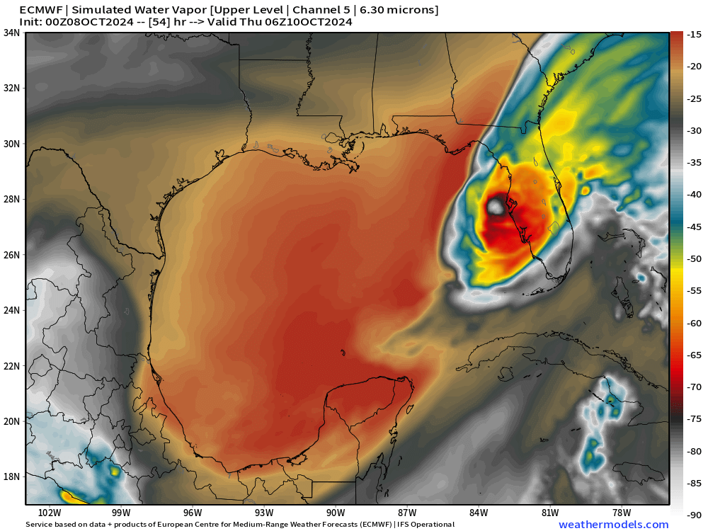
Simulated Water Vapor early Thursday
Taking into account the slower motion of ECMWF 00z/06z I’d focus here more on the structural change as the inner-core still will be under the obliterating effects of dry air + strong wind shear from a digging trough in the Gulf of Mexico.
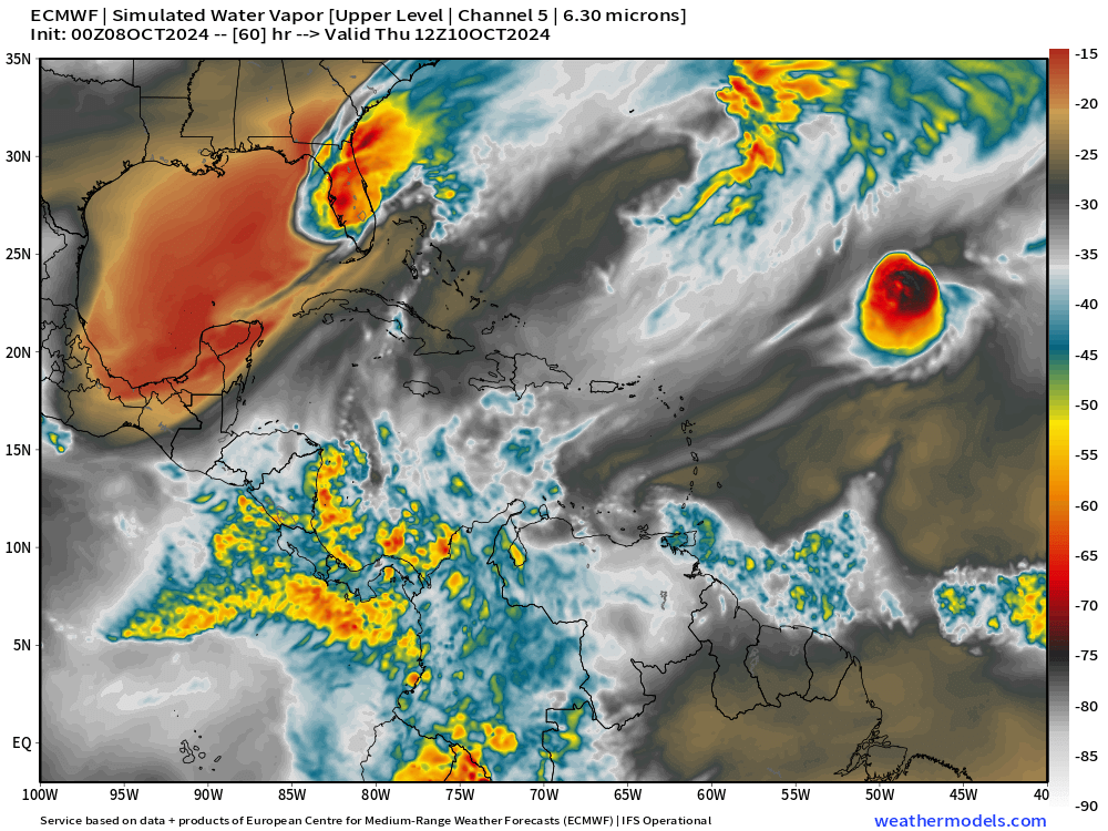
A little larger view — the overall storm structure will rapidly shift to more of a non-tropical system on Thursday.
Intensity and Impacts of Milton
NHC discussion highlights the uncertainty with the approaching trough and increase in vertical wind shear. However, it may not be enough to completely dismantle Milton prior to landfall but instead restructure the storm with a larger hurricane wind speed radius. Extratropical transition is sensitive to the phasing with the subtropical jet stream here in Milton’s case.
Milton is expected to maintain major hurricane strength while it moves across the Gulf of Mexico and approaches the west coast of Florida.

Stronger vertical shear is expected to set in about 24 hours, but even if this causes some weakening, it will not be enough to keep Milton from being an extremely dangerous hurricane when it reaches shore.

Additionally, the first stages of extratropical transition may be just underway as Milton is reaching the coast, which could impart some baroclinic energy and slow the rate of weakening.

The NHC intensity forecast is close to the top end of the model envelope, which includes the GFS and ECMWF models, since these models should have a better handle on a potential positive trough interaction.
The actual landfall intensity is less important than the wind speed and total kinetic energy + wind flux acting on the ocean surface to push the storm surge into the coastline.
Think of how Katrina was a Category 5 [902 mb] in the central Gulf of Mexico, winds and pressure weakened significantly to a Category 3 before reaching Louisiana coast. However, the eyewall replacement cycles actually increased the storm surge and piled the water higher over a larger area, which was then pushed ashore.
Landfall intensity: Category 3 105-knots and pressure in the mid-950s
Storm Surge Impacts
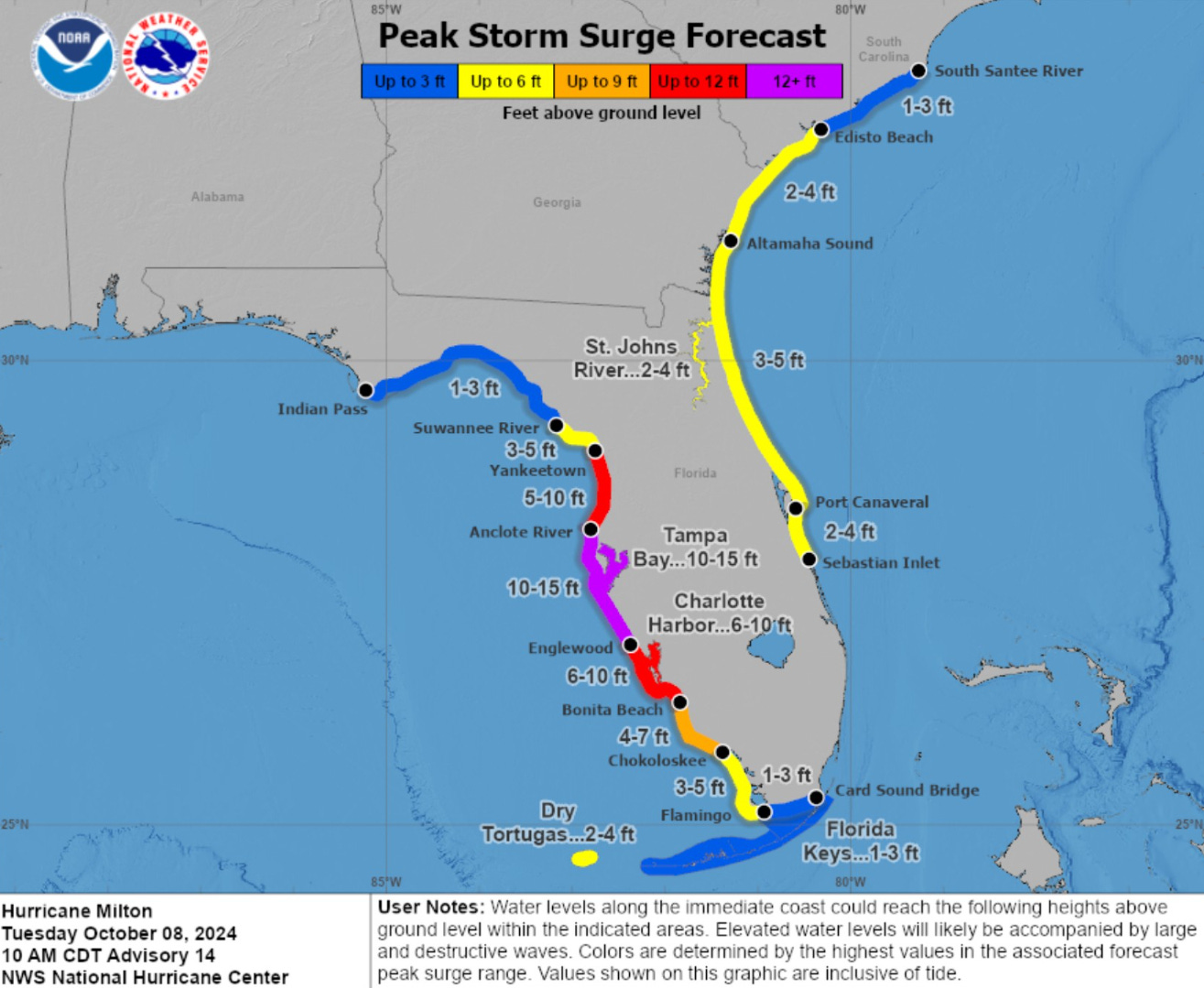
Maximum storm surge up to 15-feet including Tampa Bay.
Wind Gusts Impacts
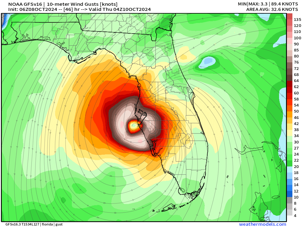
NWS wind gust swath — maximum throughout the duration of Milton’s crossing of Florida peninsula
This is the data that goes into the weather dot gov from NWS. The maximum wind gusts are in the 90-100 mph range in Tampa Bay.

Max wind gust at TPA is 80 mph forecast by NWS because the highest values are over the open water of Tampa Bay.

Orlando seems to be in the 93 mph max wind gust range assuming the inner-core of Milton holds together. I think this is overdone, but we can adjust the details on inland wind gusts later when mesoscale model data is more available like HRRR and RRFS.

ECMWF wind gusts are substantial off the Tampa Bay coastline up to 115-120 knots with clearly hurricane force along the entire coastline and inland 20-30 miles.

Wind gusts will come down in the 6-12 hours after landfall but still in the 40-60 knot range over much of Florida peninsula.

GFS inner-core looks more solid upon landfall.

I’d expect the threat for hurricane force wind gusts well inland including Orlando from a typical landfalling powerful hurricane. But this might not be the case with Milton. Again, those details can be narrowed down once the RRFS and HRRR get into range.
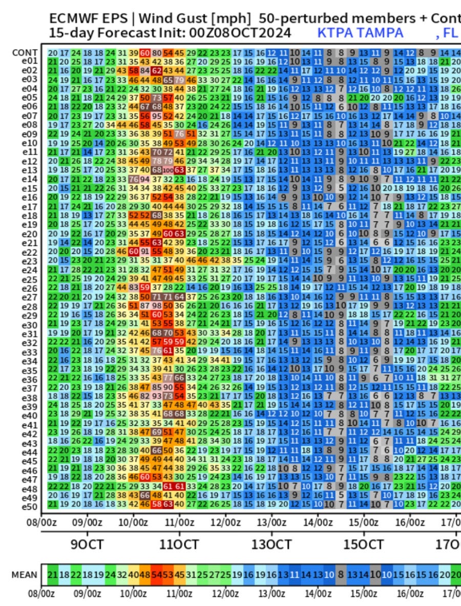
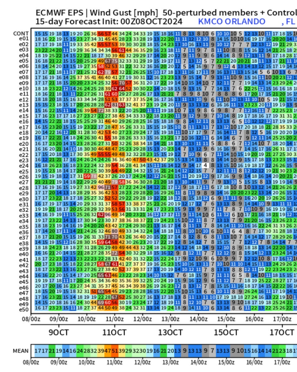
ECMWF Ensemble Wind Gusts for Tampa and Orlando
The ensemble mean is in the 50-55 mph range for maximum wind gusts experienced at TPA and MCO airports. There are many higher and lower numbers, of course determined by the exact track of the remaining eyewall. Outer bands could certainly have brief extreme wind gusts or embedded tornadoes that may not show up well on the ensemble matrix charts.
Rainfall Impacts
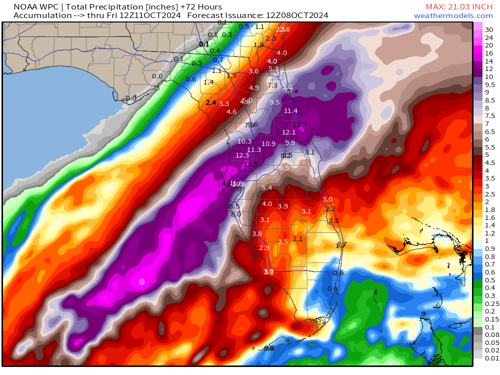
Total rainfall amounts from Milton have been significantly increased with a wide swath of 10-14 inches from Tampa to Daytona with the maximum gradient just along Interstate 4 suggesting a more ENE track across the peninsula. This rain will be falling at torrential rates as Milton plows across the peninsula.
Weather Trader is a reader supported daily newsletter to keep you updated on extreme weather around the U.S. and world. Please consider upgrading to a paid subscription to receive all updates to your email or click on the Substack App. Yearly subs or upgrades can use this coupon for 20% off:
Coming soon: Weather in My Backyard
Maps sourced from weathermodels.com designed and innovated by yours truly! I actually create all of my content from scratch.
What are the current ECMWF AIFS predictions I wonder?