

Oct 7, 2024 Category 5 Hurricane Milton
Gulf coast of Florida faces catastrophic storm surge from Milton by Wednesday

Weather Trader is a reader supported daily newsletter to keep you updated on extreme weather around the U.S. and world. Yearly subs or upgrades can use this coupon for 20% off [through October 11].
Headline for Monday
Hurricane Milton [14L] has explosively intensified in the past 18-24 hours, as expected.
2 pm: Central Pressure is 911 mb w/maximum sustained winds of 150-knots [175 mph] (Category 5) with East movement at 9 mph — important for maintaining the extreme intensity
Maximum wind forecast by NHC is probably 155-knots (T 7.5)
Milton will evolve into a very large hurricane once it passes east of the Yucatan peninsula with extreme storm surge bombarding the Gulf Coast of Florida peninsula centered upon Tampa Bay + hurricane force wind gusts extending across the entire Florida peninsula along Interstate 4 corridor.
Track of Milton
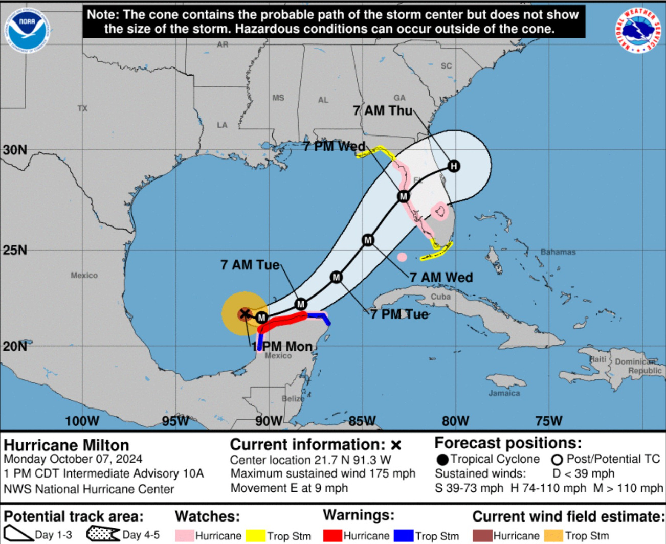
The 2 PM ET track has ticked northward into Tampa Bay with a landfall near or over St. Petersburg, then on a line to Orlando.
As noted yesterday, wind shear and dry air will be disrupting the circulation of Milton prior to reaching the coast, the overall system inner-core may be more like a “half-cane” and transitioning into an extratropical or post-tropical storm. That would mean impacts spread out of a larger area, especially inland.
The models also show a more abrupt right or eastward turn than the either the smoothed NHC forecast cone map or the connect-the-points version.
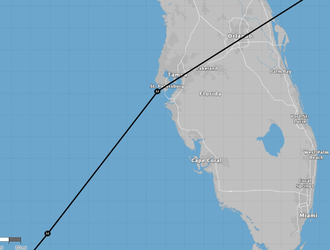
ECMWF 12z Track

Here’s the interesting right turn or eastward jaunt across the peninsula for Florida post-landfall in response to the capture by the upper-level trough.

NHC consensus models have been leaning in the direction of ECMWF within 10-20 miles of Tampa Bay. Up until GFS 12z, the model was up in Cedar Key with landfall, a northern outlier.
Simulated Water Vapor at 8 PM on Wednesday

From simulated water vapor imagery, a strong trough digs into the Gulf of Mexico and obliterates the inner-core of Milton coincidentally with landfall. 6-hours later:

Note, the MSLP center is in the process of coming ashore at 2 AM ET on Thursday.

Landfall inner-core still looks coherent at +60H but comes apart rapidly thereafter.
Structure changes will be rapid by Wednesday evening.
ECMWF 850 hPa Wind Speed | Inner-core obliteration
+60 Hours

+66 Hours

GFS 12z track — for reference also shows the rightward turn upon landfall, but further to the north. Currently NHC official forecast is still a bit south of GFS.

ECMWF AIFS 06z

And, the artificial intelligence (AI) trained version of the ECMWF called AIFS is further south than the HRES and NHC. Just watching this going forward but not putting undue weight upon the solution.
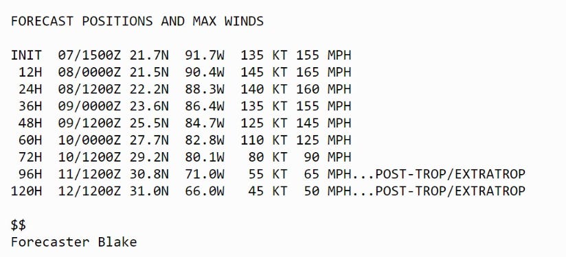
Intensity and Impacts of Milton
The 11 AM NHC discussion is already 15 knots too low, but helpful to show expected diminishment of peak winds prior to landfall in western Florida.
Keep reading with a 7-day free trial
Subscribe to Weather Trader to keep reading this post and get 7 days of free access to the full post archives.