


Oct 4, 2024 Friday Tropical Update
Gulf of Mexico could see powerful hurricane develop by early next week and impact Florida


Weather Trader is a reader supported daily newsletter to keep you updated on extreme weather around the U.S. and world. Please consider upgrading to a paid subscription to receive all updates to your email or click on the Substack App. Yearly subs or upgrades can use this coupon for 20% off [through October 11].
Headlines for Friday
Hurricane Kirk and Tropical Storm Leslie well out to sea. Kirk will affect UK/Europe in some capacity later next week. And, another wave following could become Nadine in ~1 week.
Gulf of Mexico TS/Hurricane [Milton] looks likely according to afternoon model guidance with formation in the Western Gulf with landfall by Wednesday into central Florida. There is a wide range of intensity outcomes including major hurricane. Normally I wouldn’t sound the alarm 5-days out, but the ensembles are highly certain about a named tropical system developing. NHC is at 50% chance of development.
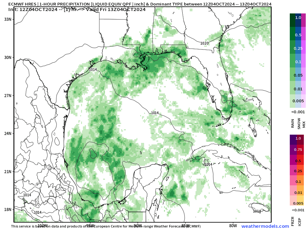
Gulf of Mexico Disturbance
An area of low-level vorticity with contribution from the Eastern Pacific is strung out along the Mexico coastline in the Bay of Campeche. A broad mid-level circulation is apparent with a gyre that has remained stuck over Central America for the past 2-3 weeks.
Development of a low-pressure center will be slow and take 3-4 days. ECMWF 12z did develop a TD/TS by Sunday with only slow intensification. However, the Gulf waters are very warm and capable of any intensity hurricane in early October. This is a rare track for this time of year, too.
By early Tuesday +90 Hours (ECMWF 12z) we see the model simulate a very large convective canopy over the low-level center. This looks quite ominous without any wind shear at this time. The environmental conditions aloft will become less favorable as to-be Milton reaches the Florida west coast. However, as we’ve seen with Francine and Helene, the upper-levels seem to rearrange into a favorable configuration that enhances the hurricane rather than knock it down.

By Wednesday morning (8 AM) there is a 979 mb hurricane on Florida’s doorstep in the ECMWF 12z model. This is strong Cat 1 or weak Cat 2. It’s too soon to detail the landfall location or the intensity.
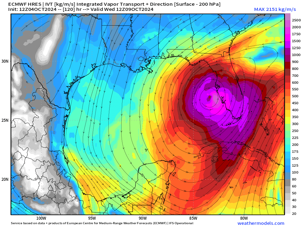

ECMWF 12z Integrated Vapor Transport (IVT)

The evolution of the Gulf of Mexico systems shows up well on IVT as the circulation takes over the western half of the basin.
Leslie seems to fall apart in 6-7 days as it reaches about 25°N latitude. Another wave off of Africa shows promise and would become Nadine.
Weather Trader is a reader supported daily newsletter to keep you updated on extreme weather around the U.S. and world. Please consider upgrading to a paid subscription to receive all updates to your email or click on the Substack App. Yearly subs or upgrades can use this coupon for 20% off:
Atlantic GeoColor Satellite
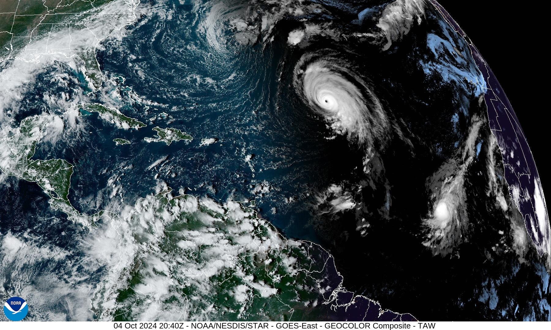
Beautiful simulated night time visible view of Category 4 hurricane Kirk and smaller TS Leslie.
Gulf of Mexico IR Satellite
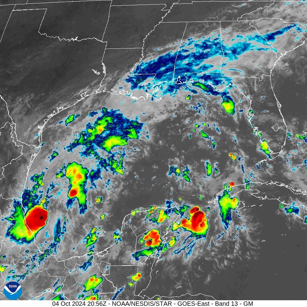
Only scattered convection across the Gulf of Mexico in the Bay of Campeche. Expecting this to linger and eventually consolidate.
NHC 7-Day Outlook
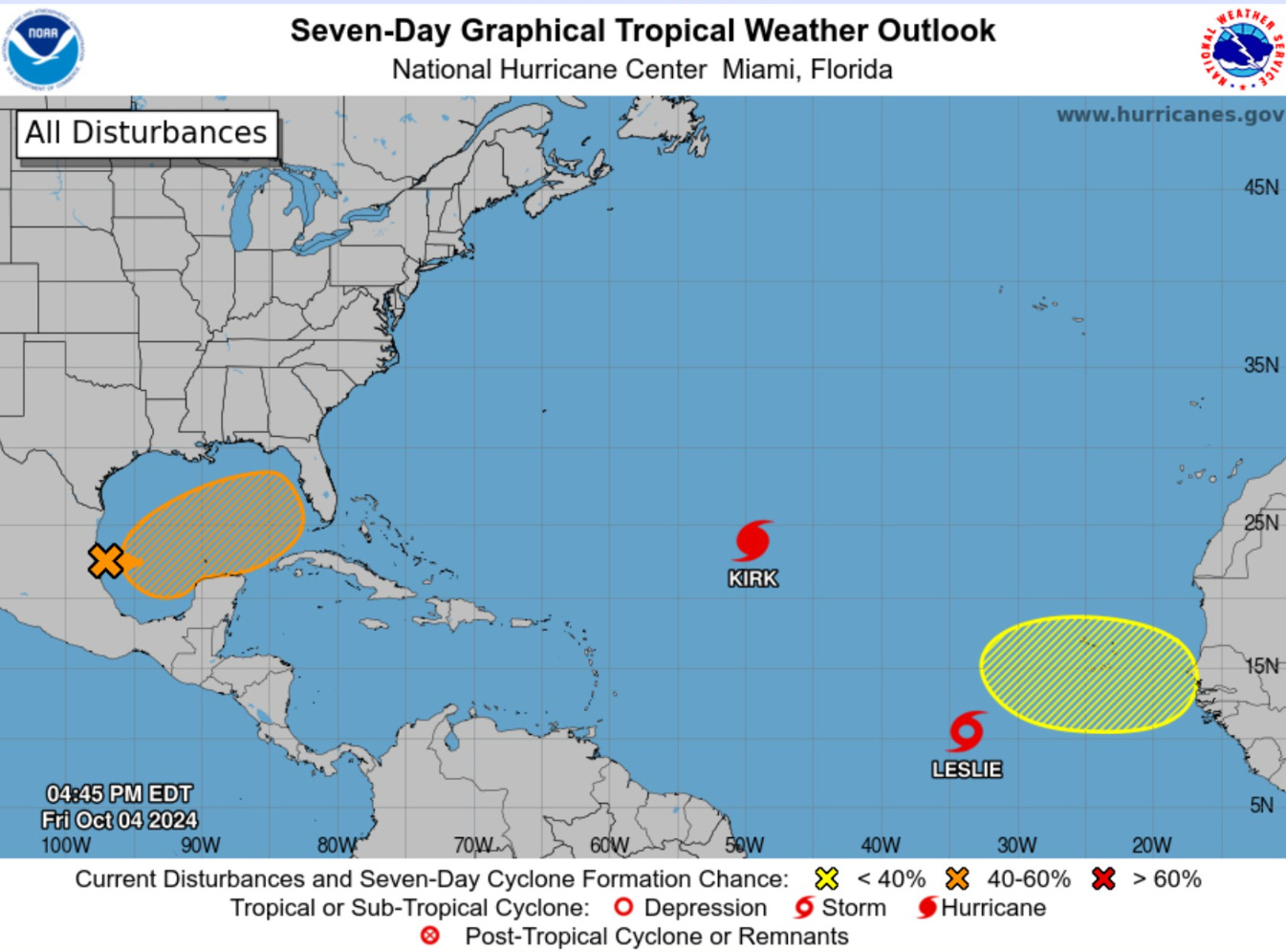
We’re up to 50% within the Gulf of Mexico through 7-days. Kirk and Leslie are on their merry way in the open central Atlantic. One more area off Africa down the road (10%).
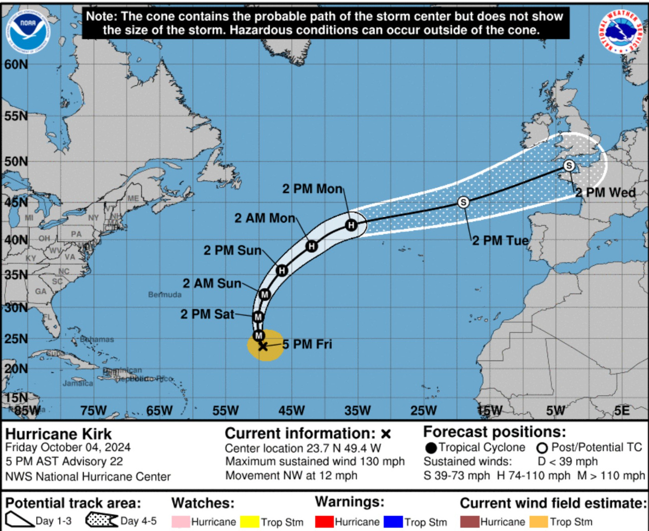
Hurricane Kirk
Kirk peaked at Category 4 but I think it blipped up to Cat 5 but just prior to the NHC advisory so perhaps the end-of-season analysis will upgrade it.
However, I think these situations could also be like NFL replay reviews: the call on the field stands.
Tropical Storm Leslie
ECMWF 12z Tropical Cyclone Tracks
Day 2.5: October 7 00z

The ensembles start cooking by late Sunday evening.
Day 5: October 9 12z

All aboard the train by Wednesday morning. Some along-track uncertainty with the landfall timing. There are many members at very high intensity —> H3.
Spaghettios at Day 5

Day 7: October 11 12z

Day 15: October 19 12z | All Tracks

NWS WPC | 7 Days Total Precipitation

Major rainfall threat with the tropical system over Florida.
Coming soon: Weather in My Backyard
Maps sourced from weathermodels.com designed and innovated by yours truly! I actually create all of my content from scratch.
That would be catastrophic if Milton develops and reaches hurricane status impacting west Florida again.