


November 27, 2024 Wednesday Winter Weather Update
Much below normal temperatures could linger for 10-14 days across the Northeast

Wednesday Headlines
Storm system tracks out of the Ohio Valley into New England with rain and rather heavy snow on the backside — well inland away from the coast.
Cold air behind an Arctic front with strong high pressure settles into the Southeast by Monday morning
Longevity of cold might be worst in the Northeast as uncertainty about ability of western ridging to push polar vortex far enough north into Hudson Bay / Canada to prevent troughs from digging much into the eastern U.S. by Day 10. Uncertainty about a secondary Arctic blast into 2nd week of December.
I will have an op-ed in a newspaper published online Sunday [6 AM] with thoughts about U.S. weather forecasting in a second Trump administration.
Current 10% coupon for Annual Subscription [through November 30]. $5/month or $50/year through December 31.
Next 7-Days Temperature Anomaly [°F]
Not much doubt about the origin of the much colder air: straight out of Alaska and the Canadian Arctic. However, that express lane might get pinched off by strong North Pacific ridging. Instead, the source for colder air across the eastern US by Day 10 would be from the north over Hudson Bay.

Coldest Mornings: Monday and Tuesday
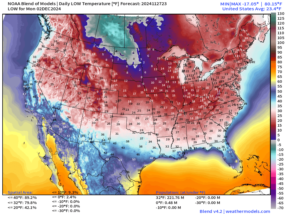
221 million Americans will be at/below freezing with 20s into central Georgia and near-freezing in North Florida. By Tuesday, a bit colder with near freezing temperatures to the Gulf Coast and down I-75 into Ocala area. NWS has 35°F for Ocala on Tuesday morning with Blend of Models at 34°F. Not expecting any record lows — it’s hard to set any in early December.

Upper-Level Pattern | ECMWF 12z | Next 10-days

The animation is from ECMWF HRES 12z and shows through time the evolution of the upper-level height field anomalies. You can pick up on the origin of small deviations in the Arctic swinging south/southeast like a pendulum where they dig into intense troughs. Good example is the small but potent cold pool over Quebec and Canadian Maritimes by Day 10. That feature is to be watched vs. the quite strong ridge over the Western U.S. Note, the little cut-off stuck under that ridge over Baja California.
Day 10: A.I. trained models | ECMWF initialization


The A.I. based models all agree on the general upper-level pattern over North America at Day 10, but uncertainty about the intensity of the western ridge and the extent to which the trough digs into the Northeast.
Day 10 | Physics based Models | ECMWF and GFS deterministic + ensemble


Now, looking at the physics based models: ensemble mean on the top row, and the deterministic versions on the bottom — ECMWF and GFS.
The ensemble means look much more like the A.I. trained systems since the error minimization strategy with the A.I. training tends to hedge and smooth at longer forecasts like after 7-8 days.
However, the deterministic forecasts keep their detail and sharpness. I find them more useful. You can tell that the GFS and ECMWF HRES could easily be examples out of the basket of ensembles.
HRRR | Radar Simulation through Friday afternoon
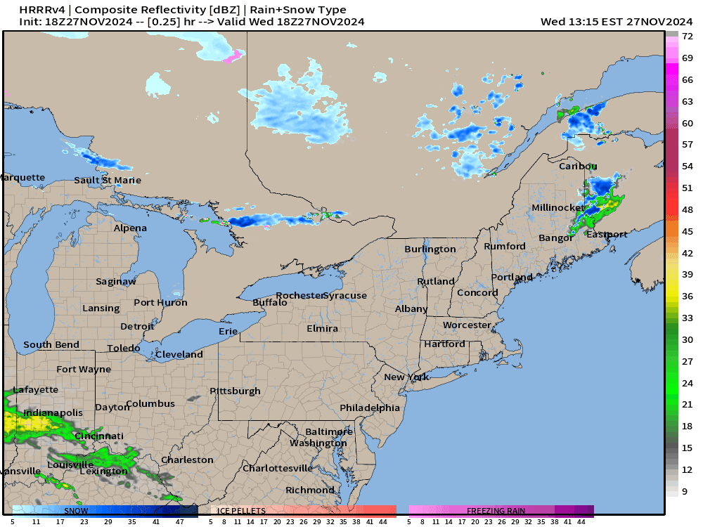
Thanksgiving snow storm followed by Black Friday Lake Effect snow machine.
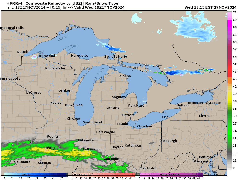
NWS Snowfall Next 3-days has increased in terms of storm system snow with 6-8” painted across New England. Already 40” expected through Saturday evening off Lake Ontario. 20”

Based upon the wind direction … only 2” through Saturday evening at KBUF (Buffalo) with implications for the 49ers and Bills on Sunday Night Football (8 PM)

I think the amounts along Lake Michigan are underdone. Will also be windy!

To continue supporting Weather Trader into the Winter 2024-25, please consider subscribing or upgrading to an annual commitment with 10% off incentive through November 30.
Keep reading with a 7-day free trial
Subscribe to Weather Trader to keep reading this post and get 7 days of free access to the full post archives.