


May 30, 2025 Friday Tropical Update
Next chance of a system in Eastern Pacific later next week. Atlantic quiet through first week of June

Friday’s Tropical Weather Headlines
Atlantic tropical update: not expecting any development through at least 7-days, but LOW chance for a tropical storm in the Caribbean or Gulf of Mexico after Day 10 [into second week of June]. Ensembles in the long-range
show a Caribbean / Central American gyre circulation in early June that is conducive to spinning up tropical storms in the Eastern Pacific & Caribbean/Gulf.
Eastern Pacific tropical update: ALVIN (01E) won’t be with us much longer as wind shear and dry air will suppress deep convection and leave a low-level swirl. Leftover moisture will be pulled into the U.S. Southwest ahead of an upper-level trough.
Saharan Dust / Air Layer [MAJOR] blasting off African coast to squelch any tropical waves for a 5-7 day period across the MDR. The dust will impact Gulf coast states and be noticeable as a haze in the afternoon sky.
Lack of a hurricane through June 4th — means 2025 will be the latest (since 1973) to NOT see a hurricane strength tropical cyclone in the Northern Hemisphere for the current calendar year. No dice in the Western Pacific for the next 7-10 days, or who knows when. 1973 was a strong (!) La Nina. Our next legitimate shot at a “Hurricane” strength system is in the Eastern Pacific with Barbara by June 7-8.
Integrated Vapor Transport | Next 10-days
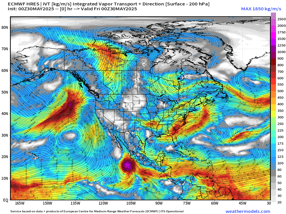
The ECMWF HRES (control) IVT model simulation for the next 10-days does not show anything spinning w/tropical designation across the Atlantic.
Deep layer moisture does traverse the Caribbean at Day 7, but the intensity backs off as “Barbara” cranks up off the coast of Mexico.
A very strong high pressure cell is locked in across the Pacific NE of Hawaii into the Gulf of Alaska. Rossby wave thinning on the downstream side off the coast of California is spinning cut-off lows / troughs as higher (planetary) relative vorticity air is pushed south.
Precipitation and MSLP Next 10-days

Only show in town in the tropics will be potential EPAC system number 2.
Precipitable Water Next 7-days
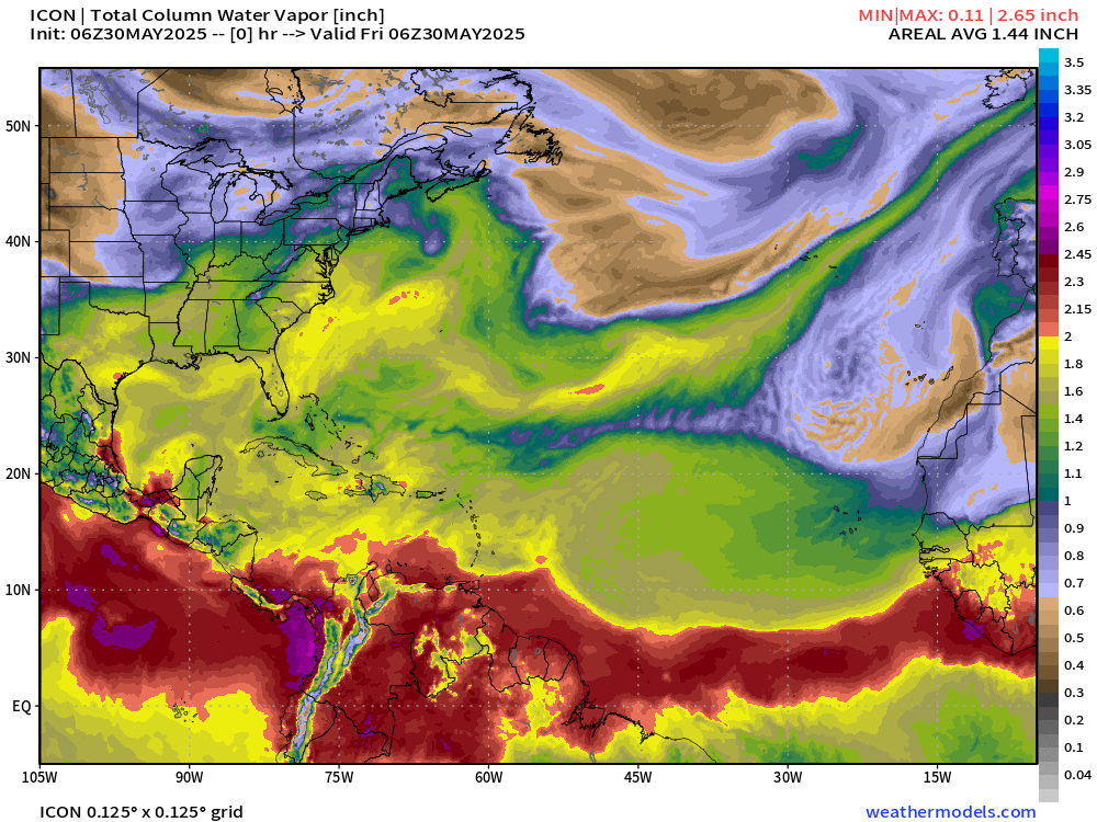
My favorite parameter PWAT — next 7-days. You can see the surges of Saharan Air Layers (SAL) from the African continent as wave fronts blasting westward with lower PWAT (yellow) pushing the red (2-inches+) out of the way. A very sharp gradient exists along the periphery of the SAL to the ITCZ/monsoon trough.
High PWAT continues to collect over Central America waiting for some low-level vorticity to come along and take advantage, but only on the Pacific side are upper-level winds favorable.
Subscribe for 2025 Hurricane Season Updates — Know what’s coming down the pike 2-weeks ahead of time.
Atlantic Basin
Eastern Atlantic Satellite Image
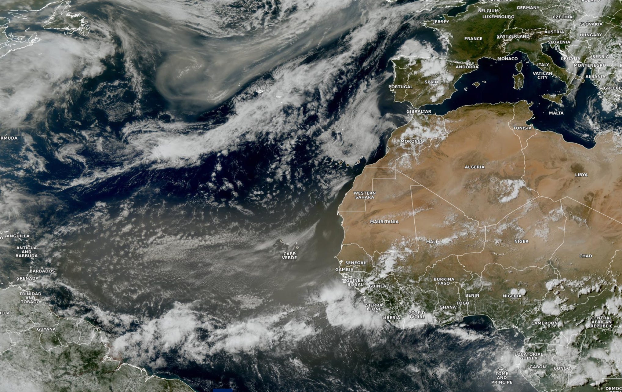
Major dust cloud now reaching the Lesser Antilles and circulating anti-cyclonically into the Gulf of Mexico into middle of next week.
A break in the SAL for 5-days before another plume emerges off African coast. There’s no chance of development of a tropical storm in the Eastern Atlantic regardless of this dust as the ocean temperatures are too chilly — until probably mid-July.
NASA-GEOS5 Dust | 7-days Forecast
Keep reading with a 7-day free trial
Subscribe to Weather Trader to keep reading this post and get 7 days of free access to the full post archives.