


May 1, 2025 Thursday Weather Update
Comfortable and cool first half of May ahead
Good Morning!
Looking back at the last month of April 2025 temperature anomaly: the Lower 48 was on average 1.5°F above the 1991-2020 climatology. Generally 3°F to 5°F above normal from Texas into the Carolinas. Near normal or slightly below with some hints of blue mixed into the Midwest. Late month snowfall in Wyoming tipped the month to the colder side.

Next 30-days CFSv2 Temperature Anomaly
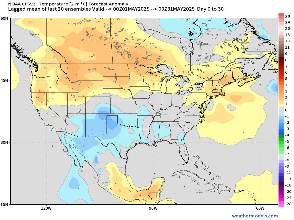
May does not look hot across the Southern U.S. from Texas to the Southeast with near-normal temperatures or even below normal. This takes into account the last 5-days of forecasts from CFSv2 (a climate model that is a distant cousin of GFS).
Temperature Analysis | 10:00 AM ET

Nicely into the 70s into Ohio and Washington D.C.
Temperature Anomaly | 10:00 AM ET

Overall the Lower 48 is 2.6°F above normal
Today’s High Temperatures | Thursday

251 million at/above 70°F = 55% of the real estate but larger % of population since much of the Western U.S. is not densely populated (mountains!)
Highs in the mid-80s in Washington D.C. and pushing 90°F in central Virginia.

Satellite Imagery this Morning
Convection over the Great Lakes stretching in a broken line of lighter showers into Louisiana

Quite a bit of cloud cover keeping temperatures down over 1/3 of the Lower 48. Maine is clear and south Georgia into Florida look wonderful. South Carolina almost entirely clear. The Mid-Atlantic is also quite nice this morning.

Radar: 10:10 AM ET

Low pressure in Illinois tracking northward into the Great Lakes with a solid slug of rainfall and embedded storms from Madison, Wisconsin across to Alpena, Michigan. Everyone getting a good drink of free water this morning.
Weather Today | Thursday

Warm, moist pattern eventually gives way to frontal boundary out of the Plains to clear out the rain and scattered storms. However, until that can be pushed off the East Coast, we continue to see rounds of thunderstorm development again from Oklahoma and North Texas into the Southeast heading into the Ohio River Valley. Only a Slight Risk of Severe Weather.
Quick update on a New Paper from NOAA GFDL and Japan colleagues working to explain the overprediction of the North Atlantic hurricane season at least through September. Of course 2024 was a busy year with damaging storms (Helene) but they are not discounting the seriousness, but trying to understand why the hyperactive seasonal forecasts did not verify until a busy October picked up the pace.


The suppressed development of La Nina did NOT have a major impact but instead Saharan Dust Layers likely squelched African Easterly Wave action, which we noticed and highlighted all last year on this blog — and quoted in the press.

I don’t think this was difficult to understand while the season unfolded especially if you watched the coast of Africa from July to September.

NASA GEOS-5 Dust Analysis Today

Dust is already extending across the Main Development Region with another strong plume coming off the African continent. These dust clouds limit storm development and generally reduce solar insolation and are a net cooling agent for the ocean surface.
Drought Monitor Update
Focusing on Florida today to show the worsening drought situation — and discuss later any hopes for rain in the Sunshine State.

Extreme Drought (D3) has shown up from Daytona Beach to Ocala, and across South Florida.

The drought monitor matches up well the last 180-days of rainfall across Florida, which is only 7” to 8” in the D3 regions. Much more has fallen in the panhandle since November 1st. Very dry last 6-months from Gainesville to Miami!

This is a deficit of a LOT of rainfall that’s missing compared to normal: upwards of 7” or even 12” around Palm Beach. A red map is not good!

During the last 3-weeks, some coastal showers and storms developed but not much coverage inland at all. We still wait for sea breeze season!

Ridge over Trough Blocking Pattern into this Weekend

A weird pattern develops with a ridge over two cut-off troughs blocking the Lower 48 — a major change/flip from the highly progressive or busy pattern of the last 2-3 weeks.
This means air flow out Canada is trapped in the Southwest and the Southeast U.S.


Sunday evening Temperature Anomaly from AIFS shows the cool air over the U.S. Southwest and another blob centered on Ohio River.
Today’s Weather
HRRR next 18-hours through 2 AM ET on Friday

Scattered showers and storms across south Texas could be severe supercells and a few more scattered into Louisiana might be strong.
The rain and storms with the low pressure system rotate counter-clockwise through the Great Lakes.
Max Radar next 18-Hours to summarize today’s shower and storm coverage:

Slight Risk of Severe Storms

All new paid subscribers can use this coupon link to receive 20% off the Newsletter and receive all daily updates heading into hurricane season.
Keep reading with a 7-day free trial
Subscribe to Weather Trader to keep reading this post and get 7 days of free access to the full post archives.