


March 3, 2024 Very Warm and Wet Week Ahead But Chance of a Weekend Nor'easter
Very wet across the East and chance of a Weekend Winter Nor'easter
Weather Trader Update | Sunday Evening
While the Western U.S. is under the influence of a strong Arctic trough, snowfall will continue to pile up in the mountains. More than 100-inches registers on a numerical snowfall analysis but undoubtedly blowing and drifting has made literal mountains out of snowbanks. The videos of Interstate 80 were bone chilling. I would not want to be stranded or as NWS Reno said “impromptu camping”.

Meanwhile, east of the Rockies, it is Spring Fever again with temperatures in the 70s well into the Great Lakes including Chicago, Detroit, and maybe Buffalo.
Monday High Temperatures | March 4, 2024

These high temperatures on Monday are 30-35°F above normal in the Great Lakes for March 4th. Florida is in the 80s as well as Dallas.
Next 8-Days Weather | ECMWF 12z HRES
The main story will be flooding / excessive rain first for the Gulf Coast and Southeast and then up into the mid-Atlantic and Northeast.
7-Day NWS WPC Rainfall

Huge rainfall amounts by mid-week begin to fall across the southern states then up the eastern U.S.
The red is widespread 2-4” or more including D.C., NYC, and Boston, up to 6” locally in Atlanta. Not a fan of this at all.

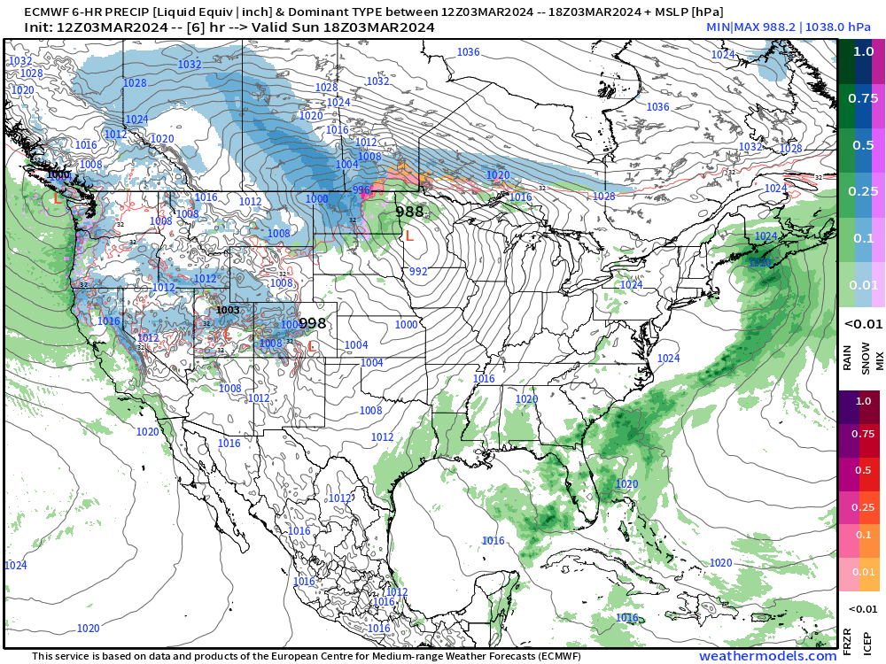
Winter Weather Chances in the Northeast
There is an outside chance that the first coastal low could have enough cold air to provide snowfall for New England, perhaps Boston on the very edge and Maine.
However, much better chance of a legit Nor’easter next weekend.
This is a decent snow storm signal for Boston from the 12Z Ensembles — about a 40-50% chance of accumulating snows.

The 10-day median snowfall amounts are much less robust for the immediate coastline but 7-10” into northern New England.
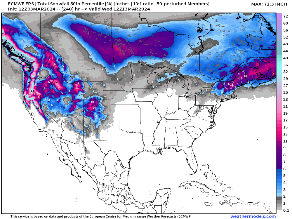
The probability of 3”+ snowfall is 40% range for Boston but 60-90% over Maine.

AIFS ECMWF | Artificial Intelligence Inference
Early Friday

Amazing, almost out of the blue, ECMWF provided their AIFS data to the community for free in real-time. So, now we have another — and probably by far the best — A.I. trained weather model available along side the other guidance from GFS, ECMWF and other outfits. Unfortunately, we don’t have all of the parameters necessary to show snowfall, but we can deduce it based upon the 2-meter temperatures and precipitation.
AIFS-ECMWF does have a weak area of low-pressure off New England late Thursday, so this is certainly worth watching to see if enough cold air is available. I’d still put the odds at 10% for coastal snow, and 25% for significant inland New England snow on Friday.
Early Sunday AIFS
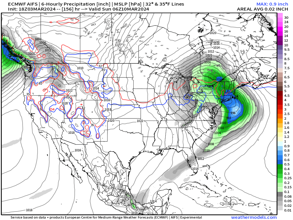
However, by the weekend, as we saw in the conventional ECMWF HRES IFS modeling, there is a powerful Nor’easter right over New England in the sweet spot for heavy snowfall.
We will watch AIFS and IFS, as well as the ensembles over the next 1-2 days to nail down the details.
You can view the AIFS-ECMWF as well as the other 4 A.I. models here at Climate Atlas:
Overall Warmth Continues into Mid-March
ECMWF AIFS
Week 1 | Next 7-Days | March 3 - March 10, 2024

Week 2 | March 10 - March 17, 2024

Climatology increases each week heading into Spring, so these above average temperatures mean that much more!
Thank you to Subscribers and Supporters! Welcome to March 2024 — so much is going on in the world of weather! Please come along for the ride!
Thanks once more for the excellent data 👍
Very happy to see Weather Trader giving us the AIFS-ECMWF predictions 👍👍