


March 25, 2024 Central U.S. Storm System Continues with Snowfall and Severe Thunderstorms
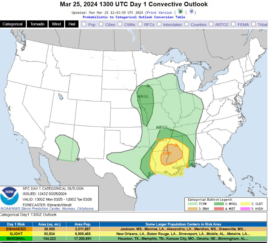
Enhanced risk of severe thunderstorms in Louisiana on Monday

The central pressure of the storm system was analyzed at 12 UTC at 989 mb and dropped as low as 981-982 mb earlier while centered over Colorado/Kansas.
Very cold air for late March is behind the cold front sinking into North Texas. Ahead of the cold front in the warm sector is Enhanced Risk for severe thunderstorms later in the evening including near New Orleans into Mississippi.
Minneapolis will see rising temperatures today as a warm front pushes north = rainfall rather than ongoing snowfall. What an ugly day.
The Ohio Valley will see warmth in the 70s with southerly winds in the warm sector. Cincy will be sunny and 70°F this afternoon for the best weather east of the Rockies.

8:45 PM ET Temperature analysis

The Upper Midwest and Central Plains west of the cold front only in the teens — some single digits in the Dakotas. Cold!
Pushing 60°F this morning in St. Louis. Chilly in New England in the 20s.
42% of the Lower 48 real-estate is at/below freezing, but only a fraction of the population ~8% (28M)
Next 18-hours Weather | Simulated Radar | HRRR | Through Rest of Monday

Snowfall continues behind the low as cold air settles into the Central Plains
The squall line through Louisiana and Mississippi will be the focus of Enhanced Risk of Severe Weather.
Next 48-hours Temperature | HRRR | Through End of Tuesday
This temperature animation shows the rather slow progress of the Cold Front over the next 2-days, but the cold air behind it will freeze OKC and St Louis. No Spring yet!

Next 8 Days Weather Pattern

Overall — more quiet week once this storm system exits into Canada, and the cold front clears the East Coast.
The West Coast will remain unsettled with waves of rainfall with coastal fronts = boatloads of moisture for continued snowfall in the mountains = MORE snowpack into April = GOOD!
Monday High Temperatures

Ahead of the front, temperatures warm in the 60s and 70s — including Cincy and Lexington, KY. 80s in Florida, of course.
3-Day Snowfall | NWS NDFD

Another drenching for the entire Southeast from this frontal boundary — up to 3” in Tallahassee. South Florida remains dry through 72-hours = make for happier Spring Breakers.
WPC 7-Day Precipitation Forecast

Temperature Outlook Next 14-Days

Western U.S. generally colder than normal.

Week 2 = close to average across the Lower 48 with the only significant anomaly (cool) over the Southwest.
Alas, no Early April heat wave — but seasonable temperatures.
Ensemble 50th Percentile Snowfall 15-Days


Once this current snow event leaves the scene on Tuesday, this 15-day ensemble median snowfall map + Control Ensemble will be retired for the “Winter” season —East of the Rockies. Unlikely to see another Winter Storm in the Northeast or Great Lakes.
Thank you to Subscribers and Supporters! Almost Spring 2024 and the growing season — so much is going on in the world of weather! Please come along for the ride!
Maps sourced from weathermodels.com designed and innovated by yours truly! I actually create all of my content from scratch.