

March 22, 2024 Overtime Winter Ahead
Seasonal forecast for Spring is favorable as El Nino signals linger

Good evening. Hopefully you were living somewhere able to enjoy the Spring warmth. Of course, there are plenty of folks that don’t mind the cold weather — and appreciate the seasons — especially in the Midwest. I felt that way when it was 92°F in Tallahassee from May until September with oppressive humidity. So, I escaped to Atlanta where we certainly have a decent 4 months of winter, but very little snow, thankfully.
Your humble correspondent was quoted in the AP today on the Spring forecast. And since I’m actually forecasting these days — allegedly — instead of only just making colorful maps, I am able to provide “expert” analysis. I am eternally grateful for anyone that takes the time to ask for my opinion, and I take every request very seriously since I want to provide value and honesty when it comes to weather forecasting.
This is what I wrote in a response email in addition to what Seth chose to quote:
Their [NOAA CPC] outlook is what one would expect for an oncoming La Niña heading into summer looking at analogs. However, we're not yet seeing the cooler waters emerge to the surface in the eastern Equatorial Pacific. Soon -- few weeks -- and then it will be quite apparent.
The good news is that residual El Niño signals remain, and over the next 2-weeks, we may be seeing winter go into overtime as cooler air and northwesterly flow with a dip in jet stream east of the Rockies.
This means considerable moisture streaming from the Pacific onto the west coast and into the Rockies. = more snow pack
Then, weather systems with the typically active Spring storm track pull moisture out of the Gulf of Mexico, and deposit it on the Southeast and up the east coast.
Since there's still cold air for snow, the Midwest and Great Lakes will see a late-March "overtime winter"
And, this is great for farmers who are observing drought risks in the Plains where winter snowfall and precipitation has been well below average.
The threat later in May/June is that a La Niña signal intensifies quickly leading to "heat domes" and long-lasting ridge of high pressure smack dab over the central U.S.
In summary, the next 4-6 weeks will hopefully be a gradual transition from a mild winter into a wet, unsettled spring with lingering El Niño weather patterns.
The groundhog was right about the early spring warmth during the first half of March, but now the worm has turned because of the lingering effects of El Niño. A mild, wet pattern for next 1-2 months will probably give way to a hot, dry La Niña summer, but until then, we may actually see a legitimate spring transition season rather than flipping the switch directly to summer.
7:30 PM ET Temperature Analysis

Thursday was a wonderfully mild day across the Southeast with temperatures up to 77°F in Atlanta. Still 60 million Americans at/above 70°F in the evening hours.
The Midwest, Great Lakes and Northeast are still stuck in winter!
Next 18-hours Weather | Simulated Radar | HRRR | Through Friday Morning
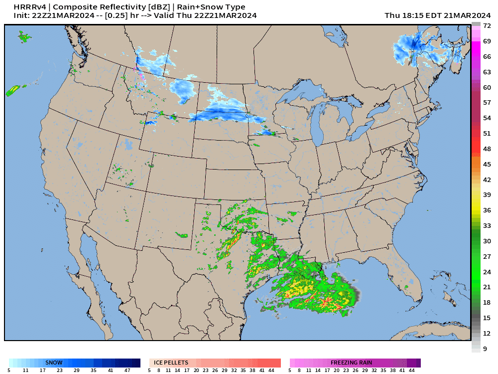
Boatloads of moisture in the Gulf of Mexico surge into the Southeast and Florida
Snowfall — heavy at times spreads over the Great Lakes
Friday High Temperatures
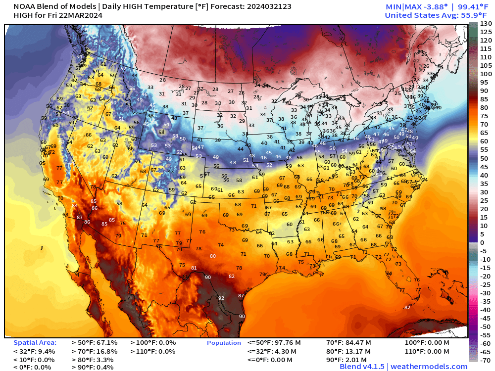
It will be cloudy and rainy across the Southeast, but still relatively mild in the 60s and 70s. Toasty 90s in South Texas.
Again, might not get much above freezing in the Midwest and Great Lakes.
Next 3 Days Weather Pattern

The rainfall up the East Coast could certainly be heavy on Saturday before turning to snow in northern New England.
The moisture from the Pacific moves across the Rockies, getting ready for the next major Spring/Winter storm in the Central Plains on Monday.

NWS snowfall amounts for the next 3-days are impressive!
Nice stripe of 12-inches+ from Montana into Minneapolis — yes that’s a 13” number — through Sunday evening 7 pm CT
Friday’s Weather

I really like these frontal maps with the weather systems from WPC. They provide the underlying GIS locations, so I may try to generate some TV style maps with moving Lows and fronts along with the model data.
South Florida ESCAPES Worst of Deluge

Blown forecast alert! Bust!
2-3” for South Florida — which is half of what forecast just yesterday. That’s a significant bust especially in the short-term.
Two blobs of heavy rain split as they approach Florida from the West, with the heaviest rain now in the Keys.
Next 8-days Weather Pattern: Legit Spring Storm Systems

Friday into Saturday: area of low pressure skirts along Gulf Coast = heavy rain for Florida, up to 2-3”. All of that moisture across the Southeast surges up the East Coast
Saturday into Monday: Another storm system landfalls the West Coast with a low pressure off Oregon bringing Pacific moisture onshore with an atmospheric river.
East Coast frontal boundary develops a low pressure system and intensifies with heavy rain in Mid-Atlantic and Northeast, and heavy snow again in northern New England.
Monday: Powerful central plains into Midwest winter storm still in the forecast with Minnesota the locus of upwards of 2-feet of snowfall.
Next Wednesday and Thursday: West unsettled again with boatloads of Pacific moisture arriving within a very chilly trough/ weather pattern, to considerable mountain snowfall.
WPC 7-Day Precipitation Forecast

Still > 2” of QPF in Minneapolis, which is welcome as this winter had a “snow hole”
That red band from Texas to the Southeast and up the East Coast is 2-3”+ of rainfall — until you get to northern New England, then it’s snow!
Ensemble 75th Percentile Snowfall 15-Days

A slightly different map: the 75th Percentile Ensemble snowfall through Day 15.
The western U.S. is crushed + northern New England.
In early April, we’ll look back and wonder what the heck happened!
Thank you to Subscribers and Supporters! Almost Spring 2024 and the growing season — so much is going on in the world of weather! Please come along for the ride!
Maps sourced from weathermodels.com
I think the study of forecast "busts" may be more useful than studying successes. More lessons learned from failures- ask civil or military aviation review boards.
Here in canada happy to see El Niño weakening, have had more moisture in Alberta last 4 weeks than previous 4 months and hope it keeps coming.
Helps if La Niña means more normal summer for us, record fire acreage burned last year, low year would be nice.