


March 21, 2024 Chilly Thursday Morning Across Midwest and Great Lakes
Ingredients in place for a weekend East Coast mess

Good morning! It’s a chilly early Spring Thursday across the Midwest and Great Lakes with temperatures mainly in the teens and lower 20s from North Dakota to Michigan including Minneapolis, Grand Rapids, and into New England.
7:00 AM ET Temperature Analysis
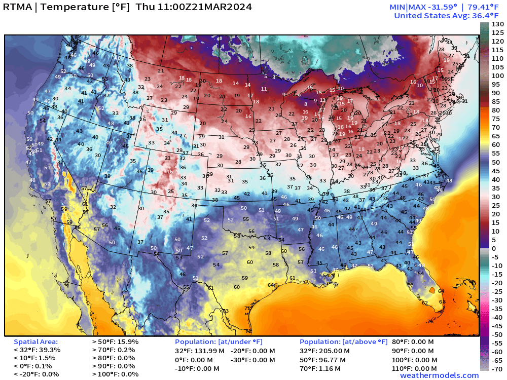
Still 132 million Americans at/below freezing at 7 AM with the only mild areas in the 60s in SW Arizona, Texas and South Florida. The Spring Fever earlier in the monthly of March is long gone across much of the Lower 48.
Today’s Weather
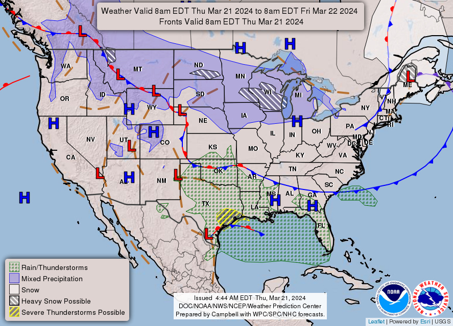
Snowfall continues this morning from Minneapolis into Milwaukee. The area of low pressure over Maine continues to spin and intensify slightly. A cold front is sagging into the Southeast but not going to spoil the beautiful weather in Atlanta.
Showers and thunderstorms — some severe around Houston — are moving into the Gulf of Mexico — to drench Florida on Friday and Saturday.

Next 18-hours Weather | Simulated Radar | HRRR
Thursday High Temperatures
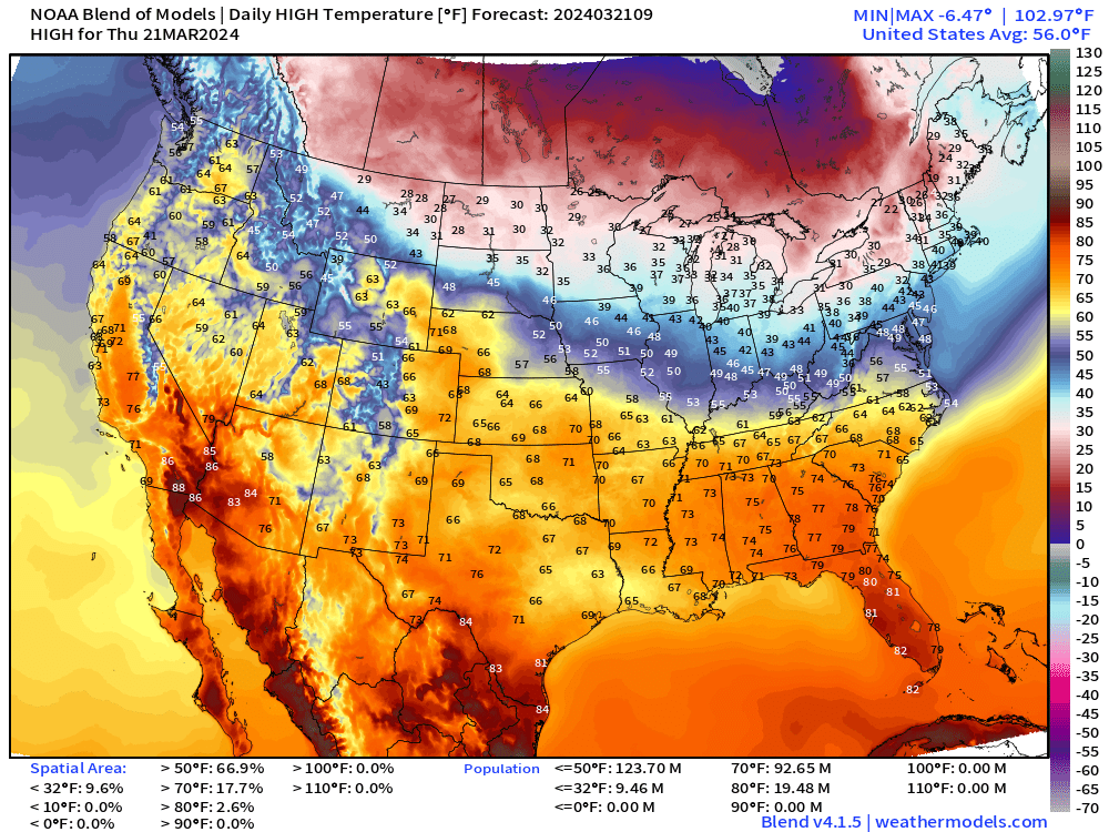
The best weather today will be in the Southeast with 70s extending from Nashville to Jacksonville, Florida. Also, beginning to heat up in the Southwest with 80s in Phoenix and Yuma.
The Midwest, Great Lakes, and New England remain around freezing or in the mid-30s for high temperatures with chances of snowfall. Another brisk early Spring day.
Next 3 Days Weather Pattern
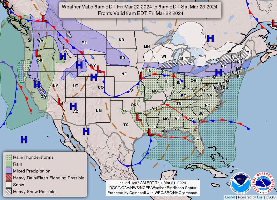
A weak disturbance extends across the Midwest into the Great Lakes with snowfall on Friday. That moisture combines with the huge slug of subtropical moisture out of the Gulf of Mexico, crossing Florida, and surging up the East Coast.
Friday’s Weather
Saturday’s Weather
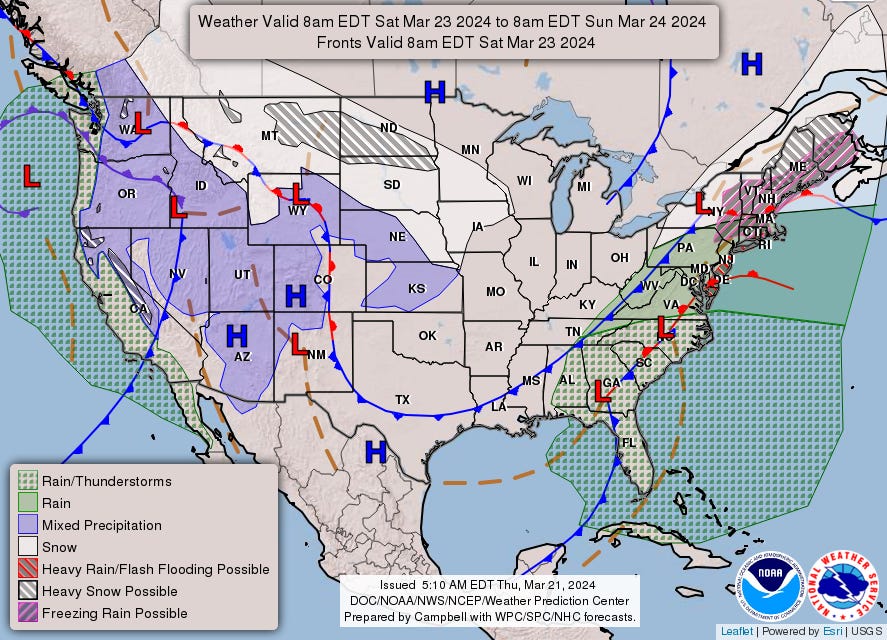
The evolution of the east coast Low Pressure is complicated with an extended frontal boundary from Florida to Maine on Saturday with major impacts.
Incredible snowfall forecast for Maine > 2-feet by Sunday.
South Florida Deluge Next 3-Days
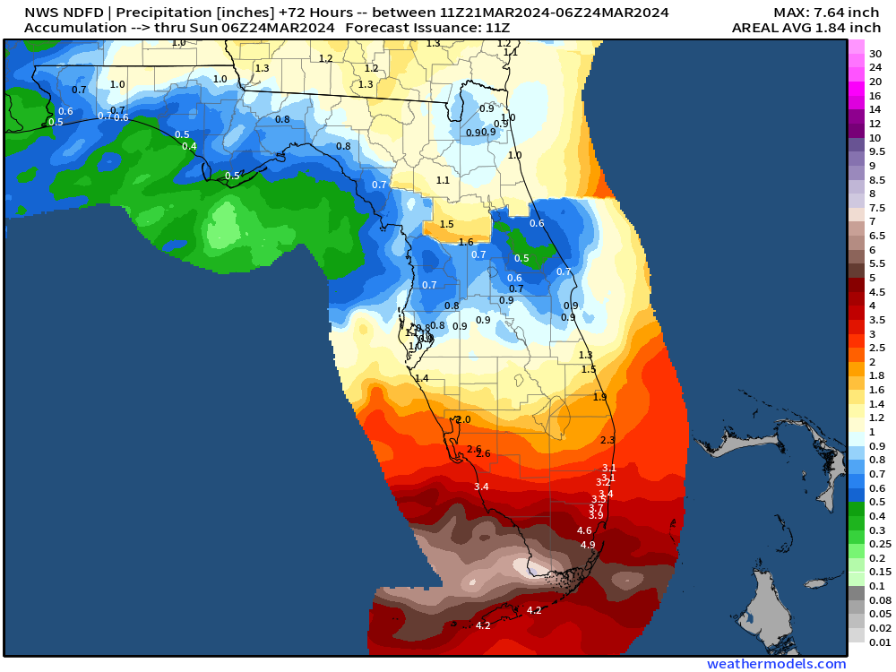
Rainfall forecast amounts have decreased this morning a little bit especially around Miami, now expected 3” to 4” rather than upwards of 6”. However, the squalls coming off the Gulf of Mexico will be localized and difficult to pinpoint exact amounts.
Next 8-days Weather Pattern: Several Storm Systems
Thursday: Low pressure system over Northeast and Maritime Canada deepens with significant snowfall in Maine into Canada.
Friday into Saturday: area of low pressure skirts along Gulf Coast = heavy rain for Florida, 3-5”. All of that moisture across the Southeast surges up the East Coast
Saturday into Monday: Another storm system landfalls the West Coast with a 996 mb low pressure off Oregon bringing Pacific moisture onshore.
East Coast frontal boundary develops a low pressure system and intensifies with heavy rain in Mid-Atlantic and Northeast, and heavy snow again in northern New England.
Monday: Powerful central plains into Midwest winter storm still in the forecast with Minnesota the locus of upwards of 2-feet of snowfall.
Next Wednesday and Thursday: West unsettled again with boatloads of Pacific moisture arriving within a very chilly trough/ weather pattern, to considerable mountain snowfall.
WPC 7-Day Precipitation Forecast
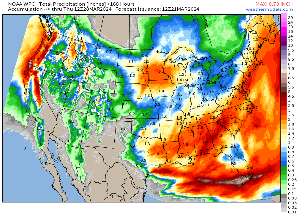
2.4” of QPF in Minneapolis = all snow? That would be in the 2-feet range.
2-3” from eastern Texas to Atlanta and up into the Mid-Atlantic and New England coast including Boston.
The heaviest rain in Florida now seems to avoid the central portions of the peninsula including Orlando.
Ensemble Median Snowfall 15-Days
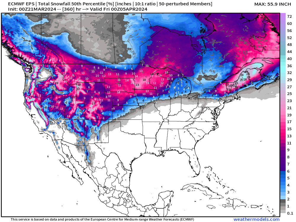


Highlight of the next 1-2 weeks will be extreme snowfall amounts in the Midwest as well as New England.
Here’s Caribou, Maine with median/mean of 21”-27” of snowfall over the next 2 weeks.
Thank you to Subscribers and Supporters! Almost Spring 2024 and the growing season — so much is going on in the world of weather! Please come along for the ride!
Maps sourced from weathermodels.com