


June 9, 2024 Tropical Update: Florida Deluge
Gulf of Mexico focus of potential tropical storm development in 7-10 days

Welcome to the 2024 Atlantic Hurricane Season | Please subscribe for $5/month for email inbox deliveries every morning — or more often as conditions warrant.
The investment in my research and development will pay off as A.I. enabled weather forecasts become a normal and indispensable part of our weather forecasting enterprise.
Gulf of Mexico area for potential tropical storm development in about 10-days from moisture plume
ECMWF AIFS modeling and EPS ensembles show significant support for 1 tropical system
The systems would battle wind shear but deliver enormous rainfall.
The atmospheric river diagnostic called Integrated Vapor Transport (IVT) works nicely in the tropics to highlight the convergence of deep tropical moisture into plumes across the Gulf of Mexico into Florida.
Next 10-days from ECMWF of IVT:

Check out the development of 2 tropical systems — or maybe 1 depending on the survival of the vorticity across Mexico from the Gulf of Tehuantepec to the Bay of Campeche.
The moisture feed out the Caribbean into the Gulf of Mexico and over Florida is plainly apparent for the next 10-days. The total precipitation for just the next 7-days is now pushing 15-inches and higher across South Florida. NOAA WPC:

Atlantic Basin Tropical Weather Outlook
No areas of interest [48-hours or 7-days] in the NHC Tropical Weather Outlook across the Atlantic tropics as we head through the 2nd week of the 2024 Atlantic Hurricane Season.
Synoptic Analysis
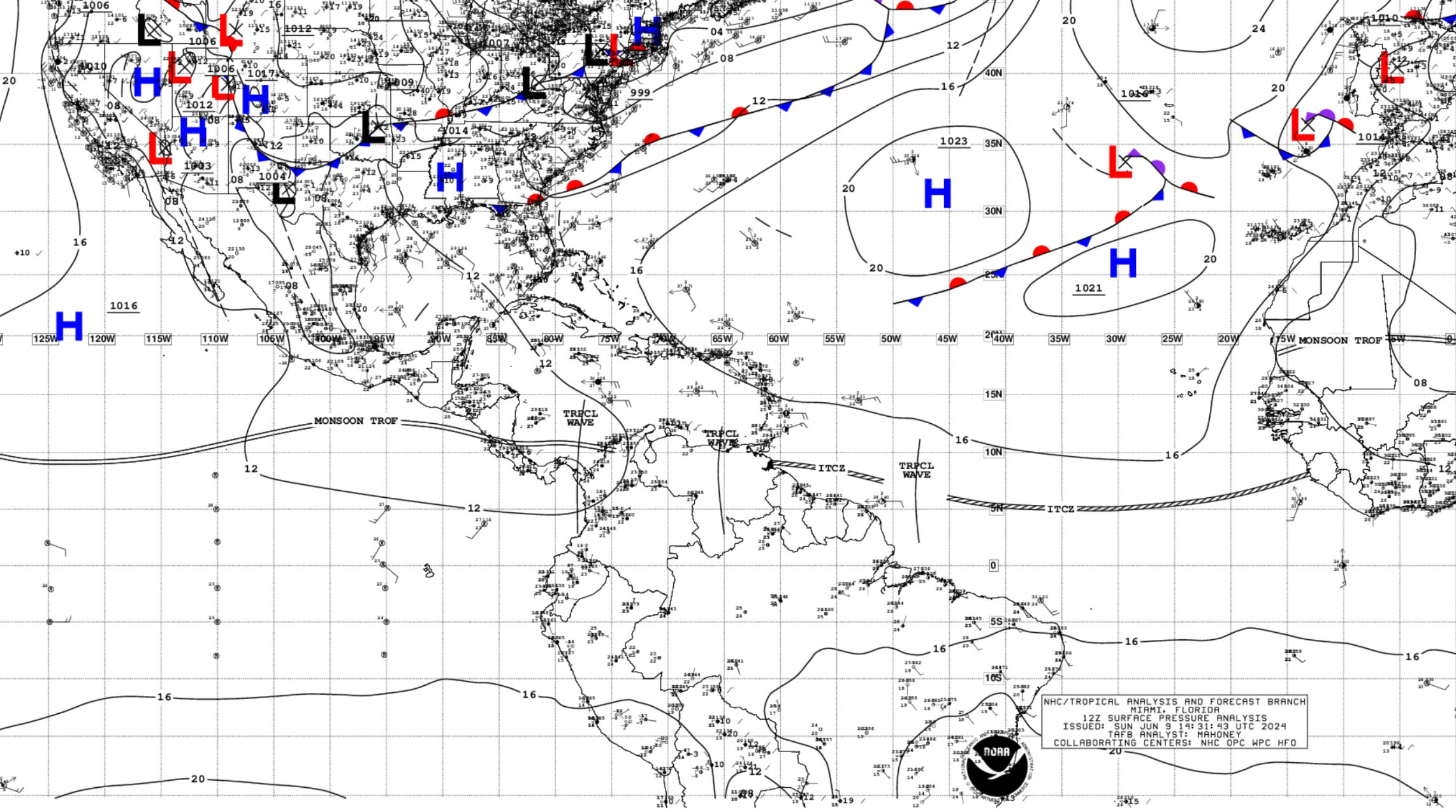
..TROPICAL WAVES...

A tropical wave is in the central Atlantic along 48W, south of
11N, and moving westward at 10-15 kt. Scattered moderate convection
is from 07N to 11N between 42W and 55W.

A tropical wave is in the SE Caribbean Sea along 65W, south of
12N, and moving westward at 10-15 kt. Scattered showers are inland
across central Venezuela.

A tropical wave is stalled in the SW Caribbean Sea along 78W,
south of 14N. Scattered moderate convection is from 09N to 13N
between 75W and 83W, including coastal regions of Panama and
Colombia.
Basin Wide Infrared Satellite Imagery

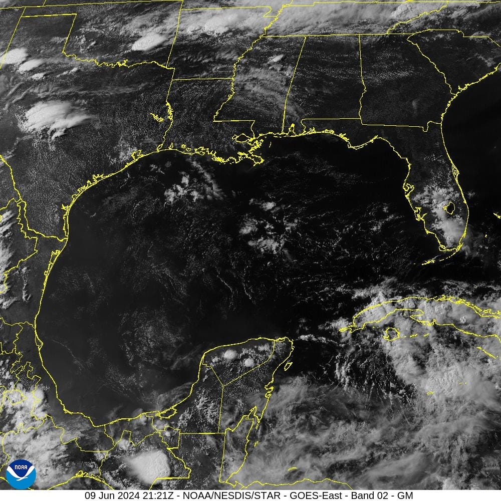
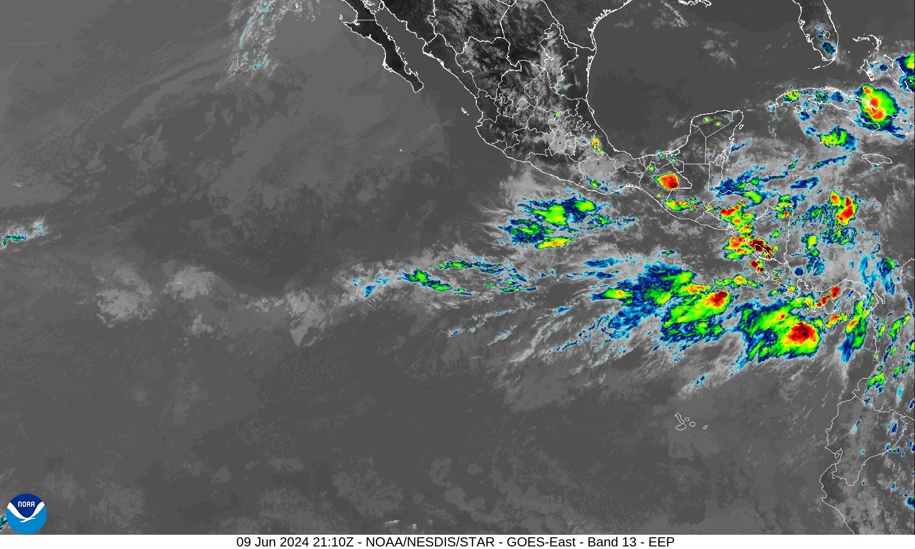
Gulf of Mexico
Precipitation Anomaly Next 10-days
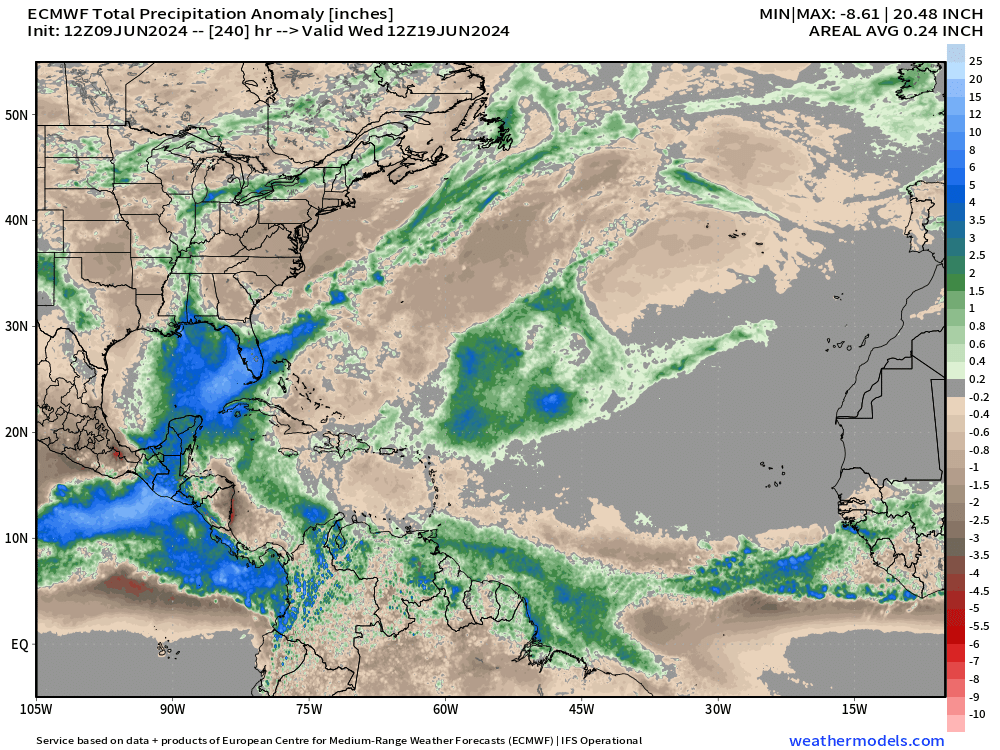
Gulf of Mexico the focus of exceptional rainfall over the next 10-days associated with tropical moisture feed (atmospheric river)
[Convection or heavy rain and storms occur in paths or tracks with or w/o organized tropical cyclones. Where it rains is the obvious footprint or evidence of where ascent, instability, and potential for development could/might occur in a 10-day period from a weather model. This is an easy way to eyeball where/if TCs will occur.]
ECMWF IFS | 10-Day Precipitable Water Anomaly Forecast
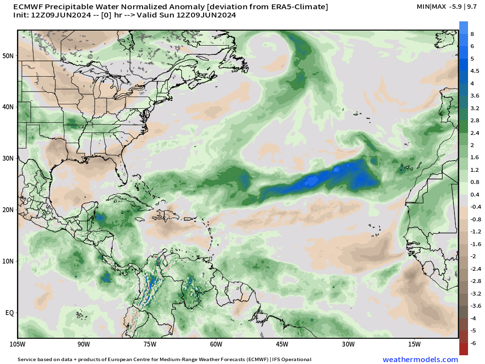
At the end of the 10-day loop, we can see a bit of a swirl in the southern Gulf of Mexico with moisture arriving from a tropical wave way back in the Main Development Region (MDR). The moisture plume is massive moving into the central Gulf of Mexico.
That’s our best chance of a tropical storm so far in 2024 — but plenty of waiting and watching.
[This is the “normalized anomaly” of precipitable water (my favorite variable) taking into account climatology (30-years) and calculating deviations from the historical mean. This allows easy tracking of extreme features like the tropical wave in the eastern Atlantic. The dry air with the late-season cold front is highlighted by this weekend.]
10-Day | Atlantic EPS Cyclone Tracks
Many ensemble members [majority] now show the development of a tropical system in the Caribbean gyre in the 10 day time frame.

Again we need to use MSLP normalized anomalies to highlight the pressure deviation from the background model climatology.
At Day 10, we can then see the systems much better. However, even with the extreme deviation e.g. -7 sigma, the variance is tiny in the daily tropical MSLP field so do not be alarmed. We barely have closed MSLP contours.
Nevertheless, out of the 50-ensembles, your eye can see over half with a tropical system. I should probably automate this somehow.


Eastern Pacific Tropical Weather Outlook
New note: Potential close-to-land development in the Gulf of Tehuantepec by next weekend according to ECMWF IFS.
NHC does not have any areas of interest in the Tropical Weather Outlook through 48-hours and 7-days — June 14.
June can be quiet busy in the Eastern Pacific as the Caribbean gyre spawns vorticity + tropical waves reach the very warm waters west of Central America.
However, the convection associated with the waves has remained weak and unable to persist — so far evidence of a quiet season due to transition to La Nina.
ECMWF HRES 10-Day Storm Tracks

Watching Central America including the EPAC/Gulf of Mexico for close-to-land developments in the Caribbean Gyre.
ECMWF AIFS 15-Day Storm Tracks

ECMWF AIFS Tropical Storm candidate:
We lost the near-term system in the Gulf of Mexico predicted a couple days back for mid-week.
Using the MSLP normalized anomaly, we can see the surface pressure depressions associated with tropical waves and potential tropical storms.
While not intense — there is a bias in the surface pressure of tropical cyclones in the AIFS — there is 1 potential system in the Gulf of Mexico at Day 10.
Wednesday June 19: +10 days from 12z AIFS


The system is rather large and diffuse but shows up as a significant pressure depression. However —>
We really have no idea about the tropical cyclone genesis bias or hit-rate or skill — so all we can do is watch the model data on a day to day basis to learn.
Western Pacific Tropical Weather Outlook

Ghost town — No Suspect Areas areas of interest during the next 48-hours to 7-days from JTWC.
ECMWF EPS ensembles not even showing a hint of TC genesis for next 10-days.

Thank you to Subscribers and Supporters! Welcome to June 2024 and Atlantic Hurricane Season.
Maps sourced from weathermodels.com designed and innovated by yours truly! I actually create all of my content from scratch.