


June 25, 2025 Hurricane Season Wednesday
Atlantic remains quiet while we wait on Flossie in Pacific

2025 Atlantic Hurricane Season [Day 25]. My expectation for this year is 14 named storms, 7 hurricanes, and 3 majors. So far, 1 named storm, 0 hurricanes, and 0 majors.
Wednesday’s Tropical Update
Atlantic Basin: Saharan Dust Layers might be the only interesting large scale feature for the next 5-7 days
Eastern Pacific Basin: Invest 95E is still expected to become Flossie in 3-4 days, but the process is really slow — NHC at 80% in 7-days.
Western Pacific Basin: TD 03W was designated near SE China but won’t become a storm, so the next system will get the name Mun — perhaps a Typhoon out of the monsoon trough in 5-7 days.
Lows for Wednesday Morning

Finally relief in New England with much cooler air from the Atlantic
Wednesday High Temperatures

Still in the 90s for Chicago, Detroit, to D.C. and points south, but noticeably cooler in NYC, Boston and New England in the 70s and 80s.
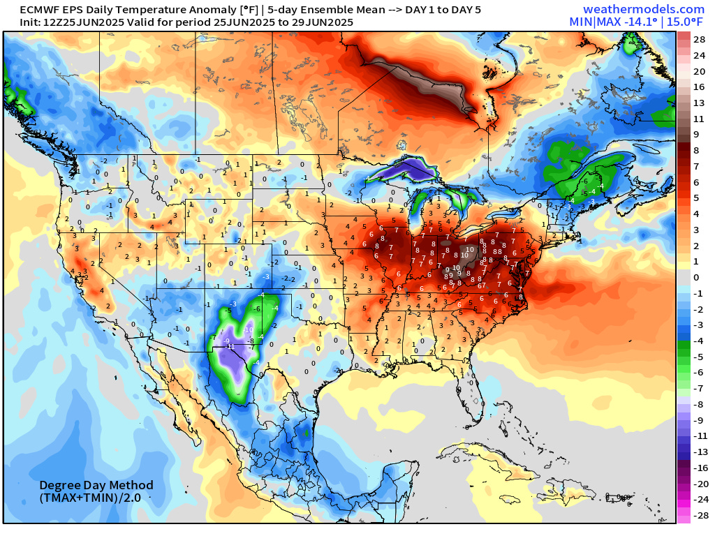
5-Day Temperature Anomaly Chunks | ECMWF Ensemble Mean 12z | Next 15-days check on Lower 48 Temperatures (Energy concerns)
Days 1-5: June 25-29
Days 6-10: June 30 - July 4

Days 11-15: July 5 - 9

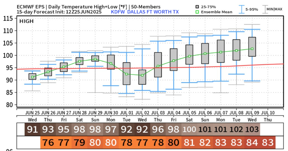
Watching Texas for extreme heat … the ensembles are not all on board, yet, but the HRES shows 105°F to 109°F for highs in Dallas for July 5th onward.

NWS WPC Precipitation Next 7-days

Texas with a bit of a rain hole in the center of the state … healthy rainfall totals for the Midwest, Mid-Atlantic into Northeast, and Florida.
ECMWF 12Z | Integrated Vapor Transport | Next 10-days

High pressure slides westward in the SW Atlantic pushing moisture from the ocean onshore into the Southeast raising the rain/storm chances considerably — and busting the heat wave.
The surge of Caribbean tropical moisture continues but there are some breaks in the intensity due to Saharan Air Layer (SAL) influence.
Flossie is STILL expected to form and parallel the Mexico coast into the weekend, and head to Baja California in 7-8 days.
Thank you to readers continuing into this Hurricane Season. My goal is to keep you informed about ongoing extreme weather events inside and outside of the tropics, but also a week (hopefully) heads up on what’s coming. I’ll be using a variety of weather modeling output, some of it may be unfamiliar, but it’s state-of-the-art and industry leading standard.
No tropical cyclone formation likely in the Atlantic basin in the next 7 days+
Keep reading with a 7-day free trial
Subscribe to Weather Trader to keep reading this post and get 7 days of free access to the full post archives.