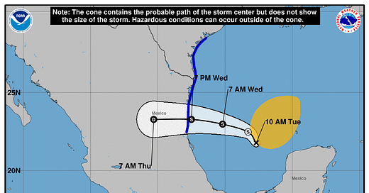
June 18, 2024 Tropical Update: Potential Tropical Cyclone 01L
Waiting on Alberto but it is slow going in the southern Gulf of Mexico
Headlines for Tuesday
Now 3 areas of interest in the Atlantic: southern Gulf of Mexico and off the SE U.S. coastline — still waiting on Alberto [and Beryl] No activity in the Eastern Pacific so far in 2024 — unusual. The Western Pacific is also a ghost town.
Potential Tropical Cyclone (01L) is forecast to become Alberto in the next 24-hours assuming a low-level center of circulation is found by aircraft recon or seen on satellite. Right now, the system is part of the large gyre.
A Central American Gyre (CAG) continues to rotate deep tropical moisture out of the Caribbean into the Gulf of Mexico and will drive the weather for the next 7-10 days with another chance of storm development next week (20% chance).
The CAG will help fuel the development of the “heat dome” or downstream ridge.
Keep reading with a 7-day free trial
Subscribe to Weather Trader to keep reading this post and get 7 days of free access to the full post archives.


