June 16, 2024 Tropical Update: Central American Gyre
Central American Gyre may spawn a tropical cyclone in the southern Gulf of Mexico
Two areas of interest in the Atlantic in the southern Gulf of Mexico and off the SE U.S. coastline — still waiting on Alberto and Beryl.
A Central American Gyre has formed and will drive the weather in the Caribbean and Gulf of Mexico for the next 7-10 days. Texas and the Gulf Coast into Louisiana will be drenched with excessive/flooding rain.
A massive, long-lasting and potentially record setting June heat dome is building over the Northeast and Mid-Atlantic in response to a trough digging out west.
The ridge will force a tropical moisture plume from the “gyre” to go around to the north and provide the Midwest — especially Minnesota with boatloads of rain.
First area being watched in the 48-hour and 7-day range in the southern Gulf of Mexico for likely tropical cyclone development: 50% to 70%
1. A large area of disturbed weather is located over Central America, the Yucatan Peninsula of Mexico, and the adjacent waters of the northwestern Caribbean Sea and southern Gulf of Mexico.

A broad area of low pressure is forecast to form from this system over the
southwestern Gulf of Mexico within the next day or so.

Environmental conditions appear conducive for subsequent gradual
development of the low, and a tropical depression or tropical storm
is likely to form by midweek while it moves slowly westward or
west-northwestward toward the western Gulf coast.

* Formation chance through 48 hours...medium...50 percent.
* Formation chance through 7 days...high...70 percent.
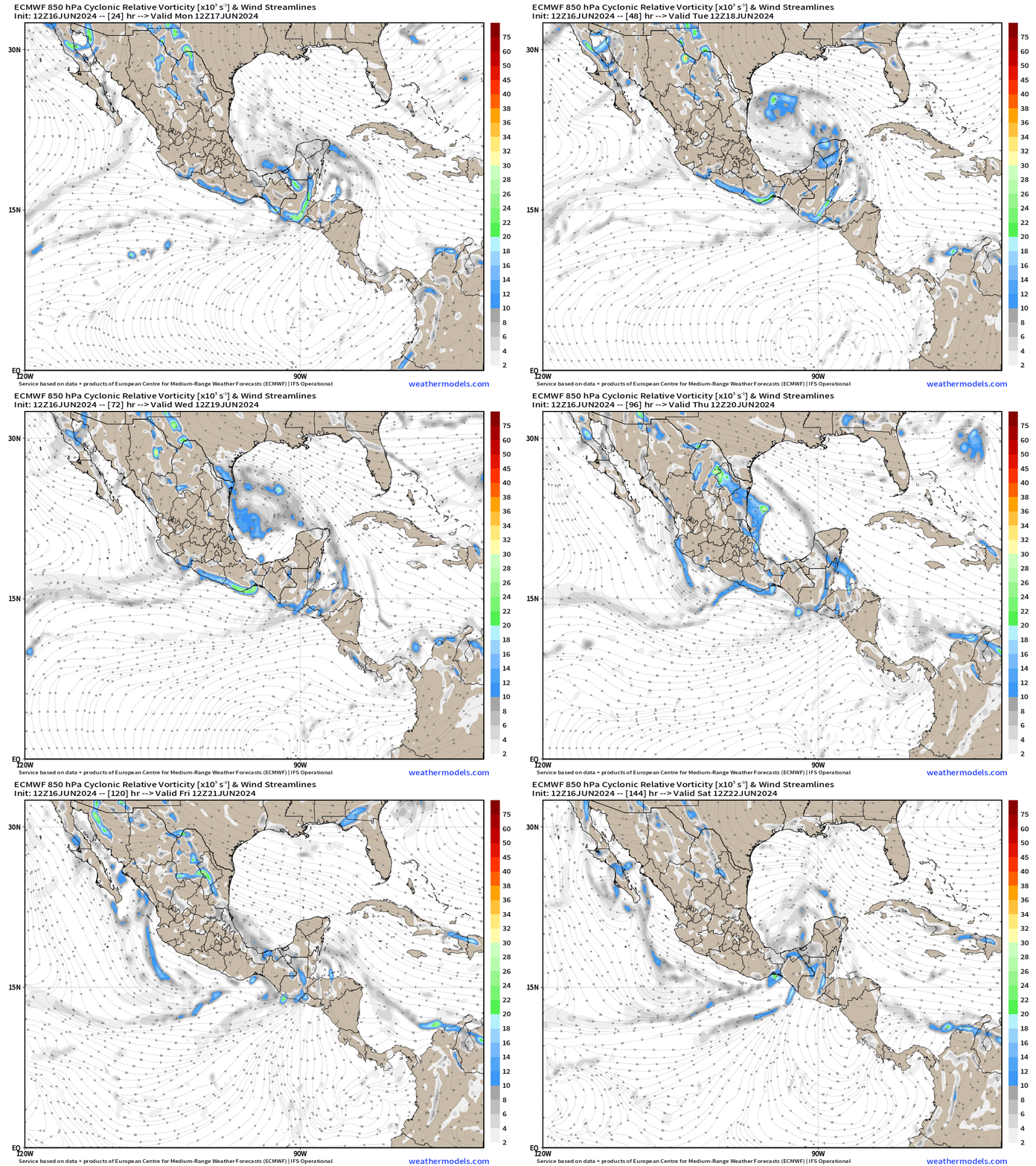
Central American Gyre
The relative vorticity at 850 hPa (low-levels) highlights the “spin” or convective elements over and around Central America aided by “gap flow” through the Gulf of Tehuantepec. This allows the transport of deep tropical moisture from the Eastern Pacific into the Gulf of Mexico — the opposite situation when cold fronts from the north during winter typically blast cold, dry air into the Pacific from the Gulf of Mexico.
Note the little blob arriving in north Florida from the Atlantic by late Thursday. That may provide enough of a spin and convection for a weak TD or TS, but the way this season is going so far, I’d not bet much.
Weather Trader is a reader-supported, daily newsletter. To receive new posts and support our R&D, consider becoming a free or paid subscriber.
10-Days Integrated Vapor Transport
The atmospheric river diagnostic called Integrated Vapor Transport (IVT) works nicely in the tropics to highlight the convergence of deep tropical moisture into plumes.
Next 10-days from ECMWF of IVT:
Southern Gulf of Mexico system (Mon-Tues): 70% chance
Tropical wave arriving into North Florida (Thursday): 30% chance
Heavy rain on the western side of the Heat Dome in the Upper Midwest
Synoptic Analysis [June 16, 2024 18Z]
Heavy Rainfall over Central America and Mexico, and gale warning over the Gulf of Mexico:

A broad area of low pressure is centered over northern Central America and southern Mexico. Environmental conditions over the SW Gulf appear conducive for subsequent gradual development of the low, and a tropical depression or tropical storm could form by midweek while it moves slowly W or WNW.

This weather pattern is known as a Central American Gyre (CAG),
and often persists for several days.
2 TROPICAL WAVES...

The axis of an eastern Atlantic tropical wave is near 25W, from
15N southward, moving westward around 10-15 kt. No significant
convection is evident near the wave.

The axis of a central Atlantic tropical wave is analyzed near
57W, extending from 16N southward. It is moving west at 10-15 kt.
Scattered moderate convection is from 06N to 16N between 50W and
55W.
Basin Wide IR Satellite Imagery
Note the thick sand/dust plume with a new strong SAL / African dust layer coming off the continent — reference NASA GEOS5 dust extinction.
Saharan Dust Layer Next 10-days
The Saharan Air Layer with African Dust will continue to shroud the central Tropical Atlantic in the Main Development Region putting a lid on tropical development.
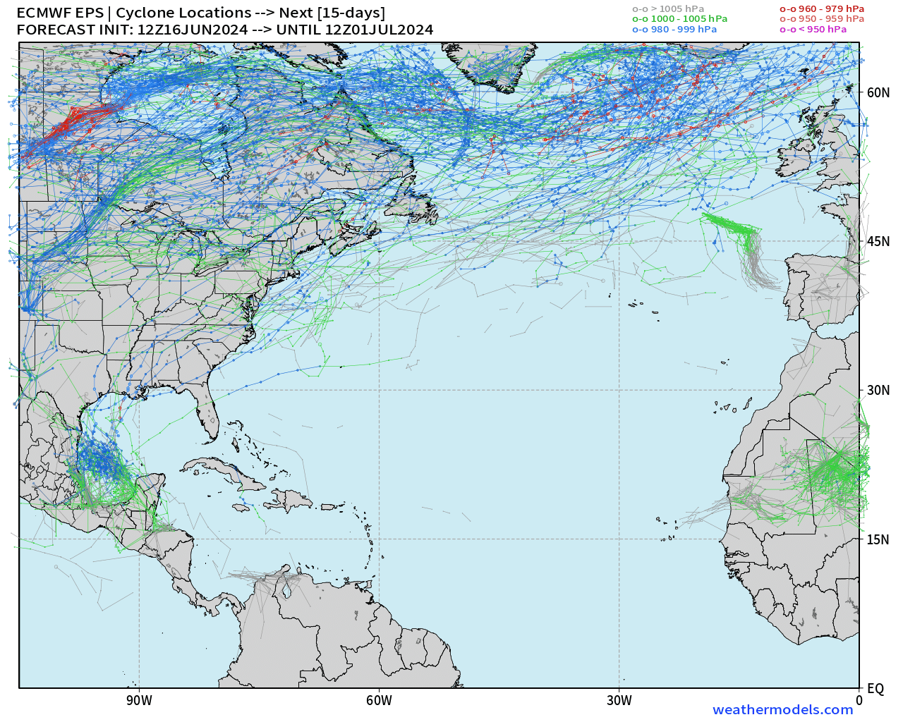
Next 15-Days EPS Ensemble Tropical Storm Tracks
Only show in town is the Gulf of Mexico during the next 15-days.
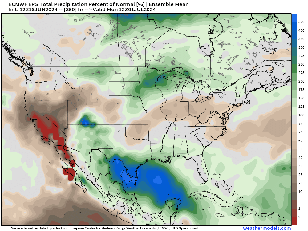
Precipitation Anomaly Next 15-days [inch]
The Gulf of Mexico is the focus of exceptional rainfall over the next 10 to 15-days associated with tropical moisture feed on periphery of the gyre. Dry across the Ohio Valley.
NOAA WPC Precipitation Next 7-days
Scant rainfall under the heat dome over the next 7-10 days.
Enormous rainfall totals for the Texas Gulf Coast but also up to 5” into San Antonio. All of this rainfall is VERY welcome across the Lone Star State.
Wow — check out all of the rain across Minnesota! 6 Trillion gallons total.
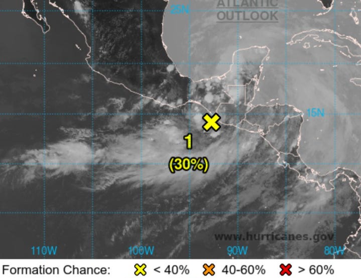
Eastern Pacific Tropical Weather Outlook
1. Offshore Central America (EP90): 30% chance

A small area of low pressure located just offshore and to the south
of the Guatemala/Mexico border is producing disorganized showers
and thunderstorms.

Environmental conditions appear conducive for
slight additional development before the system moves inland
tonight or early Monday.

* Formation chance through 48 hours...low...30 percent.
* Formation chance through 7 days...low...30 percent.
Otherwise, the 15-day Ensembles from ECMWF are almost a blank slate for developing tropical cyclones. Amazingly quiet until the end of June.
NHC has Invest 90E as the area of interest [30%]
June is usually a busy month in the Eastern Pacific, but not this year — yet to see a named tropical storm.
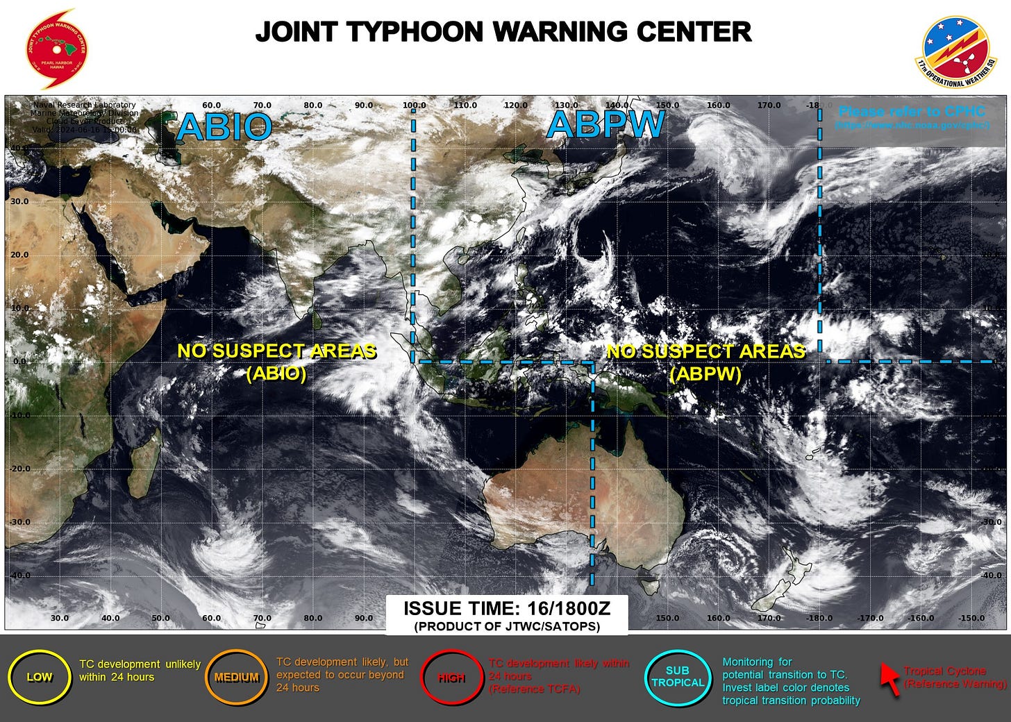
Western Pacific Tropical Weather Outlook
Ghost town — No Suspect Areas areas of interest during the next 48-hours to 7-days from JTWC.
ECMWF EPS ensembles show a few members with a hint of a TC track over the next 10-days in the South China Sea. The last week of June could see development east of the Philippines.
Thank you to Subscribers and Supporters!
The investment in my research and development will pay off as A.I. enabled weather forecasts become a normal and indispensable part of our weather forecasting enterprise.
Maps sourced from weathermodels.com designed and innovated by yours truly! I actually create all of my content from scratch.


