


June 15, 2024 Tropical Update: Gulf of Mexico
Developing Central American Gyre may spawn a tropical storm in the southern Gulf of Mexico

Invest 90L is gone fishing in the Atlantic and no longer a concern for tropical storm development. Focus has shifted almost entirely to the southern Gulf of Mexico for the development of a system next week within the Central American Gyre.
The EPS Ensembles show a variety of potential tracks dependent upon the random convective elements within the gyre rotating counter-clockwise.
Heavy rain will inundate much of the western Gulf of Mexico with significant impact to Texas.

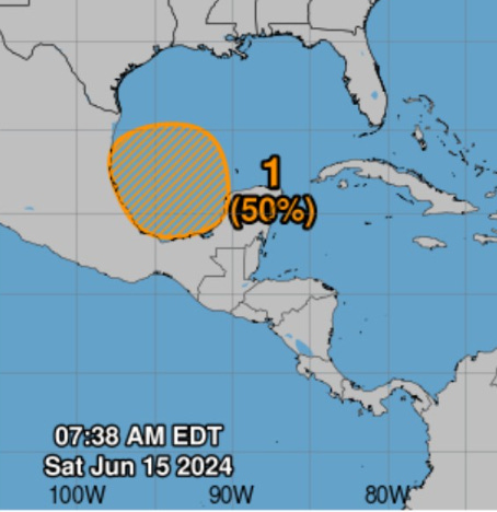
Area being watched in the 7-day range in the southern Gulf of Mexico for gradual tropical cyclone development: 50%
1. Southwestern Gulf of Mexico:

A broad area of low pressure is forecast to form over the SW Gulf of Mexico early next week. Environmental conditions appear conducive for gradual development of this system, and a tropical depression could form by the middle part of next week while the system moves slowly W or WNW.

Regardless of development, locally heavy rains area likely to
occur over portions of southeastern Mexico and Central America
during the next several days.

* Formation chance through 48 hours...low...near 0 percent.
* Formation chance through 7 days...medium...50 percent.
Central American Gyre

The relative vorticity at 850 hPa (low-levels) highlights the “spin” or convective elements over and around Central America aided by “gap flow” through the Gulf of Tehuantepec. This allows the transport of deep tropical moisture from the Eastern Pacific into the Gulf of Mexico — the opposite situation when cold fronts from the north during winter typically blast cold, dry air into the Pacific from the Gulf of Mexico.
ECMWF 00Z (HRES) showed one rather weak center of low-pressure and vorticity swinging into northern Mexico.
Note the little blob arriving in north Florida from the Atlantic by late Thursday. That may provide enough of a spin and convection for a weak TD or TS, but the way this season is going so far, I’d not bet much.
Weather Trader is a reader-supported, daily newsletter. To receive new posts and support our R&D, consider becoming a free or paid subscriber.
Keep reading with a 7-day free trial
Subscribe to Weather Trader to keep reading this post and get 7 days of free access to the full post archives.