


June 12, 2025 Hurricane Season Thursday
Next system in Eastern Pacific will be named Dalila and could reach hurricane intensity

2025 Atlantic Hurricane Season [Day 12]. My expectation for this year is 14 named storms, 7 hurricanes, and 3 majors. So far, 0 named storms, 0 hurricane, and 0 majors.
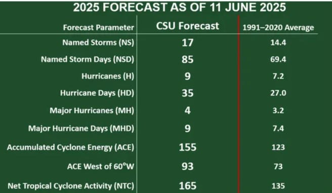
Colorado State University updated their seasonal forecast for June 11, 2025, but didn’t change the headline numbers of 17/9/4 with ACE of 155. My expectations are lower based upon significantly cooler water in the central tropical Atlantic unfavorable upper-level winds consistent with a more “Nino-like” Pacific horseshoe SST pattern.
Thursday’s Tropical Update
Atlantic Basin: No areas being watched through the next 7-days (June 19) by NHC and the ECMWF ensembles are blank for next 2-weeks.
Eastern Pacific Basin: A new system is forming for this weekend (04E —> Dalila)
Western Pacific Basin: Wutip (01W) is the basin’s first tropical storm and is heading to southern China perhaps as a strong TS or minimal Typhoon.
Thank you to readers continuing into this Hurricane Season. My goal is to keep you informed about ongoing extreme weather events inside and outside of the tropics, but also a week (hopefully) heads up on what’s coming. I’ll be using a variety of weather modeling output, some of it may be unfamiliar, but it’s state-of-the-art and industry leading standard.
ECMWF 00Z | Integrated Vapor Transport | Next 8-days

Strong easterly flow continues with increasing IVT piling up across the Lesser Antilles into the Caribbean and then into the western Gulf of Mexico — all steered by the strong, persistent subtropical high / ridge anchored over Bermuda and the Azores in mid-June.
The middle latitudes are active with storm systems and troughs dipping into the Midwest, Great Lakes and Northeast grabbing this tropical moisture and firing thunderstorms and heavy rainfall — typical of early Summer pattern. This is not a favorable upper-level situation for development of a “heat dome” instead a highly progressive / rapidly changing pattern.
Eastern Pacific: At least 1 more storm / hurricane (Dalila) in 7-days [NHC at 90%], and then another area of disturbed weather to its east by June 18-20 (10-20%)
No tropical cyclone formation likely in the Atlantic basin in the next 7-10 days+
Tropical Atlantic | Precipitation and MSLP Next 10-days
Keep reading with a 7-day free trial
Subscribe to Weather Trader to keep reading this post and get 7 days of free access to the full post archives.