


June 10, 2025 Hurricane Season Tuesday
Barbara and Cosme to weaken rapidly. Atlantic quiet for next 1-2 weeks.

2025 Atlantic Hurricane Season [Day 10]. My expectation for this year is 14 named storms, 7 hurricanes, and 3 majors. So far, 0 named storms, 0 hurricane, and 0 majors.
Tuesday’s Tropical Update
Atlantic Basin: No areas being watched through the next 7-days (June 17) by NHC and the ECMWF ensembles are blank for next 2-weeks.
Eastern Pacific Basin: Barbara (02E) and Cosme (03E) will reach cooler water and rapidly weaken. Another system organizes this weekend to the ESE along the southern Mexico coast, and should become a hurricane.
Western Pacific Basin: Invest 92W likely to become the basin’s first named tropical storm in next 24-hours as a low-level circulation consolidates within a large area of convection in the South China Sea.
Thank you to readers continuing into this Hurricane Season. My goal is to keep you informed about ongoing extreme weather events inside and outside of the tropics, but also a week (hopefully) heads up on what’s coming. I’ll be using a variety of weather modeling output, some of it may be unfamiliar, but it’s state-of-the-art and industry leading standard.
ECMWF 00Z | Integrated Vapor Transport | Next 8-days
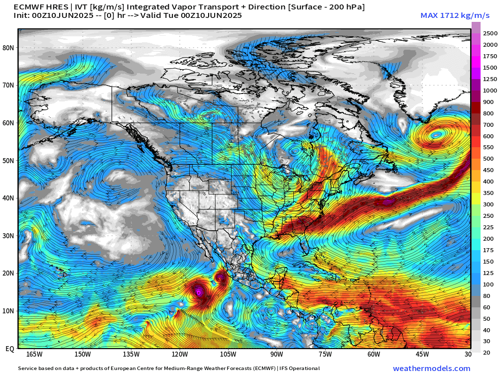
Moisture streams through the Caribbean and turns north around the strong subtropical high anchored off the U.S. East Coast. That high breaks down with a series of Canadian troughs / fronts allowing even more transport by middle of next week into Texas and the Plains + Mississippi River Valley = heavy rainfall continues. However, no trigger for tropical cyclogenesis is apparent on the Atlantic side (Caribbean and Gulf).
However, tropical waves that skirt through the Caribbean and northern South America take advantage of the warm water and low wind shear south of Mexico in the Eastern Pacific.
Eastern Pacific: At least 1 more storm / hurricane (Dalila) in 7-days [NHC at 70%], and then another area of disturbed weather to its east by June 18-20.
No tropical cyclone formation likely in the Atlantic basin in the next 7-10 days+
Precipitable Water Next 5-days | Atlantic Basin | ICON 06z
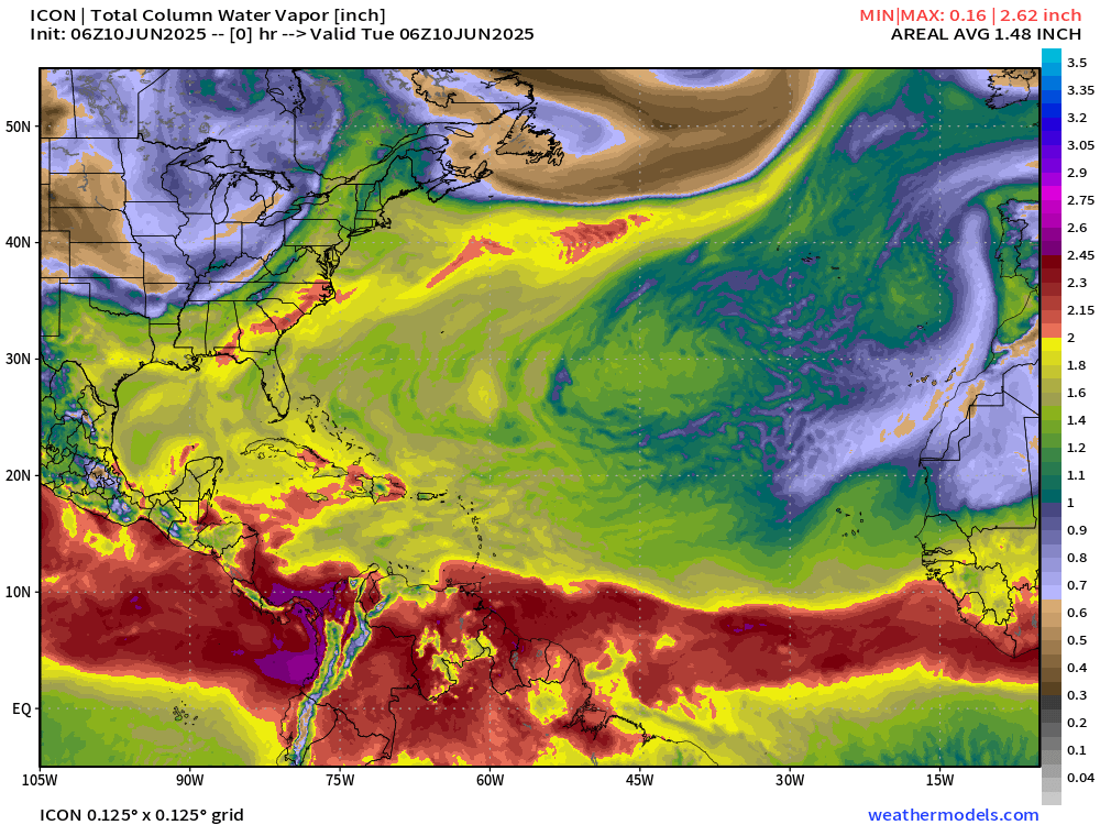
We need > 2” PWAT to fire up a tropical storm or a hurricane.
PWAT remains mostly under 2” in the Gulf and Caribbean w/o a trigger for tropical cyclone development. The ITCZ/monsoon trough is flat with a sharp gradient south of the Saharan Air Layers, but some breakdown by Day 5 in the central Atlantic as the subtropical high weakens.
Tropical Atlantic | Precipitation and MSLP Next 8-days
Keep reading with a 7-day free trial
Subscribe to Weather Trader to keep reading this post and get 7 days of free access to the full post archives.