


July 3, 2024 Tropical Update: Will Beryl Impact Texas?
Concerning northward model trend increases threat to Texas

Headlines
Major Hurricane Beryl continues to be resilient against westerly shear as it nears Jamaica at Category 4 intensity (125-knots) The maximum intensity should remain at Category 4 or high-end Cat 3 as it impacts Jamaica.
The track forecast is quite uncertain, more than usual in the southern Gulf of Mexico with some models showing more northward motion toward Texas. Therefore, while the official NHC track forecast landfalls Mexico now on early Monday — as the forward motion is slower — this is still up for revision in the next 24-48 hours. We must still watch / wait for potential Texas impacts, which could be significant. The 12z model suite update will be very informative and help decision-makers in Texas prepare this weekend.
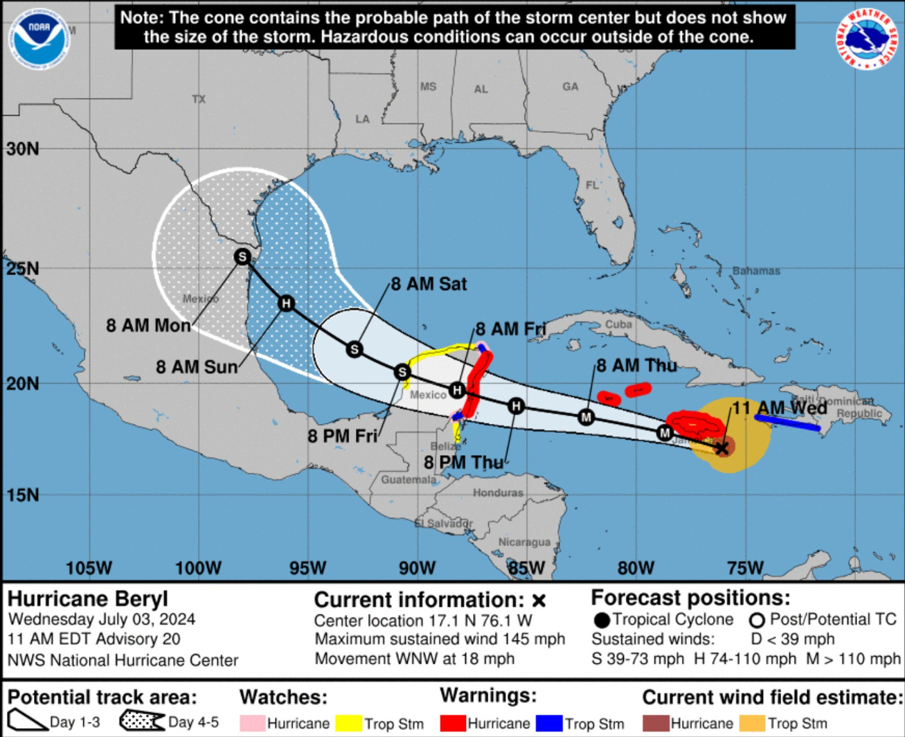
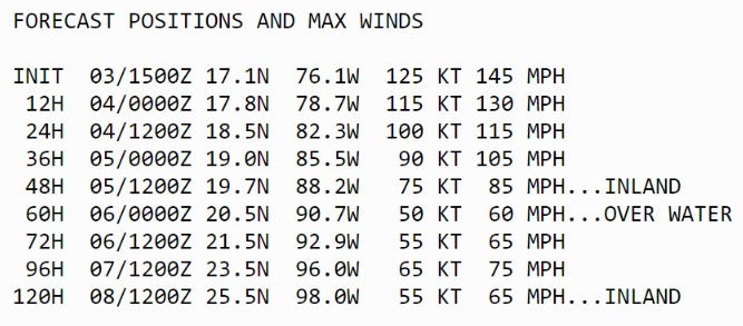
NHC Track Discussion (11 AM)
Once over the Gulf [of Mexico], there remains a sizable amount of spread in the track guidance, with the GFS and HWRF showing a more northerly motion toward the Texas coast while the ECMWF and UKMET show a more westerly motion toward the coast of Mexico.

This part of the track forecast lies near the consensus models in the middle of the guidance envelope, and overall there are no significant changes to the forecast from the previous advisory.
NHC Intensity Discussion (11 AM)
While there is some disagreement in how much shear Beryl will encounter before reaching Yucatan, the intensity guidance expects enough shear that it agrees on steady weakening.

The official forecast follows this and is at the high end of the guidance envelope.

Beryl should weaken more while over Yucatan, then slowly re-intensify over the Gulf of Mexico in a somewhat more favorable  environment.  The intensity forecast again calls for the cyclone to regain hurricane strength before it reaches the western Gulf coast, followed by weakening after landfall.
Wind Shear not yet taking a toll


My hypothesis is that the relative shear felt by the vortex is not taking a toll on Beryl because of the rapid enough translation speed or movement to the WNW at about 20 mph embedded in the lower-level 850-hPa flow in the same direction. The upper-level at 200 hPa shows weak winds consistent with an anti-cyclone providing ventilation aloft. The ocean temperatures and heat content remains exceptional providing the vigorous convection necessary to maintain the Category 4 intensity.
Jamaica Landfall?
The HAFS A-B mesoscale models show the center or eye of Beryl intersecting the coastline of southern Jamaica later on Wednesday. The definition of landfall may be satisfied if the center where the lowest pressure exists intersects the coastline.


Weather Trader is a reader-supported, daily newsletter. To receive new posts and support our R&D, consider becoming a free or paid subscriber.
Texas Impacts?
Updated 00z and 06z model guidance: GFS, GEFS, HWRF, and GEPS still show a northward curve in the Day 4-5 range with a slowing of forward speed.
The HAFS mesoscale models are to the left of the NHC official forecast, which splits down the middle, but we shouldn’t focus exactly on that middle track point.
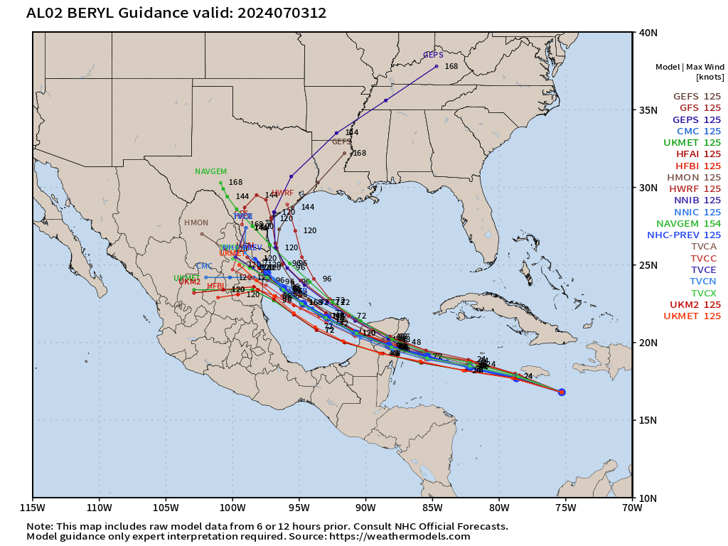
Compared to 00z, there are a lot more 06z ECMWF ensembles (out of a total of 51) that curve northward into Texas. These are more intense solutions e.g. deeper low pressure because the intensity and track are often highly correlated.
As mentioned by NHC, the GFS 06z model shows a stalling and northward turn of Beryl into south Texas. I won’t say the H storm from 2017, but we should be cognizant of all scenarios and eliminate them as soon as we can.

Verdict on Texas landfall?
Too soon to discount the possibility as a sizable chunk of the Texas coastline remains in the cone at Day 5. % —> Coin flip
Basin Wide IR Satellite Imagery
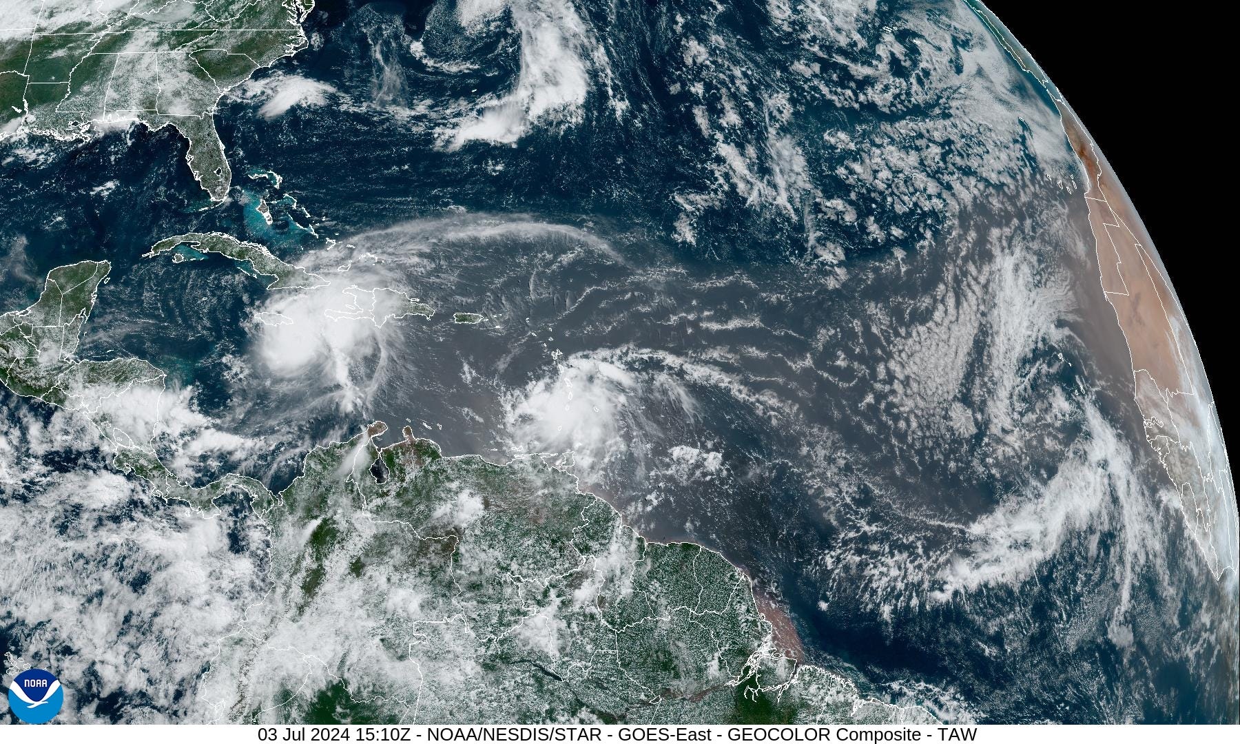
Invest 96L is now moving through the Windward Islands but has a very low chance of further development (20%)
A large Saharan dust layer is emerging again into the far eastern Atlantic. While the dust itself isn’t enough to kill development, the overall environment becomes unfavorable for the next 2-4 weeks.
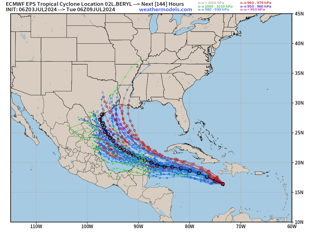
Next 15-Days EPS Ensemble Tropical Storm Tracks
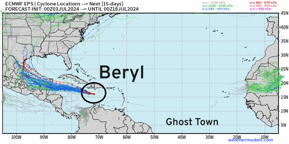
After Hurricane Beryl is finally ended likely in Texas or Mexico, no other Atlantic tropical storm activity is expected through mid-July, until the 18th at least. Ghost town for all of July?
These maps show the ensemble tracks from 51 versions of the ECMWF model — solutions to show uncertainty or variability in medium and longer range forecasts. This does not mean there are 20 tropical storms at the same time.
NASA Saharan Air Layer | African dust Forecast | 10 days

A lot more dust is on the way more typical of July across the Atlantic, suggesting the Atlantic will struggle thermodynamically to develop tropical systems. This is typical for July in the Atlantic.
Eastern Pacific Tropical Weather Outlook
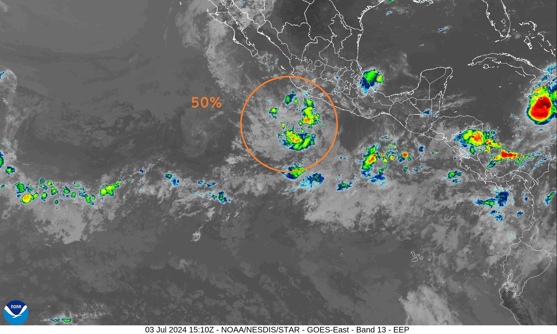
NHC outlook: a short-lived tropical depression could form within the next day 50% chance of development
Western Pacific Tropical Weather Outlook
No development expected in the next 48-hours to 7-days.
June was as dead as a doornail and July continues that trend.
Thank you to Subscribers and Supporters!
The investment in my research and development will pay off as A.I. enabled weather forecasts become a normal and indispensable part of our weather forecasting enterprise.
Maps sourced from weathermodels.com designed and innovated by yours truly! I actually create all of my content from scratch.