July 22, 2020 Tropical Update
Tropical Depression 08L in the Gulf of Mexico and Gonzalo slowly intensifying
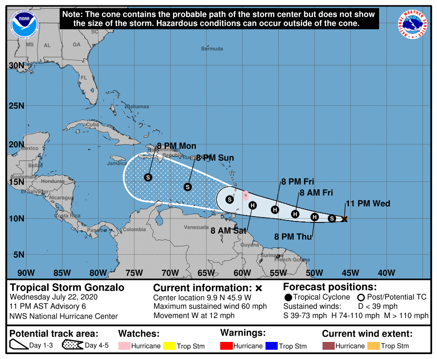
After a brief hiatus in Tropical Updates partly due to the lack of much to talk about, the tropics have suddenly lit up with activity heading into the last week of July. At 11 pm ET Wednesday evening, Tropical Depression 08L was newly designated in the Gulf of Mexico joining intensifying Tropical Storm Gonzalo well out in the tropical Atlantic east of the Lesser Antilles.
Twitter provides instant real-time updates of storm tracks, the wind speed, and any changes to the forecast cone or philosophy from the National Hurricane Center. If you periodically look at satellite imagery and check the model spaghetti or global models every 6-12 hours, then you should be reasonably informed by what’s going on in the tropics right now. There really aren’t any secret tools or information that the public cannot access. But, of course, being a tropical forecaster requires some specialized knowledge and experience that is picked up through practice. I have over 15-years of tropical forecasting experience beginning in earnest with the busy 2004 Atlantic hurricane season. So, I have intuition and a hunch (educated guess) about what Gonzalo’s fate but confidence is low.
Tropical Storm Gonzalo
NHC forecasts Gonzalo to become a hurricane within 24-hours but if you are a believer in the HWRF model guidance — and I am — then you will be even more bullish with maximum intensity to perhaps major intensity (100-knots). The NHC maximum is a 70-knots (Category 1) hurricane. HWRF 18Z initialized Gonzalo with 999 hPa central pressure and 40-knot winds but rapidly intensifies it to 964 hPa in 39-hours. The model has 1.5 km grid spacing of the inner-nest so it is the highest resolution operational model used by forecasters today for hurricanes joining the HMON. The small size of Gonzalo should favor a more intense storm since a nascent eye has been observed in microwave satellite imagery.

A hurricane watch has been issued for Barbados and if the storm intensifies more than forecast, there could be significant problems.

Tropical Depression 08L
A new depression in the Gulf of Mexico is expected to become Tropical Storm Hanna by Friday morning. The story of Hanna will be heavy rain with 2-4” currently forecast for the Texas coastline and well inland. The Gulf of Mexico will be cloud covered and rained upon for a period of time. The winds will be 35-45 knots so significant mixing of the ocean surface will generate waves and generally poor marine traffic weather. This could provide a slight brake on the Gulf of Mexico surface temperatures and mix up some cooler water.

What are the chances that TD 08L outperforms forecast guidance and becomes a hurricane? Very low. While forecasters are challenged by intensity changes in many cases, we are confident that Hanna will not explode into a hurricane (fingers crossed) due to its state of disorganization and wind shear.

Next week could get really interesting
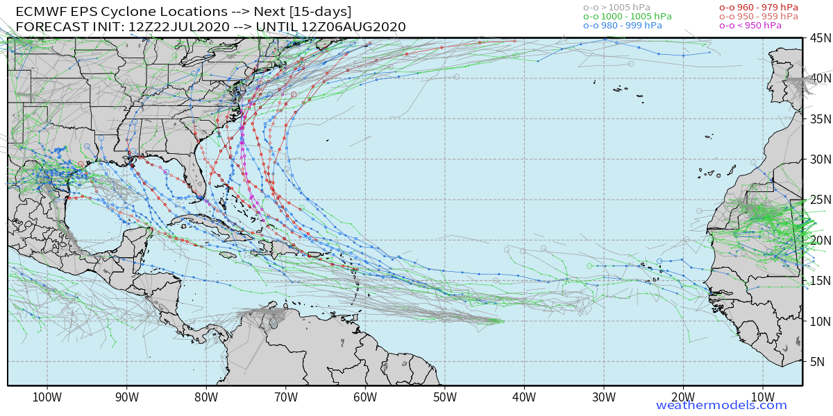
I am watching the ECMWF EPS ensemble spaghetti from my storm tracker over the next 15-days, and whoa, there are some ominous signals for a tropical wave developing into a long-track major hurricane with possible impacts to land.
Ensembles are just tools for potential scenarios — they are realizations that can provide probabilities of events. So, from the looks of the 51-ensembles combined on a map through 15-days, and seeing so many long-track hurricanes, this sends up alarm bells about favorable conditions for such development.
I’m concerned for the first week of August to have a powerful hurricane.
Too soon and irresponsible to predict any impacts other than to give chances e.g. 25% chance of another hurricane forming in the next 2-weeks that could become intense off the Florida or East Coast.
Keep watching the ECMWF ensembles over the next few days to see if these storm track signals persist. That’s about all we can do right now until there is a named system or significant tropical wave threatening development in the Main Development Region over very warm waters.
Maps from https://weathermodels.com (Subscription) — if you are a hobbyist or small business, then it’s worthwhile having access to all of the weather model maps especially if you are interested in longer range forecasts e.g. past 7-days.


Thanks for the email insight. I was wondering why I hadn’t heard from you about the “disturbance” but there you were tonight. Thanks for the info. Good job. Keep it coming.
Thanks Dr. Maue, I just signed up with Weathermodels.com today because you have the only site that I can find that plots the 15 day EPS spaghetti plots.