


July 12, 2024 Weekend Forecast
Extreme heat continues across much of the Lower 48 until next week

Friday Headlines
Extreme summertime heat [Lower 48 avg of 93°F] will spread across the Lower 48 for the next several days peaking next Tuesday, before some relief from a Canadian cold front / trough middle of next week.
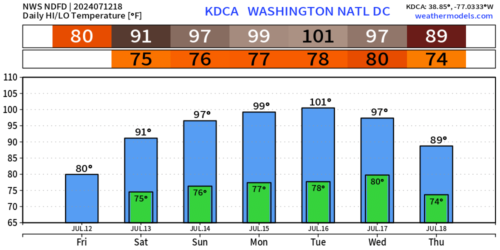
101°F in Washington D.C. on Tuesday.

Monstrous ridge (500 hPa heights > 630 dm) over the Western Atlantic off the East Coast breaks down briefly before moving back into position by next weekend. The persistence of a strong Bermuda High would definitely block any tropical systems from affecting the East Coast.

Integrated Vapor Transport (my favorite weather parameter along with precipitable water) shows well the combination of the tropical disturbance blocked by the over-ocean heat-dome or mega-ridge w/clockwise circulation. Very cool.
Tropics are dead.
HRRR 48-hour Forecast from 8 AM Friday until 8 AM Sunday

Clockwise flow over Great Basin bringing some moisture and storms to the West
Complex of thunderstorms could develop overnight Saturday into Sunday morning across the Great Lakes (wind threat)
Dry and very hot across the Southeast once the tropical disturbance exits offshore.
Meager rainfall amounts through late Sunday … lucky if you see anything away from the East Coast and upper-Midwest.

Blend of Models High Temperatures
Saturday July 13

Lower 48 Average: 92.5°F | 187 Million at/above 90°F | 28.4 M at/above 100°F
Sunday July 14

Lower 48 Average: 92.7°F | 256 Million at/above 90°F | 26.0 M at/above 100°F
Interesting very high heights over the Equator
Trying to understand what this means … but nothing tropical cyclone related is developing under this ridging in the tropics.

Ensemble Tropical Storm Tracks Next 15-days
Keep reading with a 7-day free trial
Subscribe to Weather Trader to keep reading this post and get 7 days of free access to the full post archives.