


July 10, 2025 Hurricane Season Thursday
Atlantic and Eastern Pacific have gone dormant and may be for 2 weeks

2025 Atlantic Hurricane Season [Day 40]. My expectation for this year is 14 named storms, 7 hurricanes, and 3 majors. So far, 3 named storm, 0 hurricanes, and 0 majors.
Thursday’s Tropical Update
Atlantic Basin: Nothing brewing for next 7-days, or 2-weeks from Ensembles
Eastern Pacific Basin: The basin has also gone completely dormant with ensembles blank through 2-weeks.
Western Pacific Basin: A new tropical storm is expected to form in the next 24-hours and track toward Japan as a Typhoon.
Current Satellite Imagery | United States
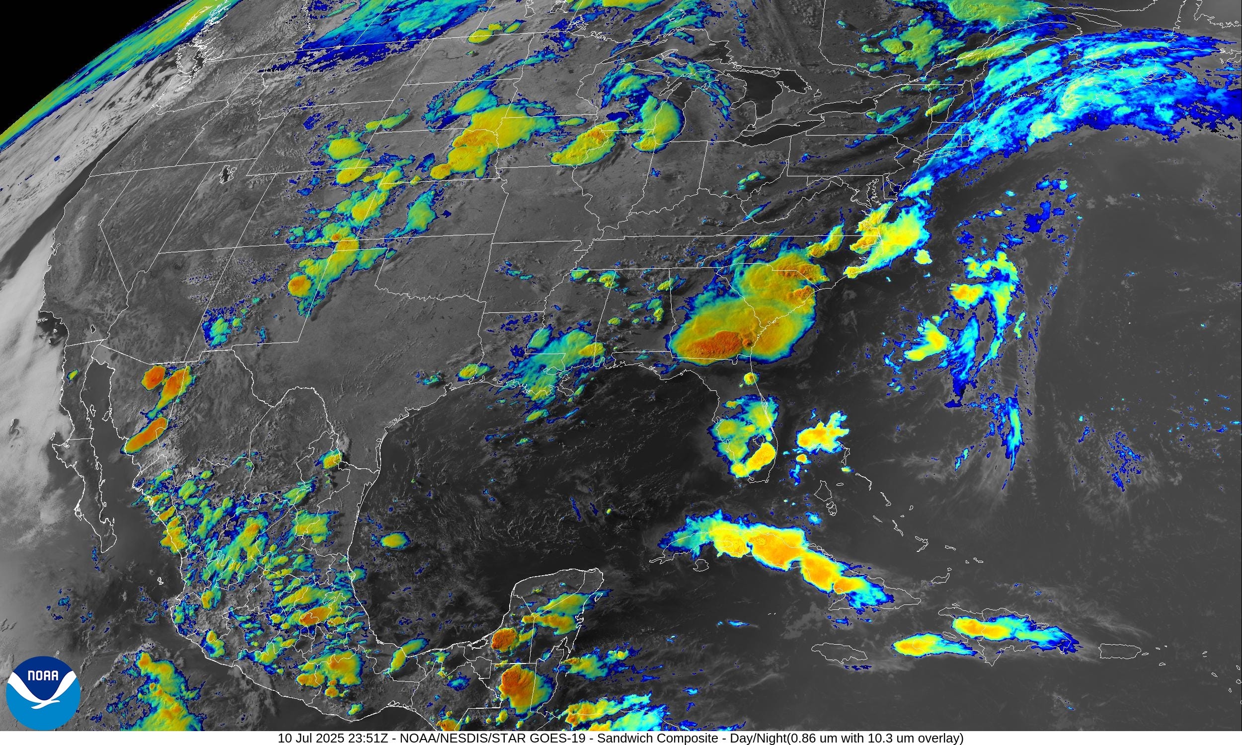
Heavy rain and showers moving through Southern Georgia and into North Florida in the coming hours.

Temperatures | 7:15 PM ET
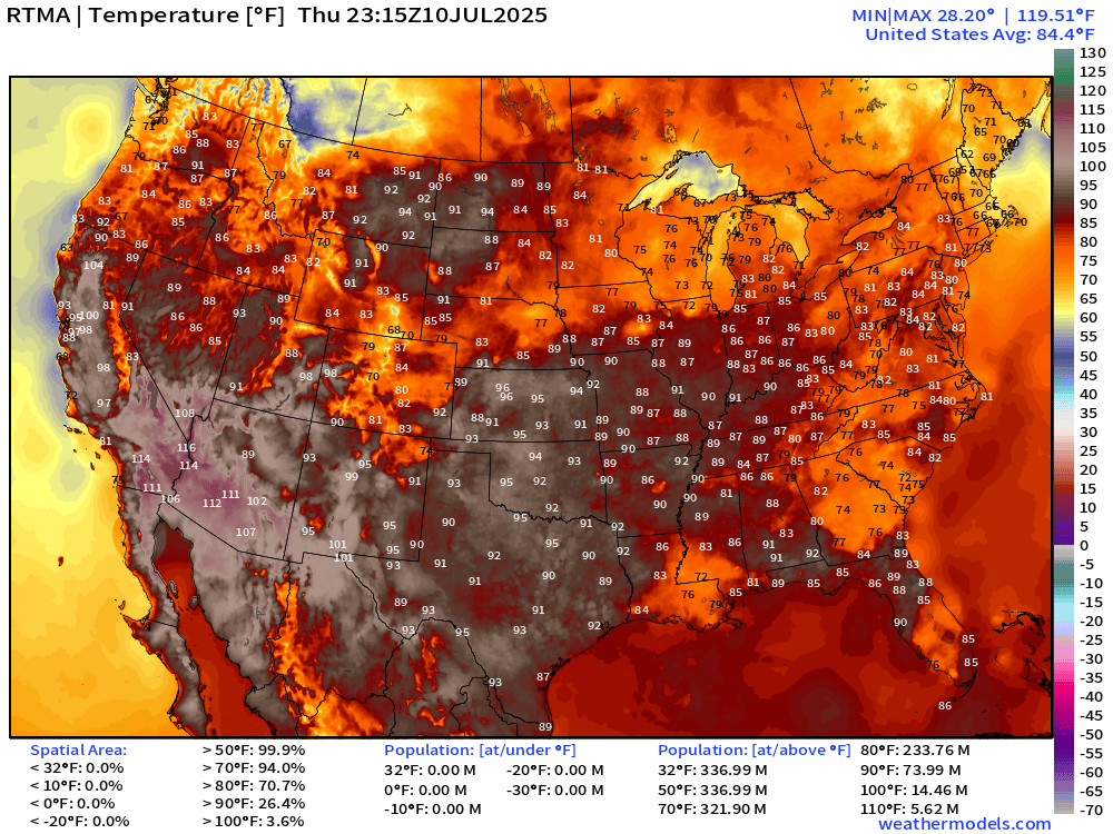
Rain earlier in the afternoon cooled off Atlanta and much of Georgia into the 70s. Same story for New Orleans. The July pop-up showers and storms provided free air conditioning.
Temperature Anomaly | 7:15 PM ET

Overall, the Lower 48 is 1.0°F above average with an interesting cool shot along the Canadian border in Montana.
Lows Friday morning

Chilly in the northern Rockies. 60s and 70s across the central and eastern U.S. while Phoenix may not dip out of the 90s.
Highs for Friday

HOT for 160 million at/above 90°F and 21M at least 100°F. Almost 95% of the United States population is at least 80°F for high temperatures = summer in America.
HRRR Radar Simulation Next 18-hours | through 12 PM Friday

Weather into Friday morning

Heavy rain and potentially severe storms in the central Plains centered on Iowa.
NWS Precipitation Next 48-hours

Weather on Friday

NWS WPC Precipitation Next 7-days

HUGE rainfall totals across Florida, and the moisture feed out of the Gulf of Mexico dumps at least 2-inches in the central U.S.
ECMWF 12Z | Integrated Vapor Transport | Next 8-days
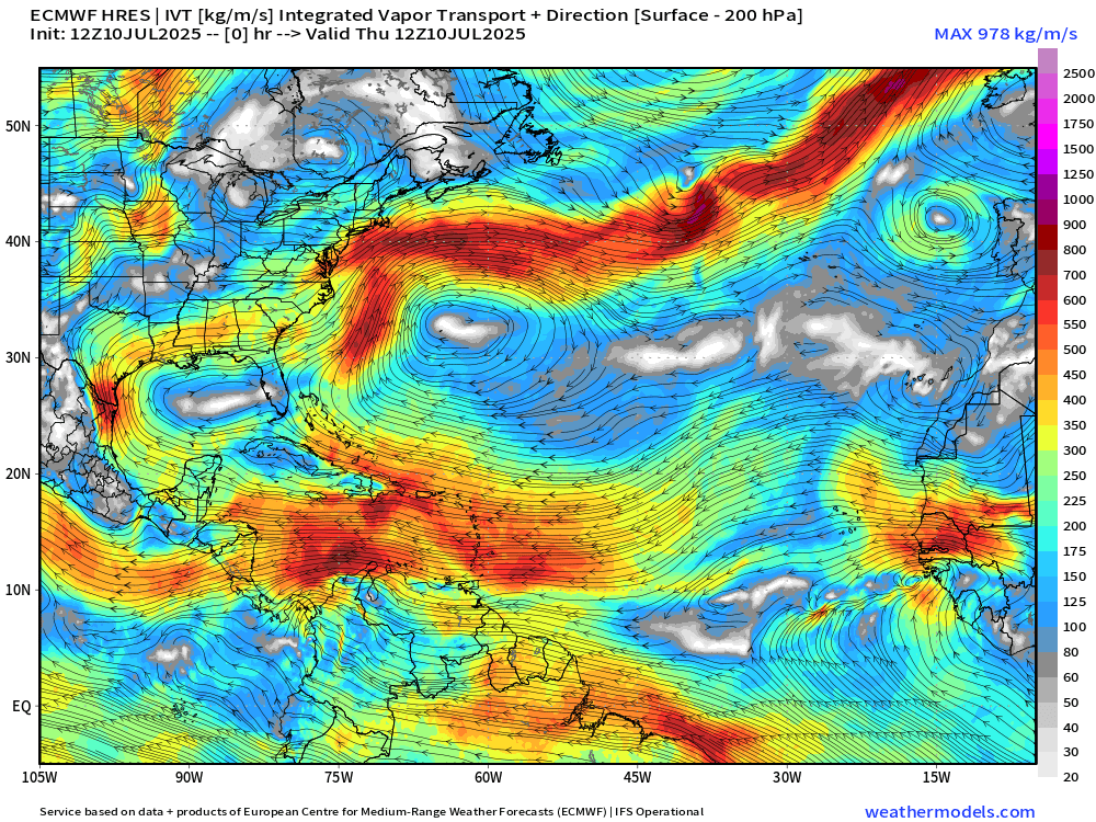
I like watching the evolution of the subtropical highs from Bermuda to the Azores.
Tropical waves do come off Africa and they have a broad, large scale circulation. However, they can’t get kick-started into self-sustaining tropical convection.
Weekly Temperature Anomaly | ECMWF 12z Ensembles


Note the blue and green on the weekly maps — as an Arctic blast infiltrates the upper-Midwest and Northern Rockies. Yes, cold and some snow in mid-July. This is not the signal you’d expect for a “heat dome” or climate fueled summer.
Thank you to readers continuing into this Hurricane Season. My goal is to keep you informed about ongoing extreme weather events inside and outside of the tropics, but also a week (hopefully) heads up on what’s coming. I’ll be using a variety of weather modeling output, some of it may be unfamiliar, but it’s state-of-the-art and industry leading standard.
Keep reading with a 7-day free trial
Subscribe to Weather Trader to keep reading this post and get 7 days of free access to the full post archives.