


January 8, 2025 Wednesday Winter Weather
Winter Storm will create a mess across North Texas into the Southeast

Good Wednesday evening.
A lot going on across the Southern tier of states from catastrophic Santa Ana wind fueled wildfires in Southern California, to a developing and potentially crippling winter storm from Texas to North Carolina.
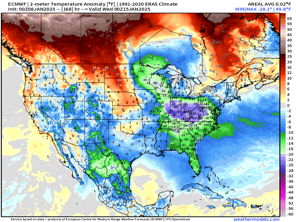
Colder than normal temperatures look solidly locked past mid-January.
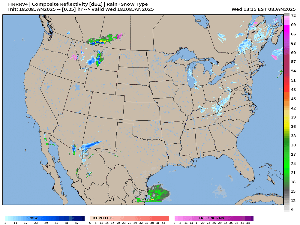
I’ll start with the 48-hour HRRR simulated radar from 18z as it’s the best way to visualize the complete mess over the next 2 days.
This system is directly a result of the upper-level low that I’ve mentioned over the past 7-10 days — which wasn’t in the A.I. models or ensemble means, and seemingly developed instead of the extreme Polar Vortex Arctic blast that was in the solutions.
A surface low develops along the Gulf Coast and scoots eastward rather rapidly. This storm event will feature rapidly transitioning precipitation types mainly because of temperatures aloft as near-surface temperatures will remain precariously close to freezing where ice/freezing rain/snow will mix.
I’ll post NWS maps for the outcomes since they are official and then suggest what may happen to their prognostications based upon new/updated weather model data. Eventually, everyone will reach the final destination of the most accurate forecast to communicate to the public.
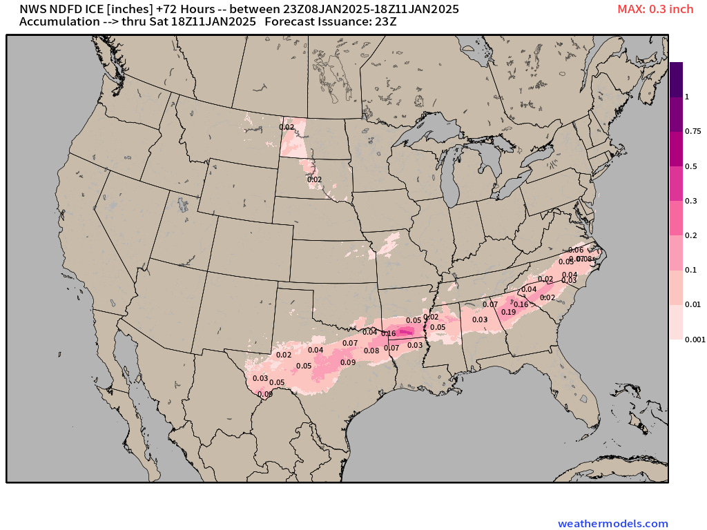
Ice Accumulation
Widespread light amounts except up to 0.1” around Dallas and 0.2” in Atlanta metro. Obviously not good for travel or trees/power lines.
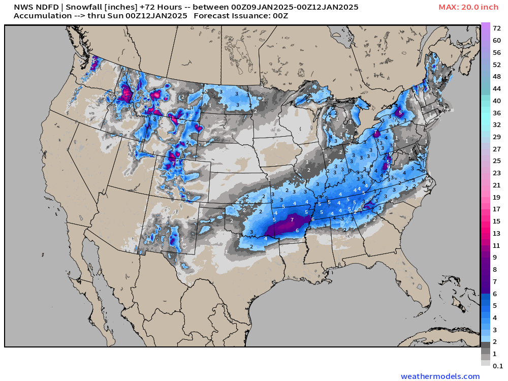
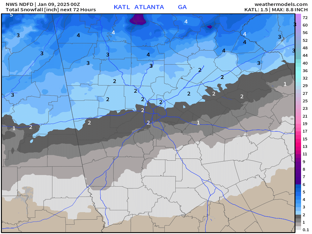
NWS Snowfall Next 3-days
Quite a healthy swath of snowfall from North Texas (2”-4”) through Arkansas (up to 9”) and then 2” around Atlanta with 3”-6” from Nashville into Ohio. Quite the coverage!
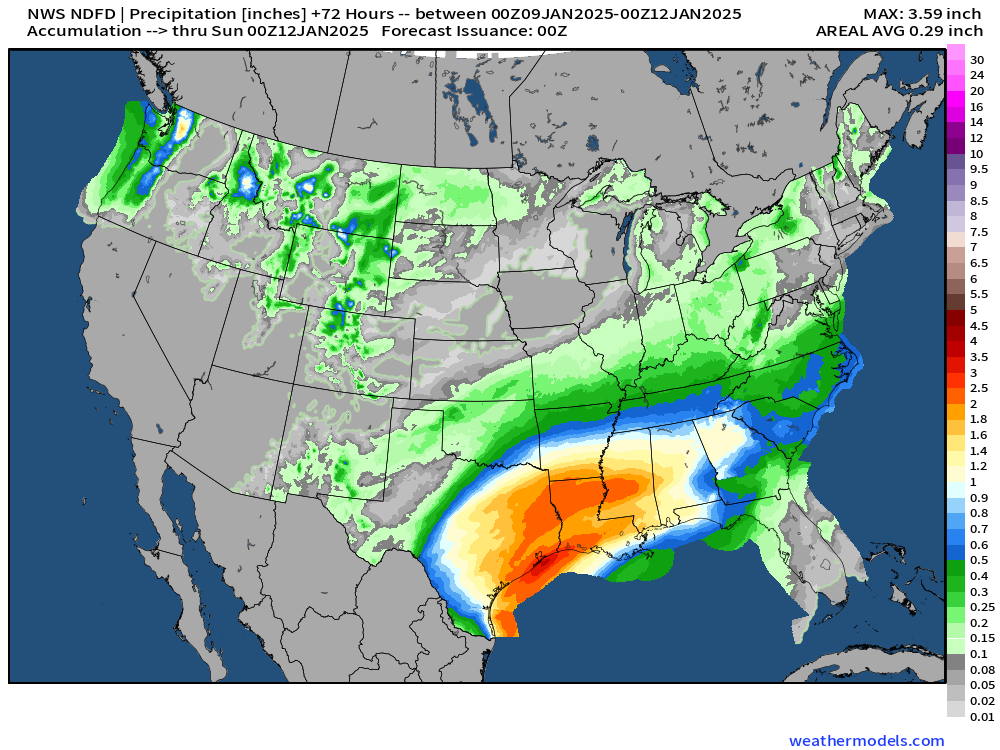
NWS QPF Next 3-days
Heavy QPF in the 2-inch or more range along the Texas Gulf Coast and up to 1” or so into Alabama and Georgia. Thankfully this is NOT all falling as snow or we wouldn’t be able to find our cars.
North Texas Winter Weather Threat | Thursday
HRRR “mixed” bag of precipitation Thursday around Noon local.

My meteograms help out to show the precipitation type changes and the 2-meter temperatures e.g. Dallas Fort Worth. I’d like to get everyone access to these types of charts soon. HRRR has 5” of snow snow and then some sleet, but really no p-type as rain. So, 0.9” of QPF needs to dump out, and HRRR thinks mostly heavy, wet snow.

NWS Snowfall Around Dallas Fort Worth Metroplex
2.3” at KDFW with gradient from 1” to 4” across North Texas


Crazy to see Little Rock loading up with 9” of snowfall.

Comparison with the ECMWF 18z HRES model
Much more snowfall around Dallas and North Texas — significantly so compared to NWS.

The precipitation type is almost all snow with 1.0” of QPF with temperatures in the low-30s.

Not sure how/why to dismiss this very consistent forecast, but even if we see less snowfall, that QPF still needs to fall and it’s probably going to be sleet or freezing rain, which isn’t an improvement. I guess we’ll know by the 00z update what’s going on for sure.
Storm Moves East into the Southeast on Friday
This is shaping up to be a complete mess with snow and sleet and freezing rain shifting to all rain eventually on Friday.
Friday morning 9:00 AM | HRRR
Mixed frozen precipitation into Macon, Georgia is quite rare. Heavy thump of snow for all of Atlanta metro.
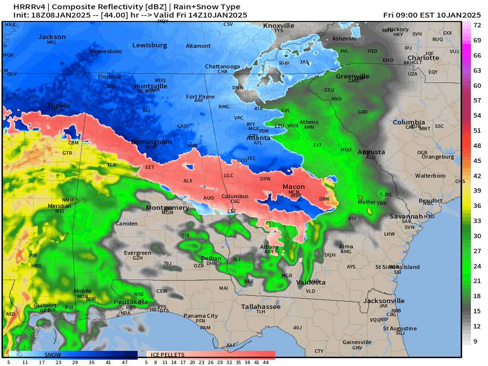
NWS has 1.5” at the airport increasing to 2-3” northward into the mountains.
ECMWF 18z has about 3” of snowfall but with with the mixture, I’m fine with less as a forecast. Later into Friday afternoon, a very cold rain will fall — and perhaps freeze later overnight as temperature remain around freezing. Huge black ice threat.

ECMWF 00z Insanely Cold Forecast
This was an all-timer forecast run again from ECMWF HRES, which historic cold. Fortunately, it moderated for 12z, but that piqued my curiosity about why the unperturbed or control member of the ensemble so often as the most extreme outcomes. The odds are 1 out of 51 that this can happen, but it seems to more often than that! Not sure what’s going on.
Denver had -26°F on Jan 21 for a low from HRES.

And, from the ensemble minimum matrix, that was by far the coldest option. There are other very cold members, too, but not that extreme. Just something to watch and think about into third week of January.

7:15 PM ET Temperatures across the Lower 48

Lower 48 temperatures are cold with average of about 29.4°F. 188 million freezing, but only 30K subzero, so it could be a lot worse.
Temperature Anomaly | 7:15 PM ET

Overall the Lower 48 is -6.2°F (below normal) with broad swatch of green (at least 15°F below normal)
Thursday Low Temperatures

Subzero temperatures almost entirely gone from the Lower 48. Yay!
89% of the Lower 48 is freezing, and 244 million population. Lower 48 average is 19.4°F
Thursday High Temperatures

Still 116 million below freezing for daytime highs. Lower 48 average is 35.3°F
Friday Low Temperatures

233 million at/below freezing, and 86% of the area of Lower 48.
NWS WPC 7-Day Precipitation | QPF

1.1” falling in DFW … up to 3” along Texas Gulf Coast during the next 3-days
6-Days Ensemble Snowfall 50th Percentile Solution
9” is the ensemble median in Dallas Fort Worth, and 10-12” into Little Rock. This assumes 10:1 ratios, so we should slash them by 1/4 to 1/3 so 6” is fair.


Extend to 15-days

Best practice is to always to use Ensembles, sorted according to an event threshold for probability mapping!
Probability in the next 15-days of at least 6-inches of snowfall

ECMWF EPS 12z | 5-Day Chunk Temperature Anomaly
Days 1-5: January 8 - January 12

Days 6-10: January 13 - January 17

Days 11-15: January 18 - January 22

Cold in the Western U.S. — and that’s got to come east for the last days of January. Boo.
For new followers coming from Substack, X, or friends, you’ll get daily updates of mainly Lower 48 weather including winter storms, heat waves, hurricanes, and now Arctic blast. The goal is to provide a “heads up” to impending extreme weather in the coming 1-2 weeks — medium range weather prediction. I use the best and most advanced Numerical Weather Prediction (NWP) systems including ECMWF ensembles, NOAA GFS, and the state-of-the-art A.I. systems.
Who writes and researchers this Newsletter? Dr. Ryan N. Maue [X https://x.com/ryanmaue] with 20-years experience of daily weather model production and analysis. You may have seen my weather maps! I live in Atlanta but was born and raised in Northern Michigan. I know snow, and southern heat and humidity.
Maps sourced from weathermodels.com designed and innovated by yours truly! Please subscribe there for real-time access to the newest maps, charts from all of the weather models including ECMWF.