


January 6, 2024 Saturday Update
Blockbuster Blizzard and Polar Vortex Watch
Quick update to bullet point what I am watching today — which has been very busy with some unbelievable weather model output.
I get some pushback from meteorologists on X when I “hype” storms or extreme weather, but if I’m ignoring something, then it probably means it’s not important or going to happen. So, that means if I’m concerned and using up my time and bandwidth to sound the alarm, then it’s probably a good idea to pay attention. A good example was the record heat wave in Portland in the summer of 2021. The models showed the blazing hot signal 9-10 days in advance. And, it turned out being even more severe and hotter than initially expected.
Polar Vortex / Arctic Blasts + Blizzards

We can’t speak about the extreme cold without digging into the details of the upper-level troughs (associated with lobes of the tropospheric polar vortex) and a series of powerful storms — at least two blockbuster blizzards in the center of the U.S. that almost overlap but 4-days apart. Sorry St. Louis if these come to fruition.
Blizzard #1 is on the way — Monday and Tuesday
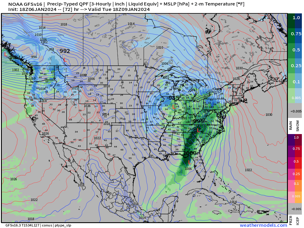
Blizzard #2 is next weekend w/extreme wind threat to coastal New England with Hurricane force wind gusts with Low Level Jet.


The 8-day GFS snowfall totals are amazing — doubling up from each blizzard on the backside of the Low Pressure systems.

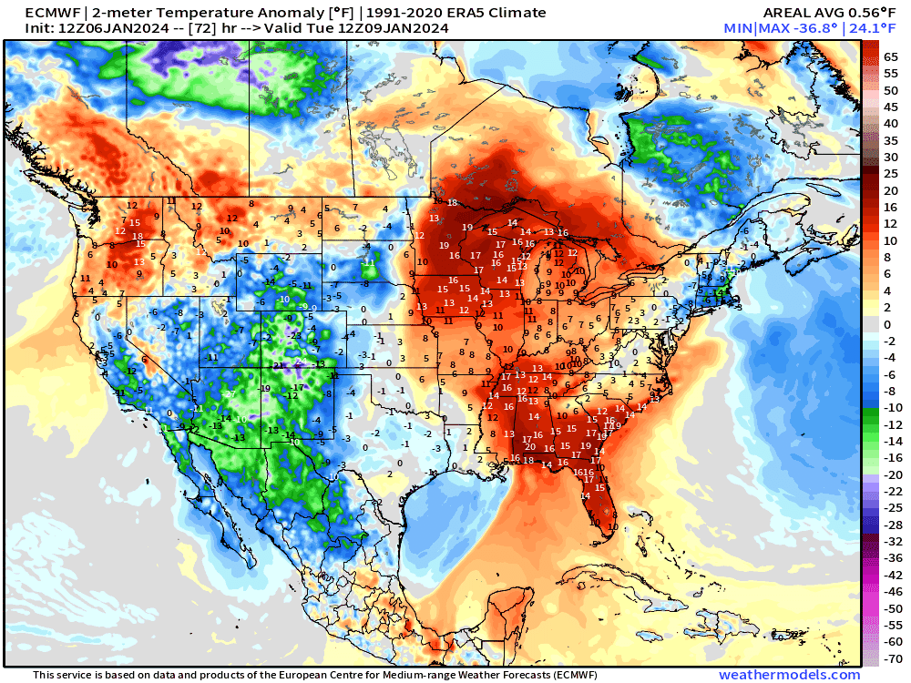
And with all of this snowfall, the ability of the cold air to extend eastward will be much easier. This was the ECMWF 12z forecast showing the extreme cold pooling in the Pacific NW and eventually leaking down the lee of the Rockies into Texas and the central U.S.
This is a very concerning situation! All we can do is watch and wait for the event to get closer to nail down the details — but each successive model is trending slightly eastward sparing California and the Southwest — but slower progress into the Plains.
Temperature Outlook Next 2 Weeks
These are 7-day averaged ensemble mean chunks so heavily smoothed. Nevertheless, the overall signal for extreme cold is very high extending along the lee of the Rockies into the central U.S.
Uncertainty in the actual 14-day trajectory is also significant, but if you pick almost any ensemble, there is some region that gets severely cold temperatures whether it is the Pacific Northwest or South Florida.
Week 1: January 6 - January 13, 2024 [EPS Mean 12z]

Week 2: January 13 - January 20, 2024 [EPS Mean 12z]

The EPS control 12z — out at Day 13 — freezes the entire Florida peninsula. Of course, this is NOT the official forecast, but a scenario that needs to be watched closely over the next week to determine if the Arctic blast trends in the direction of increased severity over Florida. This is akin to watching the development and track of a Category 5 hurricane way out in the Atlantic.

7 Day Precipitation Outlook
NOAA WPC 7-day Total Precipitation including rain and snow together.
Excessive rain across the eastern U.S. including up into the Northeast.

4-5” of RAINFALL around New York City from the consecutive storms — very serious situation!

Up to 67 Trillion gallons now for the next 7-days across the Lower 48!
Snowfall Next 2 Weeks
The EPS 15-day median snowfall totals across the Lower 48 are astounding. Also, a high potential for extreme accumulations in the Cascades and Sierra.
The Great Lakes will finally get buried, and more for New England. Welcome to winter!

All maps are probably from weathermodels.com (please subscribe there for affordable, professional, and beautiful weather maps created by yours truly).
Thank you to my paying and freemium subscribers!
Your support pays for my Linux servers and product development. Also, it allows me to provide (usually) interesting and valuable commentary on scientific topics on X. Feel free to say hello and follow on X/Twitter (@RyanMaue)
Old News:
This newsletter will rebrand in 2024 as part of roll out of [WT] https://weathertrader.com