ECMWF HRES 12z was alarming to say the least with historical and monumental extreme cold from an Arctic blast over Western U.S.
Temperatures are up to -77°F below normal — a hilarious number, but that puts actual temperatures in the minus 50s in some locales. And, while this is a 10-day forecast with an extreme outcome, the ensembles support the “Polar Vortex” blast into the Lower 48 in the 8-12 day time frame.
This pendulum or wrecking ball is on par with the January 2014 O.G. Polar Vortex.
In this case, there is a combination of multiple smaller scale troughs or potential vorticity anomalies that combine into an extremely intense one.
This setup would mean single digit temperatures in Seattle and Portland with heavy snow to the Pacific Ocean at sea-level. Here is the 10-day snowfall map from ECMWF 12z.
In this weather pattern — in today’s warming climate +ongoing El Nino — it’s unthinkable that we have this extreme winter solution on the table.
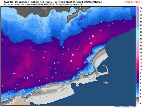
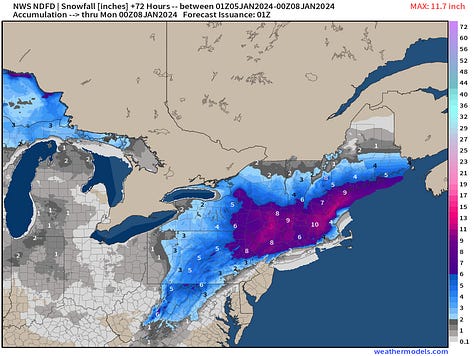
NWS has issued its snowfall grids for the Nor’easter. It’s about what we expected with the main uncertainty in the “accumulation” in Boston at Logan vs. “snowfall” that comes out of the sky.
Boston 4” at Logan and NYC Central Park at 2”. But go inland 10-miles and you might see a foot of very wet snow.


The best model output takes into account the Snow Liquid Ratio (SLR) with near-surface temperatures correction to the typical 10:1 SLR applied to QPF.
So, here we have Boston at 6” from ECMWF 18z, but NYC at 7”. So, there’s some fine tuning still required tomorrow.
Keep reading with a 7-day free trial
Subscribe to Weather Trader to keep reading this post and get 7 days of free access to the full post archives.


