January 4, 2024 East Coast Storm
First winter storm in a long time for the Northeast then the Polar Vortex
It’s been a while since cities along the I-95 corridor experienced any snowfall with an ongoing snow drought in D.C. and Philadelphia extending back into 2022. However, the forecast for Washington and NYC is not too bullish for snow, but instead a mixture and heavy rainfall. Indeed, heading into next week, the prospect for very heavy rain with localized flooding will be considerably more impactful.
In Boston, the situation is more uncertain with recent ECMWF HRES cycles alternating between mixture and snowfall. The most recent forecast cycle from 06z leans heavily into the snowfall category with 12” [10:1 SLR] at the Logan grid point. The precipitation type is declared wet snow or snow in the model, so while there may be 1-inch of QPF to fall, the conversion to snow may be 6” to 8”. It’s up to you whether you want to shovel heavy wet snow with temperatures in the 30s or lighter, fluffier snow in the upper-20s.
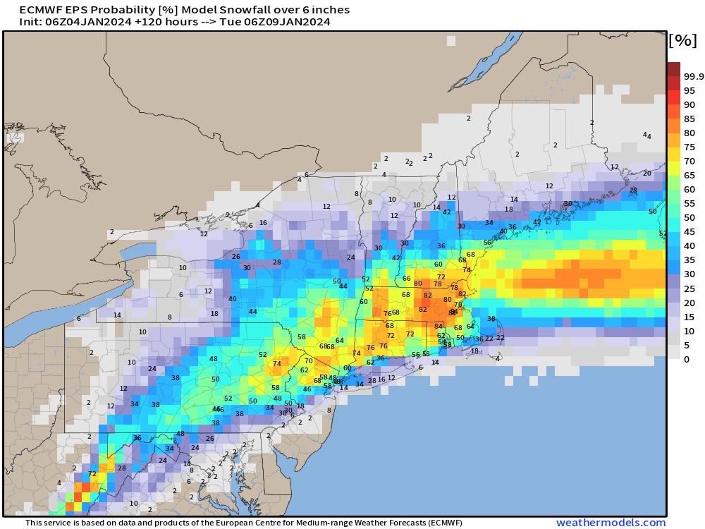
Another way to look at the uncertainty is through percentile and probability maps e.g. what’s the median expected snowfall OR the probability of exceeding a threshold like 6”. This is calculated from the most recent ECMWF EPS ensembles with 51-members so every solution is worth 2%.
The median snowfall amount is 7”-10” across New England including Boston. However, the heavier/wetter SLR (snow liquid ratio) will mean less actual accumulation especially with melting. Interestingly, NYC is sitting at 6”. I’m not expecting much in the way of snowfall in the Big Apple but there could be an interesting mixture of rain/snow/sleet that accumulates into a messy slush.
The highest probability for 6” of snow or more is in Massachusetts. With the lower ratios, this could be better thought of as 4”-6”. Still another day to fine tune the details, so a slight adjustment of the storm track to the east would significantly dial up these numbers with colder air available for all-snow solutions.
Excessive Rainfall Into Next Week
The NOAA WPC 7-day precipitation forecast (includes rain and the liquid equivalent of snow/mix) is very concerning for the Southeast up the East Coast into next week with a large area of 2-4” of rainfall, and locally much more along the Florida panhandle and at higher elevation in the Carolinas. This is associated with the next big storm system.
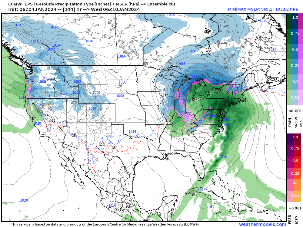
Next Powerful Storm System Monday-Tuesday
This storm will have a central pressure in the 960s — that is very deep over land in winter. That means elevated risk for severe weather in the South ahead of a potent cold front. As the system tracks through the Great Lakes into Canada, that frontal boundary will be the focus of an intense low-level jet along the East Coast — again a high-wind threat!
While the current focus is on the weekend storm event, the following storm system will be much more intense and impactful.
Arctic Blast
Behind the powerful storm system will be an Arctic blast courtesy of a lobe of the Tropospheric Polar Vortex.
This is extreme cold even for mid-January — on the 10-year anniversary of the infamous “polar vortex” disaster of January 6, 2014. While the details are uncertain about where will see the most intense cold, the path is different than in 2014. Instead, the trough will dig into the Western U.S. and then Texas. The following two maps are from the ECMWF HRES 00z version that extends to 10-days.
Notable: the enormous ridge over Greenland with heights of > 573 dm at 500 hPa. Wow.
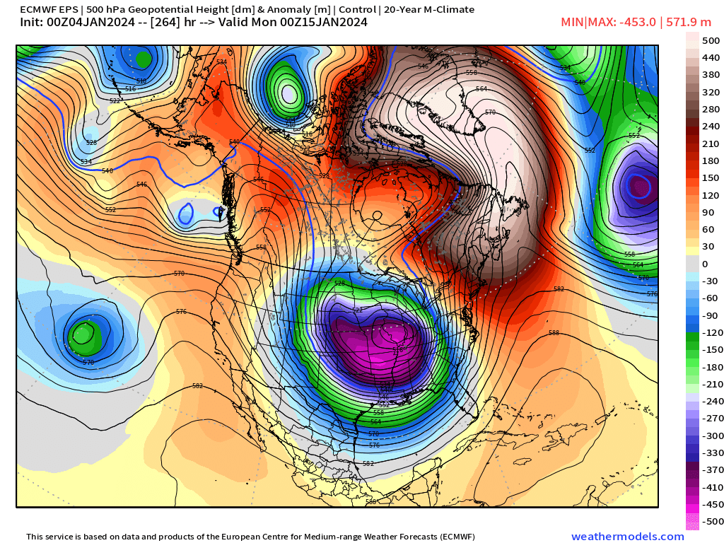
With the most recent update of the ECMWF model suite, the ensembles are at the same resolution and configuration as the HRES — 9 km and 137 vertical levels. So, we can look at the Control to extend our gaze past 10-days to game plan what will happen with the Arctic blast into mid-January.
Here is Day 11 — omg!
This would be an absolute wrecking ball of a polar vortex on top of the central Lower 48. However, before panicking, this is only “one solution” out of the possible ensemble suite, right?
Yes, but it has friends — and support for big negative numbers in Chicago by Jan 13th. That’s only 9-days away.
How to approach this type of forecast uncertainty in the 7-10 day time frame? Watch the ensemble trends — do we pick up more supporters?
Look to the A.I. modeling to assist in picking the right ensemble cluster. More on that tomorrow or Saturday.
All maps are probably from weathermodels.com (please subscribe there for affordable, professional, and beautiful weather maps created by yours truly).
Thank you to my paying and freemium subscribers!
Your support pays for my Linux servers and product development. Also, it allows me to provide (usually) interesting and valuable commentary on scientific topics on X. Feel free to say hello and follow on X/Twitter (@RyanMaue)


