


January 22, 2024 Much Warmer Week
Warming trend on the way
Weather Trader | Monday Update
Tropical Cyclone [90P] likely landfall threat to Queensland, Australia on Thursday
So far, Invest 90P [would be named Kirrily] has been struggling to organize in the Coral Sea but is drifting SW toward the Australia Queensland coastline. Models including ECMWF and BOM ACCESS-G and mesoscale HAFS show a likely major hurricane strength cyclone [960s mb pressure] landfall on Thursday. Pinpointing the location and intensity of landfall is uncertain until the center forms.

The result will be torrential landfall as with most Tropical Cyclones that meander over Australia. They have a way of self-sustaining over the parched landscape creating a wet layer on the surface/sand/rocks that is called the “Brown Ocean Effect”.

Mesoscale Hurricane Models HAFS is NOAA’s newest creation that is truly remarkable in its ability to reproduce and project the track and intensity of the most intense global tropical cyclones. It’s a relatively new model so experience is limited, but the HAFS solution for 06z is similar to the global models like ECMWF and BOM.

Monday Afternoon Highs
Finally get to stop yammering on about the Arctic blasts. The extreme cold will moderate every day under the impacts of heavy rainfall in the Eastern U.S. from a strong feed out of the Gulf of Mexico combined with the subtropical jet moisture conveyor belt off the Pacific.

January Thaw — Warming Trend
I’d like to mention that Edmonton, Alberta was in the minus 50s °F a little more than a week ago, and will be in the positive 50s °F by next Tuesday.
Tuesday Morning Lows | January 23, 2024

Still about 57% of the Lower 48 freezing by Tuesday morning, but mainly in the 20s and lower 30s across the entire country for coldest lows. There’s a big difference in 38°F in Atlanta vs. 18°F in terms of heating demands.
Tuesday Highs | January 23, 2024
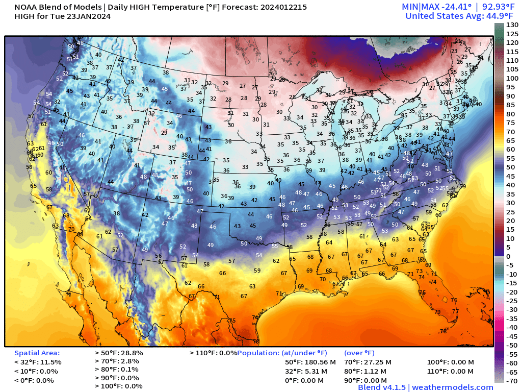
Only 5 million will remain below freezing on Tuesday. Melting the roofs and roads will create a mess especially in the Great Lakes where so much snow has fallen, but a welcome late January thaw.
Next 15-days Temperature Anomaly
5-day Chunks from January 22 to February 6, 2024
Alaska and Greenland will be brutally cold with much, much below normal temperatures. Conversely, the warmth relative to normal will be centered over Canada heading into February.
Keep reading with a 7-day free trial
Subscribe to Weather Trader to keep reading this post and get 7 days of free access to the full post archives.