


January 2, 2025 Thursday Winter Weather
Winter storm with major ice and snow impacts from Kansas to Washington D.C.

Good morning, Thursday January 2, 2025
Pattern change has finally plunged the Eastern U.S. into more winter season cold with long-duration below normal temperatures into mid-January.
Over the next 9-days until Friday Jan 9, we see daily average temperature anomaly generally in the 10°F to 15°F below normal range with colder (22°F below normal) over snow covered ground from the Winter Storm forming this weekend. The Western U.S. remains above normal, but 5°F to 10°F warmer than typical early January does not mean warmth at higher elevation. Still plenty cold for snowfall and the warmer Pacific origin air will have more moisture for heavier snow.

Winter Storm | Saturday - Monday
Using GFS 06z to show the evolution hour-by-hour of the low pressure center from Texas panhandle early Sunday to St. Louis early Monday, and then already off the mid-Atlantic coast by Tuesday as the Appalachians trigger transfer over ocean due to vortex tube stretching (conservation of potential vorticity).
North and east of the low center will be heavy freezing rain and sleet that could accumulate with temperatures in the upper-20s at the surface, but much warmer in the lowest levels of the boundary layer.
Warm moist Gulf of Mexico air in a low-level conveyor belt is lifted isentropically over the much colder Canadian air in place over the Plains, Great Lakes, and Northeast by this weekend.
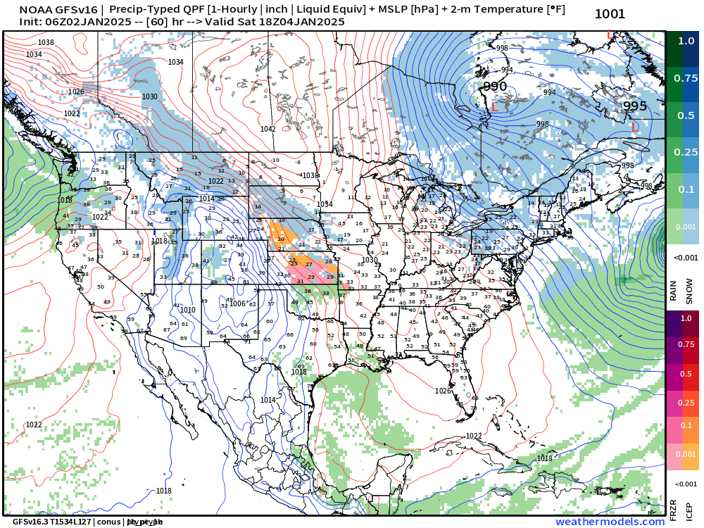
GFS 06z also is “very juicy” with much higher QPF numbers than ECMWF and the ensemble mean.
Using the precipitation type every hour for the next 5-days, I calculate the amount that will fall as snowfall. There is a narrow band of 1” to 2”+ QPF cutting through Southern Illinois with 0.5” to 0.8” including Indy, Cincy, D.C.

From that snowfall p-typed QPF, we can then use the near-surface layer to determine the ratio between liquid to snow (SLR) usually 10 or 12:1 in the 20s and lower-30s. Temperatures with this system in the heaviest snow bands will be in the mid-20s, so we can probably expect higher SLR and therefore higher accumulation numbers.
Maybe not as much as GFS 06z indicates, but I’d take the over on any ensemble or blended model output!

Same maps for the Plains


8:30 AM ET Temperatures across the Lower 48

Lower 48 temperatures are seasonable with average of about 28.5°F. 133 million freezing but only 200K below 0°F.
Temperature Anomaly | 8:30 AM ET

Overall the Lower 48 is still above normal +1.4°F (above normal) with warmest relative to normal in the Northeast and again across the Great Basin. The Southeast is cool. Montana and North Dakota seeing the coldest overall and relative temperatures.
Weather next 24-48 Hours

The little Clipper system moves through Iowa into the Ohio River Valley and into New Jersey by late Friday.
On top of ongoing Lake Effect Snowfall, could see another 1 or 2 inches of nuisance snow from Des Moines to just south of Chicago, into Indy, Cincy, and Philly.

NWS Precipitation Next 3-days


The winter storm is just outside the NWS forecast window of 72-hours.
Upper-Level Pattern Next 15-days | ECMWF AIFS 06z
Keep reading with a 7-day free trial
Subscribe to Weather Trader to keep reading this post and get 7 days of free access to the full post archives.