


January 2, 2024 Tuesday update
Winter underway by this weekend
So far, it looks like the A.I. modeling insists upon a colder and more snowy outcome for DC and NYC, but I am becoming less confident as the physics based NWP systems trend inland with snowfall.
The GraphCast-ECMWF [experimental/non-commercial] A.I. model still shows 2 systems in sequence tracking from the Southeast into New England with heavy precipitation.

Let’s zoom in on the Mid-Atlantic:

The 32°F line is right over Washington D.C. so that’s heavy QPF that should fall as snowfall.
[Again, this is the first real-time test of GraphCast’s winter precipitation and Nor’easter forecasting skill. I did not see any research or literature on how this A.I. trained model handles historical coastal storms of the non-tropical variety.]
Conventional physics based weather models are much warmer in D.C. and NYC with mostly rain (ECMWF). This is a tricky forecast. The good news is that the upper-limit of potential impacts is 6-9” of snowfall, most of which would be wet. The trend is for the snowfall to move inland away from DC and NYC. However, Boston looks cold enough on the backside of the system for a nice snowfall.

The inland trend looks like GFS 12z. Look at all that Western U.S. mountain snowfall in the next 5-days.

Wednesday Low Temperatures | January 3, 2024
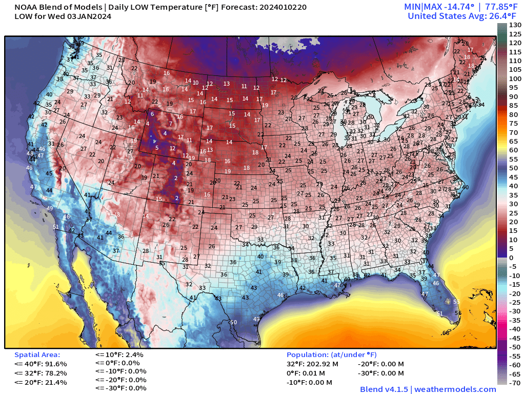
203 million Americans at/below freezing but still no “extreme cold” or subzero temperatures, which is indicative of the extreme warmth over the northern Lower 48 and Canada. However, that will change shortly.
Wednesday High Temperatures | January 3, 2024

Almost 10 million Americans at/above 70°F mostly in Florida. Again, the Lower 48 is overall warmer than normal with 30s in the Great Lakes and 40s in the Ohio Valley.
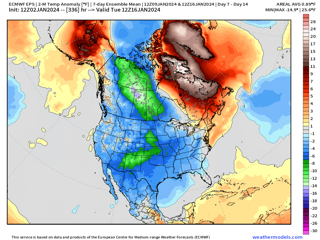
Temperature Outlook Next 2 Weeks
By next week, the Arctic express is on a direct course with the Lower 48. The question remains what is the intensity of the polar vortex intrusion into the Lower 48, and where it aligns with the Rockies.
Week 1: January 2 - January 9, 2024 [EPS Mean 12z]

Week 2: January 9 - January 16, 2024 [EPS Mean 12z]
7 Day Precipitation Outlook
NOAA WPC 7-day Total Precipitation including rain and snow together.
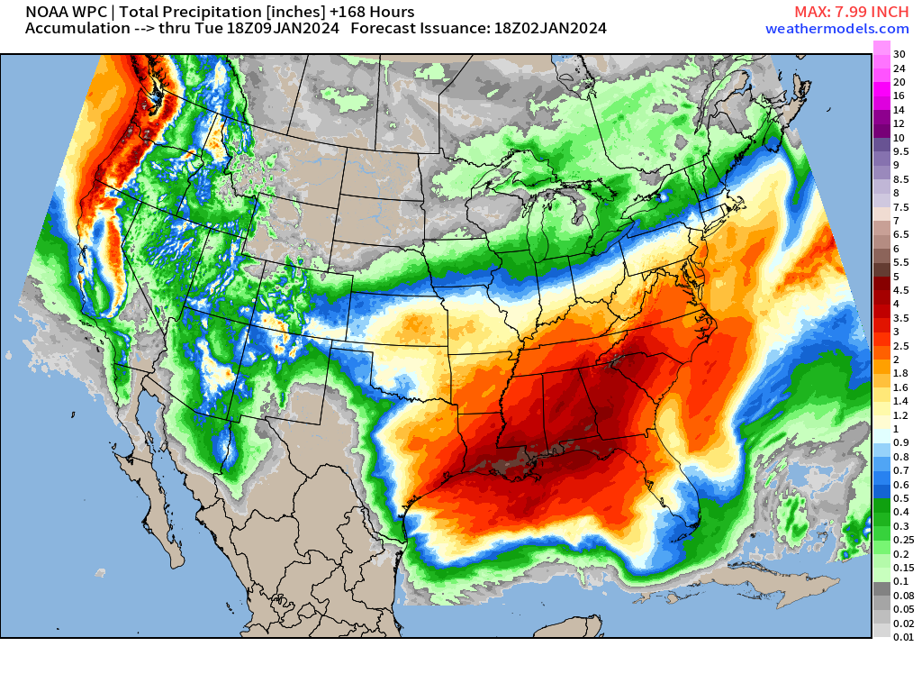
The Southern U.S. is in line to see widespread 2-4” of rainfall in the next 7-days as the subtropical jet scoops up Gulf of Mexico moisture for the developing Nor’easter, and then another that follows.
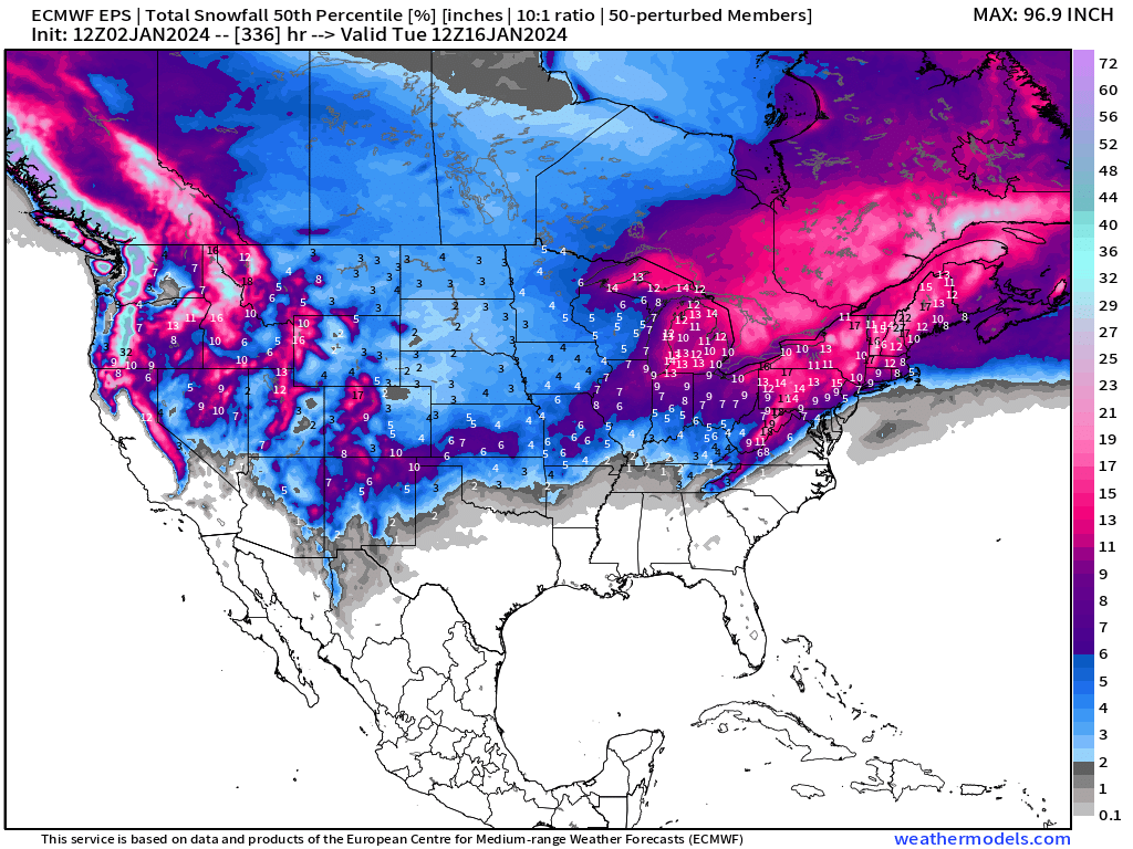
Snowfall Next 2 Weeks
Next 7-days EPS median (50th percentile) outcomes from the 12z ensembles show the winter storm across the Mid-Atlantic and Northeast with large coverage of at least 6-inches of snowfall this weekend.

Winter does not end! The pattern remains bullish for continued chances of significant snowfall from coast to coast into mid-January.
I’d like to note — look at the West Coast! Extremely cold air with intense trough and flow directly from the Canadian Arctic.
All maps are probably from weathermodels.com (please subscribe there for affordable, professional, and beautiful weather maps created by yours truly).
Thank you to my paying and freemium subscribers!
Your support pays for my Linux servers and product development. Also, it allows me to provide (usually) interesting and valuable commentary on scientific topics on X. Feel free to say hello and follow on X/Twitter (@RyanMaue)
Old News:
This newsletter will rebrand in 2024 as part of roll out of [WT] https://weathertrader.com
Is weathermodels.com a separate subscription than this substack subscription?