


January 15, 2025 Wednesday Evening Update
What's going on with Apple Weather?

Good Afternoon.
Please consider upgrading to a paid membership to receive all posts to email (or via the Substack App) as we head into a very eventful mid-January winter period. Your growing support allows me to dedicate more and more time to this platform, eventually hoping to be full time.
Headlines for Monday Evening
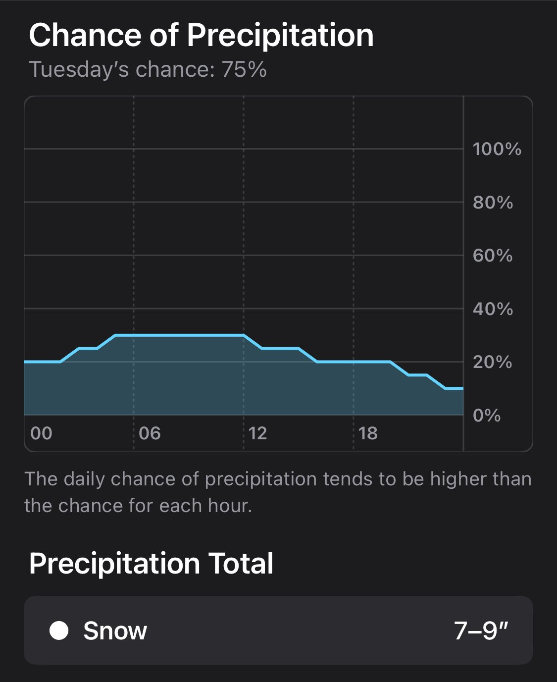
What’s up with Apple Weather? Folks on social media are posting screenshots of wild forecasts of snowfall in various cities in the South including Houston and Atlanta. I did some poking around at various locations to see if I could figure out what Apple did with Dark Sky — a weather data service attached to a popular App that Apple acquired — and turned into the WeatherKit API called Apple Weather.

Houston Snowfall Next Week on Tuesday Dark Sky was never the best option but had a cult following of dedicated users who were dazzled by the colors and interface and illusion of skill and accuracy with buzzwords like hyperlocal. However, the underlying forecast engine was really nothing more advanced than averaging of raw model grid output from the various global models like Canadian and GFS.
Prior to incorporating Dark Sky into their WeatherKit, Apple simply reused the Weather dot com API, which is based upon DiCast — same as AccuWeather. That is a MOS like post-processing engine developed many decades again akin to a super-ensemble. It is highly skillful.
Apple keeps its WeatherKit code opaque and proprietary — and I can only speculate why.
I would not recommend using Apple Weather. Use NWS or the other legacy apps.
Inauguration Day in Washington D.C.= cold. Temperatures in the 20s with wind chills in single digits.
NFL playoffs: Temperatures in the teens in Buffalo on Sunday. 30s in Philadelphia, but wind chills will make it feel much colder.
Severe Arctic blast to affect almost the entire Lower 48 starting this weekend. The peak of the cold will rival the nationwide temperature average from the “Polar Vortex” episode of January 2014. Some locations like Pittsburgh may see coldest January high temperatures since 1994.
At the margin of the cold air pool along the Gulf Coast from Texas to Florida, subtropical moisture could bring wintry precipitation, however there is considerable uncertainty: if the cold air pool and surface high pressure is too strong, the moisture will not be able to accomplish much = minor impacts. It will just be too cold and dry.
Warming trend into end of next week — horray!
Temperature Anomaly over the Next 15-days

While it looks like warmth over Canada will last a while and thaw out the Great Lakes and Northeast in a significant way, all of a sudden the bottom drops out and “Barney purple” buries the Lower 48.
Thankfully, this extreme cold is a Sunday to Thursday event from the Rockies into Texas and then east with a secondary extreme peak in the Ohio River Valley.
But, the following week, we see another “cold pool” develop in the northern Rockies and Pacific Northwest — a region that has largely escaped the worst winter cold so far. That could change in a huge way! Also, that would probably be VERY good news for precipitation along the West Coast including California with atmospheric rivers more capable of extending across the Pacific rather than gets shunted to Alaska.
Keep reading with a 7-day free trial
Subscribe to Weather Trader to keep reading this post and get 7 days of free access to the full post archives.