


January 15, 2024 Extreme Cold Continues
Winter weather from the Southeast into New England
This newsletter now has a more specific name: Weather Trader
Please consider upgrading to a Paid subscriber [$5/$50] to get the best/latest content going forward. The goal is to provide the same professional weather analysis and advice that is otherwise unaffordable to the general public. Access to the companion https://weathertrader.com will come with this subscription here (I’ll periodically export the paid subscriber list).
Arctic Blast entrenched across the Central U.S.
Wind chill temperatures still dipped into the minus 20s and minus 30s in the Plains and Great Lakes. Earlier in the 10 AM ET hour, the coldest readings in the minus 50s continued in Montana and the Dakotas.
Actual temperatures dipped to -10°F this morning in Chicago — a 2 for 1 because the temperature plummeted yesterday, too. No record lows, just luck of the draw. However, the record was only -9°F on January 13, so missed it by a day. Regardless, this is very cold for an extended period of time subzero, which might not go positive until sometime on Tuesday, maybe!

11°F in Dallas/Fort Worth (KDFW) with light snow apparently from the lakes north of the metro leaving a dusting on the ground this morning for Texans not too used to winter weather.

I showed a ton of “temperature anomaly” maps partly because I love my Barney purple color table. During the morning, the temperatures are actually less anomalous than in the afternoon so this map will brighten to light purple/pink later on Monday.
The overall CONUS/Lower 48 anomaly is -18.4°. There are 31 days in a month so a 18.4/31 contribution to the month’s climate anomaly.

Winter Storm tracks into Northeast through Tuesday
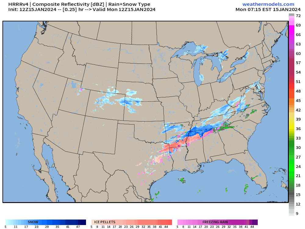
The 48-hour HRRR precipitation type model forecast shows a light to moderate band of snowfall moving into the Mid-Atlantic and Northeast through the day today into Tuesday. Meanwhile, another powerful system crashes ashore into the Pacific Northwest — with a serious freezing rain accumulation threat [> 0.25”] in Portland, Oregon.
Total Snowfall for the next 72-hours from NWS
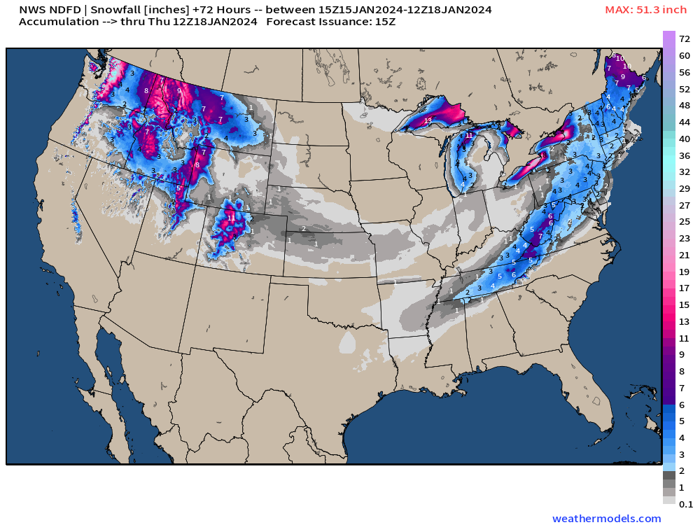
Northern Rockies snowfall is significant with this latest storm system. No compalints about lack of snowfall or cold up there in January!
The Great Lakes are wide open for business — that’s the Lake Effect snow machine that will build another foot or more along the Michigan lakeshores. Up to 30-inches on the Tug Hill Plateau and 18-24” in Buffalo!
NYC in the 1-3” territory, which is better than nothing!
Washington D.C. also 1” or 2” of snow. Maybe an inch in Boston.
Folks in Maine finally get significant accumulations of 6-10”.

Pittsburgh Steelers vs. Buffalo Bills [-10.0) 4:30 PM ET on Monday (O/U 38.5)

The game was postponed until this afternoon with conditions likely improving dramatically around 5 pm. Temperatures will only be 17°F but wind gusts slack off from 25 mph to 10 mph through the game. Any remaining snowfall should be much lighter than the burial going on this morning at Hallmark Stadium.
NDFD NWS Temperature Forecasts
Arctic Blast
Monday High Temperatures | January 15, 2024

Lower 48 average temperature high temperature is 23.4°F but huge disparity between -5°F in the Dakotas to 80s in South Florida ahead of the cold front.
Iowa Caucus this evening at 8 pm CT will see temperatures generally in the single digits below zero with lower wind chills, an improvement over the weekend.
Tuesday Low Temperatures | January 16, 2024

8.9°F Lower 48 average temperature. 87.5% of the Lower 48 is below freezing, and 243 million population. Again, Florida in the 60s from I-4 south.
Tuesday High Temperatures | January 16, 2024

Tomorrow’s highs moderate but remain below freezing as far south as Dallas/Fort-Worth. Sadly, Atlanta gets a taste of the Arctic air with temps in the mid-30s.
Meanwhile, California is in the 60s and 70s. Florida in the 70s and 80s. The Lower 48 has vastly different climates and a quick scan of the 7-day forecast can help you escape to a warmer destination whenever you want.
Temperature Outlook Next 2-Weeks
Warming trend!
Week 2 with much above normal temperatures [above freezing, too] centered upon Ontario. That’s good news as this will block the Arctic air and favor more of a westerly or zonal flow. That will help quiet the weather down overall.
Week 1: January 15 - January 22, 2024 [EPS Mean 00z]

Week 2: January 22 - January 29 2024 [EPS Mean 00z]

Snowfall Forecast 15-day EPS Median
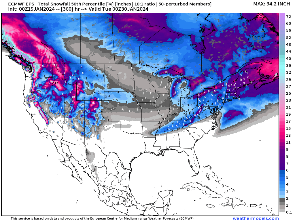
Most of this snowfall in the 15-day median forecast in the Great Lakes and Northeast is from the next few days. We may not see a major winter storm for at least a week or two, depending upon how strong this upcoming ridge becomes. More on that later.
All maps are probably from weathermodels.com (please subscribe there for affordable, professional, and beautiful weather maps created by yours truly).
Thank you to my paying and freemium subscribers!
Your support pays for my Linux servers and product development. Also, it allows me to provide (usually) interesting and valuable commentary on scientific topics on X. Feel free to say hello and follow on X/Twitter (@RyanMaue)
The southeast is weird to predict what will happen overnight..any quick analysis you can provide? I know the temps are dropping LOL