


January 11, 2024 Great Lakes Bomb Cyclone
Arctic blast slowly descends into the Lower 48
Powerful winter storm tracking from the Plains into Great Lakes on Friday should deepen pressure enough to be technically defined as a “bomb cyclone”. Over Michigan, the cyclone could fall to around 972-975 mb central pressure. That’s quite impressive for an over-land system.
The winds and snowfall will be plenty for blizzard criteria on the back side of the low. The gusty winds will spread over an expansive area — again with potential for damage and power outages in the Northeast.
Severe weather [winds + tornado threat] is again likely in the Southeast.

Wind gusts just after Midnight on Saturday morning show screaming 50-mph+ gusts through Chicago and Indy wrapping up into Michigan. The Great Lakes may see Hurricane Force wind gusts.

Maximum wind gusts from NWS for the next 72-hours are astounding in the scale and magnitude across the Lower 48. I’ll have to cook up a “population impacted” by certain gust thresholds. I see 100-mph wind gusts in West Texas, too!

Overall, the snowfall amounts are up to 2-feet in the Lower Peninsula from Houghton Lake to the Bridge and over to Alpena. Chicago around 10-12” with more in southern Wisconsin including Milwaukee. The plowing and clean-up will be mostly after kids are out of school into the weekend. Temperatures will crater, however.

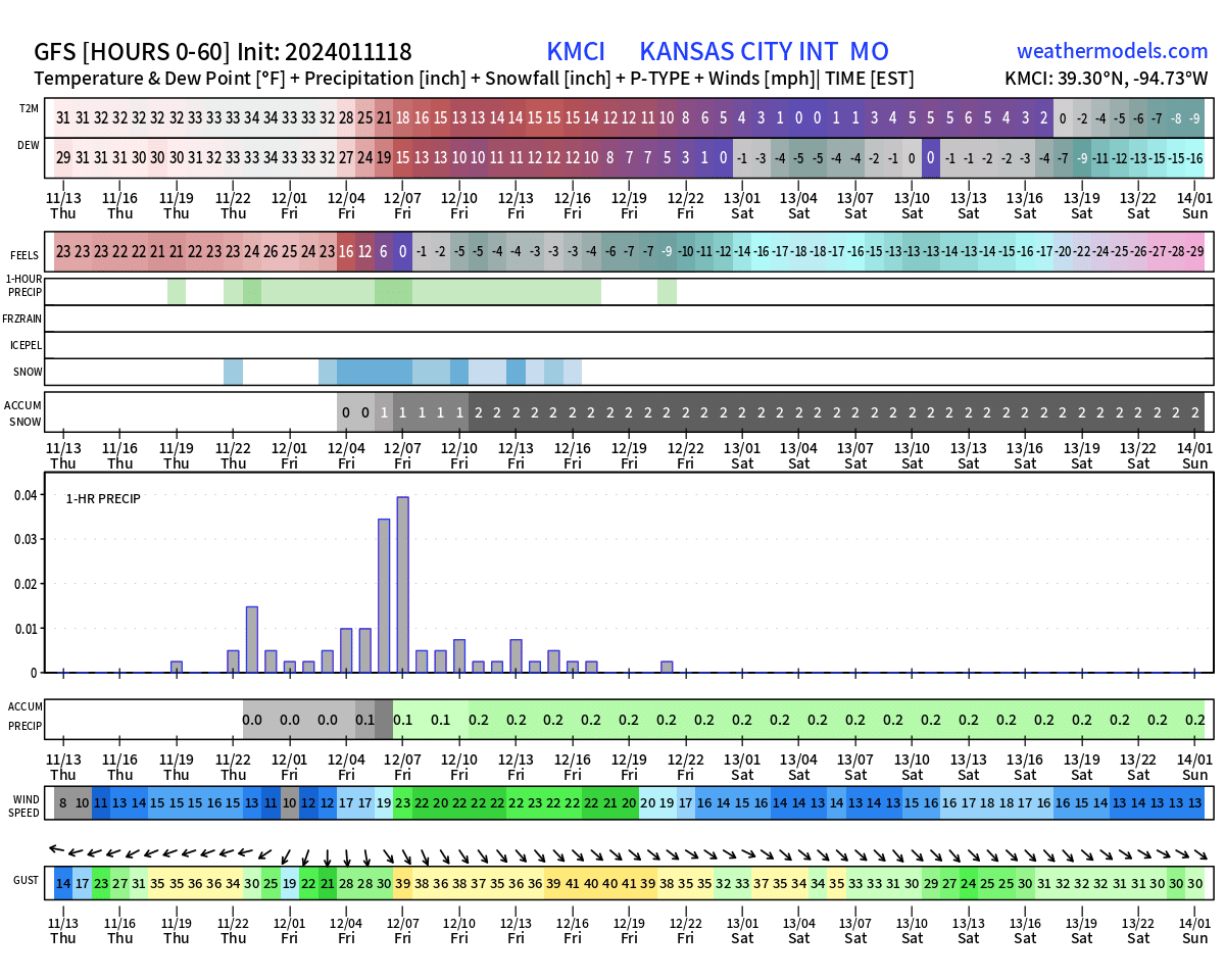
Kansas City Chiefs vs. Miami Dolphins Saturday evening at Arrowhead
Temperatures for NFL Wild Card game will plummet below zero from -4°F to -7°F by midnight EST. Winds out of the NW will be gusty and lead to wind chills into the minus 20s °F. The over/under is 43.5 points.
Blend of Models Forecasts
Friday High Temperatures | January 9, 2024
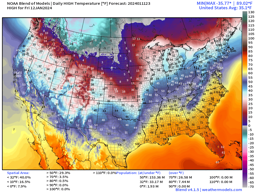
The Southeast in the warm sector of the blizzard ahead of the front will be in the 60s and 70s, plus mid-80s in South Florida. Jealous!
Arctic Blast
Sunday Low Temperatures | January 14, 2024

The coldest actual temperatures will be in Montana in the minus 40s and minus 50s. Subzero temperatures will cover about 1/3 of the Lower 48. Chicago dips below 0°F but folks in Lower Michigan are saved by the much warmer Great Lakes at the cost of Lake effect snowfall.
Monday Low Temperatures | January 15, 2024

Lower 48 average temperature down to 9°F. The single digits make it to Texas. The only warmth hanging on is south of Interstate 4 in Florida.
Iowa Caucus will be starting out in the minus teens to minus 20s °F.
Tuesday Low Temperatures | January 16, 2024

7.7°F Lower 48 average temperature. 90% of the Lower 48 is below freezing.
The Blend of Models in the 7-day + range uses the various global models and ensembles to build temperature forecasts out to 10-days.
Temperature Outlook Next 2 Weeks
Stunning 7-day Average Temperature Anomaly
Week 1: January 11 - January 18, 2024 [EPS Mean 12z]

Week 2: January 18 - January 25, 2024 [EPS Mean 12z]

Snowfall Forecast 10-day EPS Median

With the Arctic blast in place, we will look through the next 10-days at the margins for snowfall chances aside from the Western U.S. where plenty of onshore moisture will pile up on the mountains with feet of snowfall. Once this blizzard moves through
Through 15-days, the chance of 1-inch of snowfall thankfully is very small into Atlanta < 2%.

Coming Down the Pike
Potential Nor’easter early next week. GFS and ECMWF have been flip-flopping with various track and intensity solutions, some of which are significant snowfall for the coastal Big Cities, or a whiff.
Arctic blast #2 … and #3 in 10 and 15 days, respectively.
All maps are probably from weathermodels.com (please subscribe there for affordable, professional, and beautiful weather maps created by yours truly).
Thank you to my paying and freemium subscribers!
Your support pays for my Linux servers and product development. Also, it allows me to provide (usually) interesting and valuable commentary on scientific topics on X. Feel free to say hello and follow on X/Twitter (@RyanMaue)
Old News:
This newsletter will rebrand in 2024 as part of roll out of [WT] https://weathertrader.com
Bad time to be sailing on the Edmund Fitzgerald.