


February 8, 2024 Bomb Cyclone
Powerful Nor'easter more likely early next week
Weather Trader | Thursday Afternoon Update
Bomb’s away!
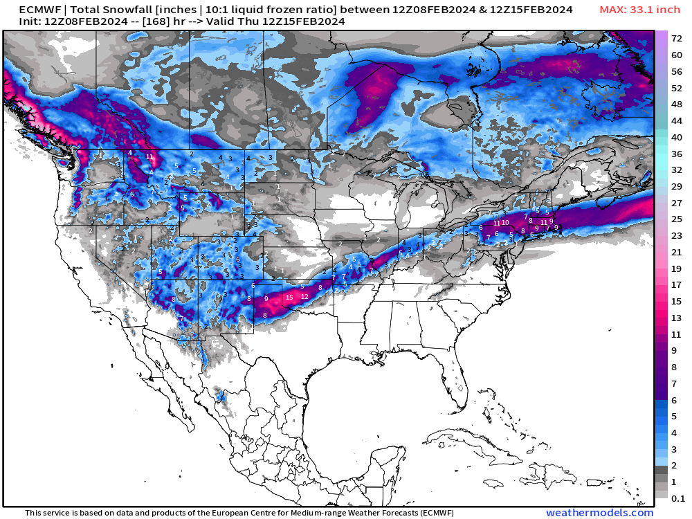
We are within the window of time to be fairly certain of a “bomb cyclone” developing in the lee of the Rockies, slowing intensifying until reaching the East Coast, and then explosively deepening off the coast. The storm will have enough cold air on mid-February to develop narrow snow bands that could be quite significant in North Texas and Oklahoma.

The track of the low will determine if/where and how much snowfall is expected from Texas to New England (obviously) but there is plenty of moisture and enough cold air to produce significant accumulations, at least at night.
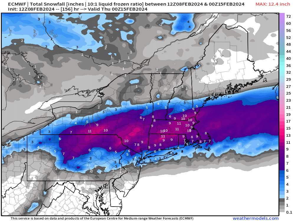
Zoomed in view of the HRES snowfall. This has been moving north/south for the past 2 days of forecasts. Maximum of 12-17” away from the coast with 3”-5” in NYC and 9”-12” in Boston.
Quick look at the GraphCast-ECMWF A.I. (non-commercial/experimental) as a cursory check on the ECMWF’s accuracy. A.I. seems to match up closely at Day 5, which is a good sign since the forecast skill is > 92-95% as of late.
Tuesday morning:

Tuesday afternoon

Looking at Sunday across North Texas = heavy snowfall!

And the resulting snowfall through late Sunday could be significant accumulations from Lubbock to OKC.

Lower 48 Temperatures
Friday Lows | February 9, 2024
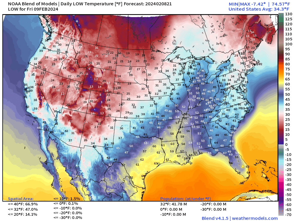
In the 40s and 50s up into Indianapolis for morning lows on Friday.
Friday Highs | February 9, 2024

Wow! Look at the heat wave into Michigan well into the 60s. 70s for almost 60 Million Americans on February 9th. There will be no complaints registered to this meteorologist.
Next 14-days Daily Temperature Anomaly


Not seeing any major blobs of brutal Arctic air for the next 2-weeks even if below normal temperatures pop up for a few days. Running out of winter fast.
7-day Total Precipitation from WPC

Moisture ahead of the “bomb cyclone” will keep the Southeast warm and wet over the next few days. California finally gets a dry spell for the next week.
15-day Snowfall ECMWF EPS Median Accumulation

Since there’s little rainfall/snowfall on the WPC map through Day 7 across the West, you can surmise that heavy snowfall will again come back to California in Week 2 and the entire Western U.S. as we go back to a familiar weather pattern: blocking ridge over Canada and troughs along the coasts.

(Maps from weathermodels.com and weathertrader.com)
Thank you to my paying subscribers! Consider upgrading to a Yearly Plan if you find these updates valuable and wish to support my development at Weather Trader. Here is a little discount valid until February 9th:
In addition, the products that you would typically see at AG2 (old WSI-trader) or other commodity weather services will be available for access. The goal is not to make another weather models site w/a catalogue of millions of updating images, rather provide value-added serves curated to specific verticals e.g. gardening, farming, energy, transportation, tourism.
Also, it allows me to provide (usually) interesting and valuable commentary on scientific topics on X. Feel free to say hello and follow on X/Twitter (@RyanMaue)
Happy to be a paying subscriber. Would like Graphcast maps displayed more. Since Graphcast is trained on historical ECMWF model data, how will that help it in an era where new, changing weather patterns may make the older physics-based models more accurate?