


February 7, 2025 Friday Winter Weather
Get your snow shovels ready in the Northeast

Good Morning!
The next 10-14 days are going to be wild across the Eastern US with multiple powerful storms tracking into the Northeast. A pool of cold Canadian air remains bottled up to the west with a general troughing pattern that allows very warm and moist Gulf of Mexico air to fuel winter storms.
There is a lot of QPF in the next 7-day forecast, and following that into mid-February. Where this falls as snow + temperatures e.g. how much Arctic air is in place = determine the snow ratios and potential accumulations. The ensemble snowfall maps that I create are using the 10:1 ratio as a baseline, you can increase or reduce easily depending upon the lower-level temperature profile. As you head further north into New England, the ratios will be higher, and I’ll show that our snowfall maps from the global models could be conservative!
Temperature Analysis 8:45 AM ET

Only 100 million freezing, but seasonably cold in the Great Lakes.
Temperature Anomaly 8:45 AM ET

Lower 48 Temperature anomaly = +5.0°F above normal.
Parade of Powerful Storms | Next 10-days

Over the next 10-days, you can count the huge storm systems that develop in the southern U.S. and then track Northeast with massive wind fields. Any one of these systems could phase perfectly with the upper-levels and “bomb out” leading to a blizzard. Mid-February is known for major blizzards and Nor’easters. Plenty of uncertainty about each storm in the medium and extended range.
So, let’s just focus on the upcoming systems with better details.
Next 6-days Precipitation Type and MSLP | ECMWF 06z
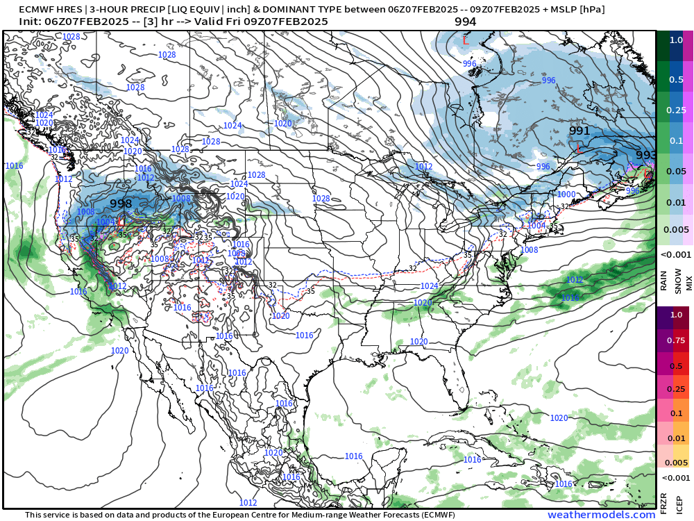
This weekend an area of low pressure develops off the Mid-Atlantic coast and heads east into the Atlantic. Then Tuesday/Wednesday, another storm with snowfall slides eastward off the Northeast coast. By Thursday, the next storm is lined up. These systems are fast moving, but certainly have the potential to dump a lot of convectively driven snowfall.
Total Snowfall Next 6-days (10:1 ratio)
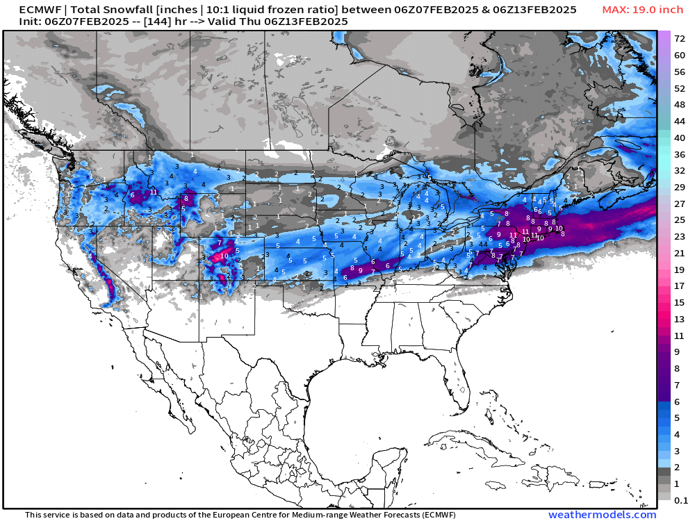
Just in the next 144-hours, we see D.C with 7” NYC with 10” and Boston 8-9” using the 10:1 ratios. However, depending upon the rain/snow mixing and temperatures, we could see more. Note, the upcoming weekend storm won’t dump snow in D.C. — that’s the next one.
Storm Number 1
HRRR simulated radar next 48-hours

By late Saturday into Sunday morning, it will be snowing heavily in New England for a brief period, maybe 6-hours, until the backside of the system in colder air adds more fluff.
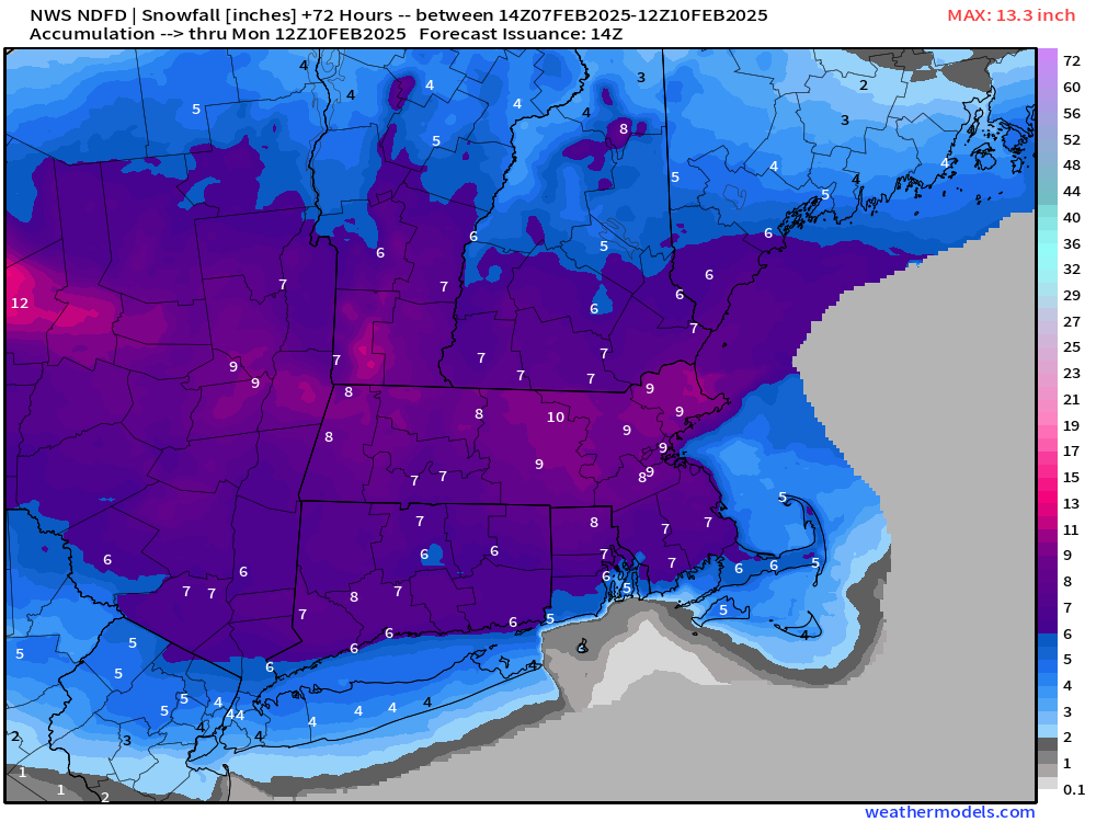
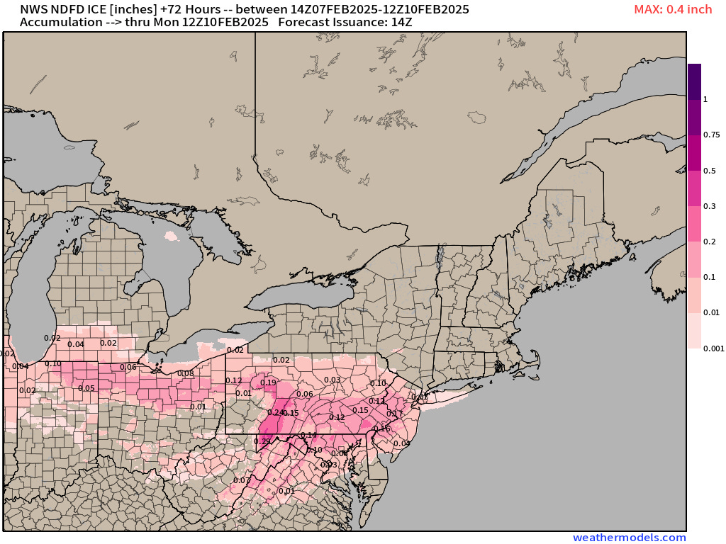
NWS Snowfall and Ice Accumulation Next 72-hours

NWS is at 4” with NYC and 9” in Boston.

And, from the HRRR simulated radar, you saw the freezing rain, sleet, and icing. Not surprising to see more mixed bag precipitation from these storms tracking out of the South.
Precipitation Expected Next 10-days
There is a LOT of QPF in the Tennessee and Ohio River Valleys. Large area of 3”+ and maybe 5” from Nashville into North Georgia.

10-day snowfall totals are impressive even with the 10:1 ratio. You can cross-reference the QPF map e.g. 2”-3” of QPF in NYC and Boston will be partitioned according to the precipitation types and temperature into rain/snow/sleet/ice. Obviously we’re dealing with so much moisture potential!

Probability of at least 12-inches of Snowfall | 10 Days
Love that signal in the Northeast if you’re into snow plowing or shoveling as a business or recreation.

Extend to 15-days | At least 3-inches of Snowfall

75th Percentile of Snowfall Next 15-days

And, Probability of at least 12-inches in the next 15-days

Ensemble Maximum Snowfall during the next 15-days

I only show this map to highlight what happens when multiple storms in one ensemble member slam the same area. There are members that show 42” in NYC and in the 50s into New England.
Keep reading with a 7-day free trial
Subscribe to Weather Trader to keep reading this post and get 7 days of free access to the full post archives.