


February 29, 2024 Enormous California Mountain Snow
Warming trend continues across Eastern U.S.

Thursday Update
Some housekeeping to update everyone on the progress of my development heading into March. Substack as a platform is great for these higher-level newsletters that cover national weather and ongoing extreme events. However, as I’ve mentioned, it’s untenable to send more than one 20 mb sized email every day without filling up your inbox.
There is another publishing platform called Ghost that is self-managed, but contains most of the features of Substack or Wordpress, but allows API posting and other interactions at the command line level to automate various tasks. The customization of the site is also much more intricate than Substack. Ghost also manages subscriptions, and can send emails. Regardless, I’m not going to ditch Substack but use the Ghost platform hosted at Weather Trader in order to host products that will be only accessible to subscribers. Moreover, we will be launching Forecast Points, which will be a PDF (or HTML page) of your local and state/regional weather forecasts, maps, and data. This will be an extensive offering with “everything under the sun” imaginable for your location of choice including NWS, NWP model, and A.I. modeling output, maps, and tables/charts of recent weather, climatology, and short, medium, and long-range forecasts. This will join Forecast Farm, Weather Trader, and perhaps additional projects, if I get some help! My dream project [close to MVP stage] is still on the horizon — but I need the capital to accelerate my efforts — if that’s possible, then by all means email me, otherwise I am a one-person operation (for now.
Your subscriptions make this effort possible, and I’m extremely appreciative. This project is the culmination of my more than 12-year private sector career in meteorology, mainly handling weather model data.
As I mentioned yesterday, ECMWF announced the arrival of their AIFS artificial intelligence modeling system, which I quickly gobbled up and processed along with the other A.I. models here at https://climatlas.com/temperature/graph/ including Pangu, GraphCast, FourCastNet, FuXi, and now AIFS.
ECMWF is also providing more “open data” at 0.25° grid spacing to run the A.I. models and WRF, which will be a huge deal for me (!)
Copernicus Climate Pulse
The European Union’s climate monitoring agency has created a handy website with ERA5 reanalysis temperature/anomaly for the globe. Link.
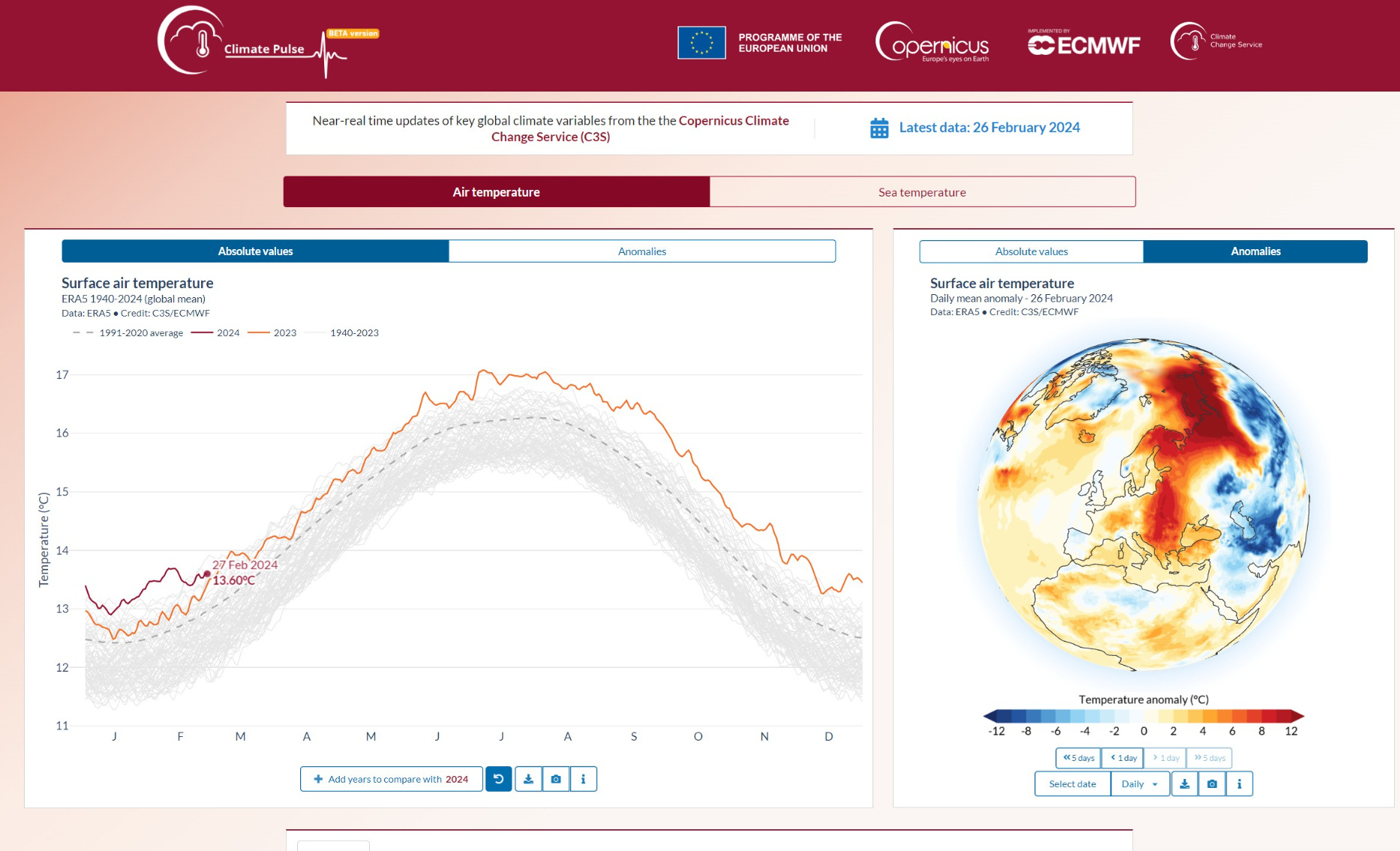
Years ago, I called this the Earth’s EKG. I’ve been the biggest proponent of reanalysis based temperature monitoring. From Twitter: Link.
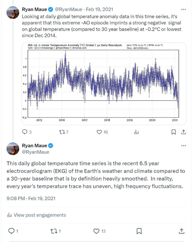
These updated charts are circa 2007 vintage coding, but have worked well over the years with JRA55 and now JRA3Q. Website at Climate Atlas.
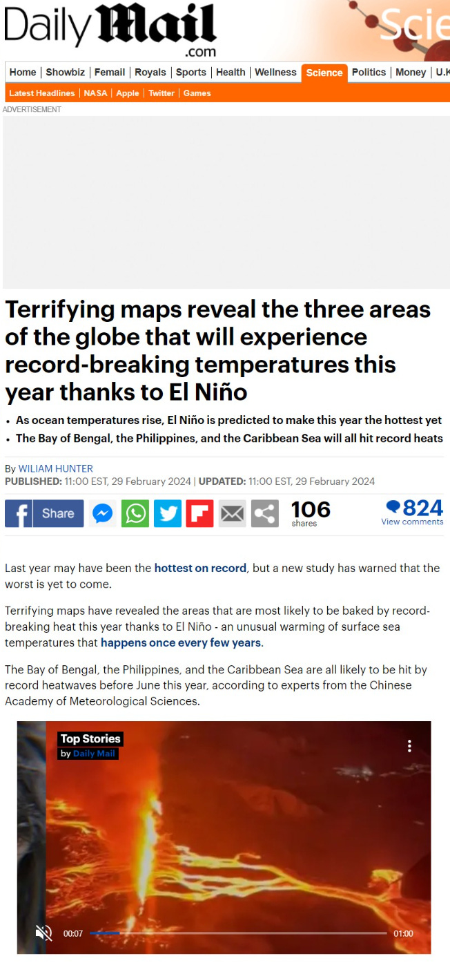
Daily Mail and other outlets have been irresponsibly reporting (if you want to call it that) on the global temperatures in the coming months. However, it’s garbage because we are transitioning rapidly from El Niño to a La Niña, and it should be rather strong. That will knock back global temperatures to pre-May 2023 levels.
Friday Low Temperatures | March 1, 2024

The coldest air is just lurking in Canada with well below zero temperatures Friday morning. However, that brutal Arctic air will not be coming down to the Lower 48. Instead, a sustained warming trend into the weekend is on the way.
Friday High Temperatures | March 1, 2024

Back into the 40s solidly across the Midwest and Great Lakes.
70s in Texas. Not a big fan of the “wedge” in the 40s in North Georgia.
Weekend | Saturday March 3, 2024

Back to Spring in the Plains and into Chicago, with 60s and 70s. March coming in much above average for both temperature and precipitation.
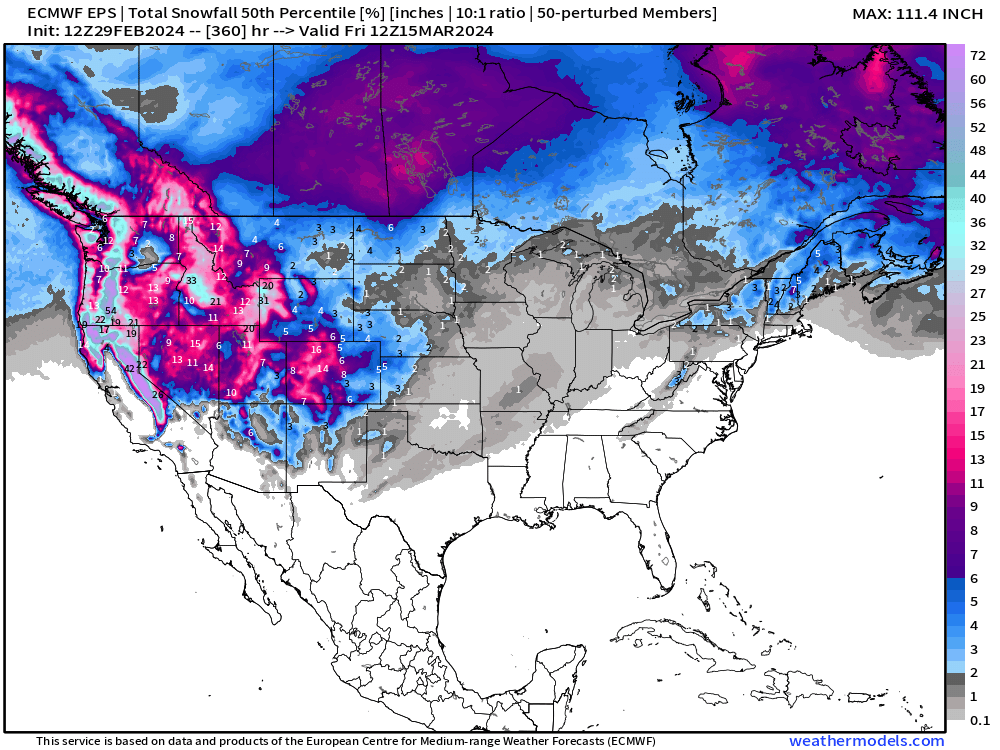
Extreme California Precipitation


Check out Interstate 80 — the blue line connecting the 114 and 60 through the Sierra. NWS NDFD has a maximum of 183 inches of snow — that’s more than 15-feet in the next 72-78 hours. Yikes!
WPC 7-Day Precipitation
Boatloads of rain for the Southeast as the subtropical jet brings moisture laden air across the southern tier and combines with Gulf of Mexico disturbances.


California precipitation totals — which will fall as snow — of almost 12-inches = 15-feet or maybe 20 feet of snow. Insane!
Extending out 15-days | EPS Ensembles
This map goes through the 15th of March, and there’s a light gray color of ~0.1” across the central U.S. from a brief chance of snowfall, but that is not impactful.
Gone is the Lake Effect snow chances, perhaps for good this winter.
Meteorological Spring starts on March 1st.
More Ensemble Clustering Tools at Weather Trader
Leap year offer to upgrade to annual subscription. I’m really hoping you’ll stick around for the Spring and Summer, especially Hurricane Season!
(Maps from weathermodels.com and weathertrader.com)
Thank you to my paying subscribers! Consider upgrading to a Yearly Plan if you find these updates valuable and wish to support my development at Weather Trader. As you can see, your support has paid dividends with considerable progress made to launching Weather Trader at full-tilt. There is still some work to do in the coming days/weeks. Also, it allows me to provide (usually) interesting and valuable commentary on scientific topics on X. Feel free to say hello and follow on X/Twitter (@RyanMaue)
THanks! I always appreciate when you share maps, provide the purpose of the maps, and give us an idea of where to find them. GREAT WORK. I have been following you for years!
Looking forward to the new systems.