


February 28, 2024 Cold Front Blasts Eastern US
ECMWF AIFS data now available

Wednesday Update
ECMWF has launched their Artificial Intelligence version of IFS called AIFS today with 15-day forecasts available 4x per day initialized off the IFS analysis. This is a HUGE day for weather modeling as we will have free and open-access to the best A.I. trained model data.
The ECMWF AIFS is currently trained on the ERA5 reanalysis using a similar technique to the Google Deep Mind GraphCast, but in the recent weeks/months, the configuration has evolved to a new type of transformer.
In a blog update, they show the improved skill scores over GraphCast. I will be collecting the data to perform verification and provide products to the public including incorporation into the Clusters at Weather Trader.
You can see the updated A.I. models here at https://climatlas.com/temperature/graph/ including Pangu, GraphCast, FourCastNet, FuXi, and now AIFS.
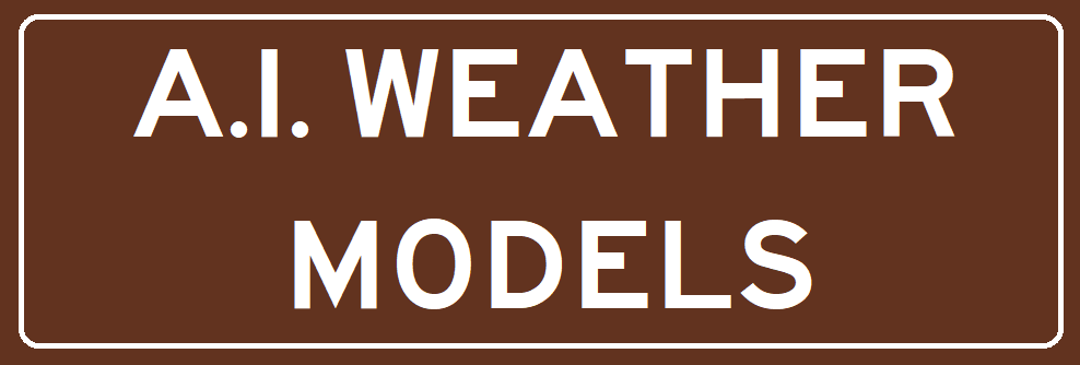
I collected the forecast data and generated a quick 15-day animation of temperature anomaly through March 14th to show the continued warmth expected across the Lower 48 — in general — with brief waves or shots of colder Canadian air intermixed. However, when averaged across the 2-weeks, most definitely a “much above normal” signal.
Thursday Low Temperatures | February 29, 2024 | Leap Day

Check out the extreme cold air bottled up across the Great Lakes and into Canada with lows in the -20s. However, that cold air is not crashing into the Lower 48 much further, instead to be replaced by much warmer southerly flow.
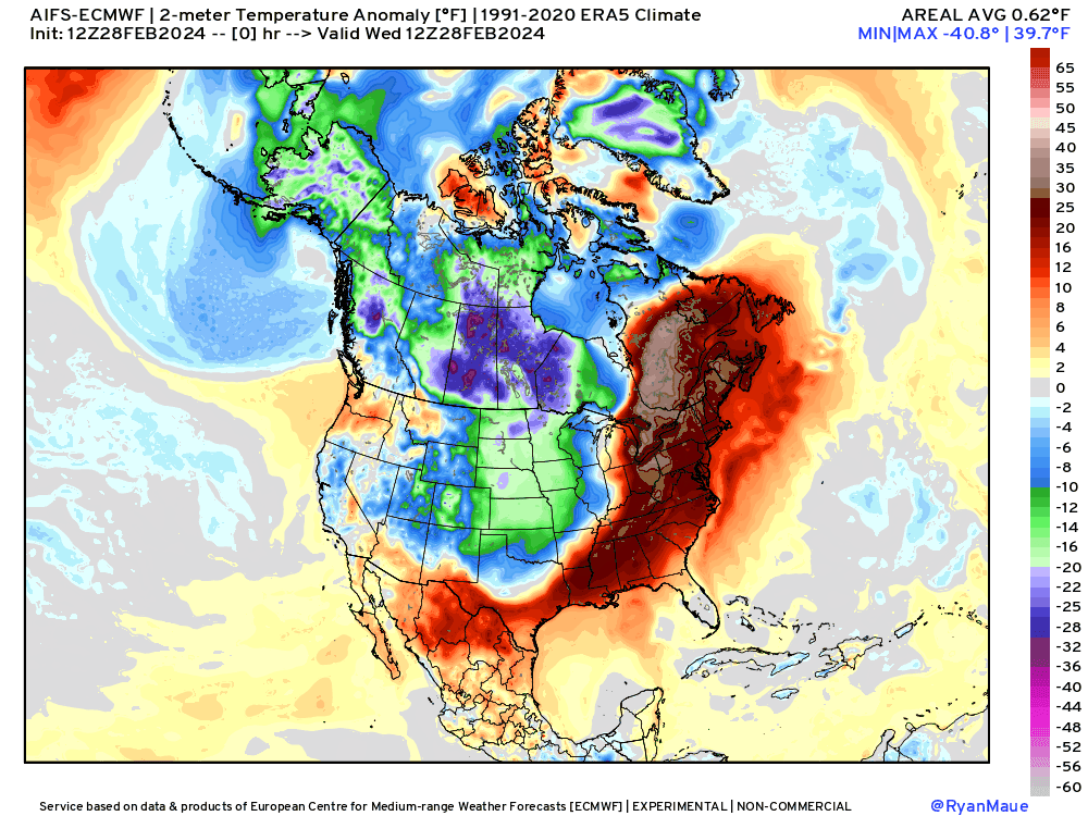
Thursday High Temperatures | February 29, 2024 | Leap Day
Daytime temperatures moderate nicely on the final day of meteorological winter, but still chilly in the 40s in North Texas. However, zoom ahead to this weekend:
Next Weekend | Saturday and Sunday March 3-4, 2024

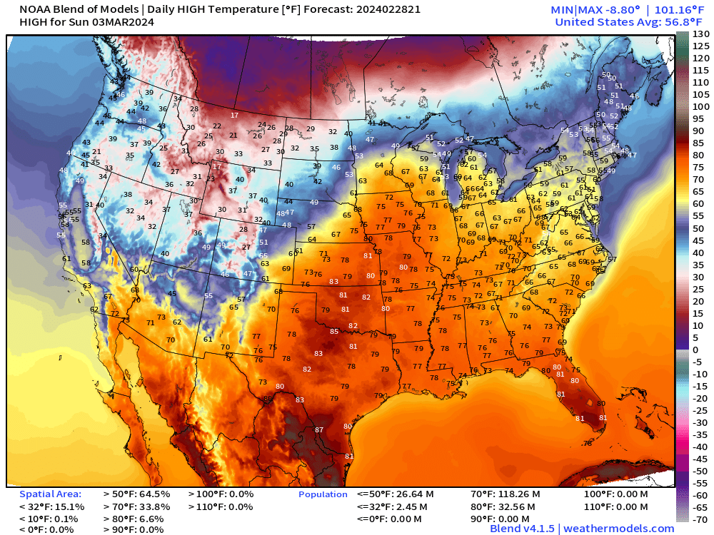
Back to Spring across the Eastern U.S. with 70s back into the Midwest including Chicago. Let’s assume the temperatures are underdone like this last Spring Fever and hopefully add 5°F to these numbers across the Great Lakes.
Extreme California Precipitation
Another 7-trillion gallons of rainfall (or equivalent snowfall) for California, and 4 Trillion for Oregon, and 2.5 Trillion for Washington during the next 7-days.
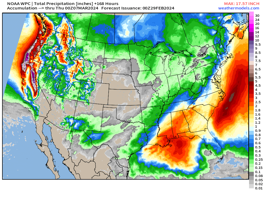

Also, the Southeast remains wet with some sort-of-tropical systems snuck under a ridge.
Note the direction of travel of the Lows off the West Coast dipping southward from the Gulf of Alaska. That is a cold air origin, of course, and is not the “Pineapple Express” atmospheric rivers we are used to with El Nino.
This weekend, a system with plenty of Gulf moisture drenches the Southeast. However, another one shows up in 7-8 days on a similar track. We’ll see if an out-of-season subtropical storm could form — it’s possible.
As long as the southerly flow continues east of the Rockies, then winter goes back on hiatus — and we’re running out of clock for strong winter storms. Instead, we change our focus to severe weather season.
Extending out 15-days | EPS Ensembles

This map goes through the 14th of March, and there’s a light gray color of ~0.1” across the central U.S. from a brief chance of snowfall, but that is not impactful.

The extreme snowfall over the next 3-days occurs across the Sierra > 11-feet.
Also, some significant Lake Effect snow continues behind the Arctic front before melting as temperatures warm back to Spring Fever levels.
More Ensemble Clustering Tools at Weather Trader
Leap year offer to upgrade to annual subscription. I’m really hoping you’ll stick around for the Spring and Summer, especially Hurricane Season!
(Maps from weathermodels.com and weathertrader.com)
Thank you to my paying subscribers! Consider upgrading to a Yearly Plan if you find these updates valuable and wish to support my development at Weather Trader. As you can see, your support has paid dividends with considerable progress made to launching Weather Trader at full-tilt. There is still some work to do in the coming days/weeks. Also, it allows me to provide (usually) interesting and valuable commentary on scientific topics on X. Feel free to say hello and follow on X/Twitter (@RyanMaue)
Thanks for clueing us in on the ECMWF AIF. This looks to be a great resource!