


February 26, 2024 Record Warmth
Temperatures soaring across the central Lower 48 for another day

Monday Update
Temperatures soared into the mid-90s in Texas, and into the 70s as far north as Minnesota including Chicago. The overall forecast was underdone/underestimated with temperatures 5°F warmer today than expected just 48-hours ago. This warmth will translate into Tuesday before a strong Arctic front erases the mid-70s in Chicago with teens and subzero wind chills.

The temperatures should be in the mid-30s in Iowa on average for middle of the day on February 26, instead in the mid-70s or 40-45°F above average. Des Moines February record was 78°F back in 1930, and it looks like Monday could tie that mark.

Tuesday’s highs will be warmer yet ahead of a strong cold front with the developing winter storm. 80s into St Louis. Colder air behind the front sweeps into the upper Midwest with teens in the Dakotas. The circles on the map are forecast record highs — obviously 70s and 80s are definitely daily record highs, and surely some monthly highs will be included depending upon the location.

Chicago in the mid-70s with 70°F into Grand Rapids, Michigan.

Next Weekend | Saturday March 3, 2024
The warmth returns next weekend again.

Weather Trader is a reader-supported newsletter emailed to inbox 1-2 times per day with unique, data and visualizations/maps to tell the weather/climate story. To receive new posts and support my work, consider becoming a free or paid subscriber [20% off through Leap Day].
Pacific Moisture feeds progressive pattern eastward

The upper-level pattern will quickly drag the moisture from the Pacific NW across the Rockies into the Midwest to feed a developing winter storm. The low pressure will actually mature in Canada so the overall impacts to the Great Lakes are much less significant than just expected 48-hours ago. Any snowfall will be brief with minimal accumulations. The main impacts will be heavy rain, and then a dramatic drop off in temperature with gusty WNW winds. There is a slight chance of severe weather.
Midwest and Great Lakes Storm System on Wednesday

   ...THERE IS A SLIGHT RISK OF SEVERE THUNDERSTORMS FROM EAST-CENTRAL
   MISSOURI INTO ILLINOIS...INDIANA...NORTHWEST OHIO...AND SOUTHERN
   LOWER MICHIGAN...

   ...SUMMARY...
   Scattered strong to severe thunderstorms, associated with large hail
   (some near 2 inch diameter), damaging gusts, and a few tornadoes
   will be possible from late Tuesday afternoon, into the evening and
   overnight from parts of the mid Mississippi Valley to the Ohio
   Valley and southern Lower Michigan.
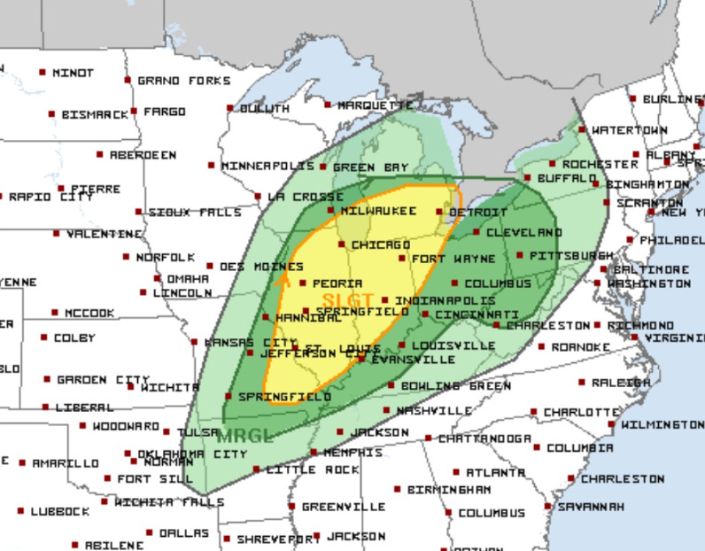
Ahead of a powerful cold front, a slight chance of severe weather is possible from St. Louis through Chicago and Indianapolis on Tuesday. Temperatures will crash behind the front, but not much snow is expected. Overall, 1-2 inches of rainfall could fall in the Ohio River Valley.
NWS Snowfall Next 3-Days

Extending out 15-days to the Ensembles | % of 3” or More
Keep reading with a 7-day free trial
Subscribe to Weather Trader to keep reading this post and get 7 days of free access to the full post archives.