


February 23, 2024 Spring like warmth into Midwest by Tuesday with near 70 in Chicago
Very powerful Storm system develops Tuesday but not much snowfall

Friday Evening Update
Quite weekend with a bit of a cool shot in the Southeast for Sunday morning with freezing temps into Atlanta. The last average freeze is around March 21, the first day of spring, and I’m hoping we’re not going to do the “late freeze” to kill my blossoms like the last couple years.
The late February sunshine will be quite warm with 70s building into the Plains Saturday and Sunday. And, then even warmer into Tuesday in Chicago, pushing 70°F.

Weather Trader is a reader-supported newsletter emailed to inbox 1-2 times per day with unique, data and visualizations/maps to tell the weather/climate story. To receive new posts and support my work, consider becoming a free or paid subscriber [20% off through Leap Day].
Winter Storm Tues-Wed across Great Lakes
Looking at the 10-day ECMWF precipitation type forecast:
Powerful low pressure tracks through the Great Lakes dipping to around 970 mb. There is a LOT of moisture from the Pacific and subtropics, but limited cold air, and fast movement means not much snowfall accumulations. However, the main threat looks like gusty winds, potential severe weather, and heavy rainfall over the Eastern U.S.
Then, toward the end of the 10-day forecast run, a powerful Colorado system could develop. No guarantee, but that’s the upper-level timing in 9-10 days for the next major weather maker = Sunday, March 3.
Pacific NW and California will be under onslaught of atmospheric rivers again throughout the entire next 10-days especially in Washington.

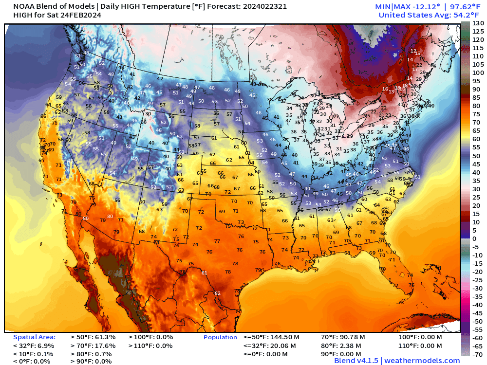
Blend of Models High Temperature Next 8-days:
Except for a brief shot of cool air late Sat into Sun morning across the Southeast, the eastern Lower 48 goes into Spring Fever mode through middle of next week, before another cold front sweeps through. But as we move into March, these fronts don’t have much lasting power in terms of cold air, and quickly moderate back into the 60s.
Winter Storm Wednesday morning
This is a powerful storm system with access to the upper-level jet dynamics. 972 mb is quite low for an over land system. However, this is the end of February and just not enough cold air to generate the typical crippling blizzard scenario we’d see 3-weeks sooner. Winter is on the way down the drain.


Tuesday: 68°F in Chicago — a cool down — then back into the 60s by first week of March.

7-day HRES snowfall forecast:
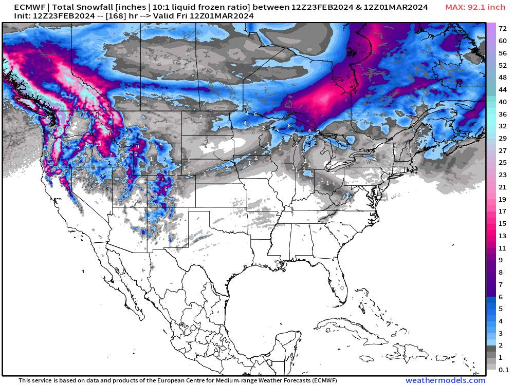
The snowfall from the powerful winter storm remains up in Ontario. But some light brief accumulations across the Midwest and Great Lakes, otherwise.
Extending out 15-days to the Ensembles:
No update here: Median shows a whole lot of “not much” except 1”-3” of light snow accumulations in the Midwest, Great Lakes, and Northeast. Still no sign of a Nor’easter or a blizzard quiet yet, but that’s not expected when it’s in the 60s in Chicago.

This is the companion 15-day Median Precipitation Map:
Important for the upcoming Spring agriculture/Forecast Farm daily updates. We will provide a local/regional/national view of rainfall percentiles and probabilities.
The Southeast is under a wide area of 3-4” of rain in 2-weeks extending into the Ohio Valley and Northeast. Plenty of rain.

Daily Temperature Anomaly | 5-day Chunks | Next 15-days
No update: Using the degree day method daily (TMAX+TMIN)/2.0, we see an enormous 15°F above normal signal, which only then moves NE in Days 11-15.
Still wondering who is predicting a return to winter — and when. I guess the second week of March. Hopefully I’ll be at Home Depot looking for flowers.


How about the Ensemble Clusters?

This is all 103-ensemble members from GEFS, ECMWF, GEPS (Canada) for Day 10.
East of the Rockies across all the ensembles = blood red = very warm relative to a background climatology that is quickly increasing heading into the 2nd week of March.
More Ensemble Clustering Tools at Weather Trader
Leap year offer to upgrade to annual subscription. I’m really hoping you’ll stick around for the Spring and Summer, especially Hurricane Season!
(Maps from weathermodels.com and weathertrader.com)
Thank you to my paying subscribers! Consider upgrading to a Yearly Plan if you find these updates valuable and wish to support my development at Weather Trader. As you can see, your support has paid dividends with considerable progress made to launching Weather Trader at full-tilt. There is still some work to do in the coming days/weeks. Also, it allows me to provide (usually) interesting and valuable commentary on scientific topics on X. Feel free to say hello and follow on X/Twitter (@RyanMaue)
The last two days, your formatting has changed requiring me to scroll horizontally in order to read the email. Previous emails did not do this and fit within my Outlook window. I can send screenshots if that would help