February 17, 2025 Monday Weather Update
Extreme record breaking cold this week across central Lower 48
Good Evening!
Over the next 5-days, the extremely cold pool of continental polar air over Canada and Montana will slowly drain southward with very high pressure (> 1050 mb)
Temperatures will be 30-50°F below average over many days especially over the central Plains.
And, it some cities like Omaha, Nebraska and Oklahoma City, all-time coldest/latest record lows will be set. That means “unprecedented” cold this late in Winter. These stations have complete temperature records back into the 1870s or 1880s.
The Polar Vortex reforms over Hudson Bay at maximum intensity for this winter. The thickness is extremely low — meaning the tropopause is very low as well.
500 mb Temperatures are in the -50s °C which is quite exceptional. This might be the most intense I’ve seen the PV in my 25-years of weather model watching.
Animation through 15-days … picks up the amazing “white fuzzball” spinning over eastern Canada. This next Arctic blast may be entirely Northeast US for a change from the Plains.


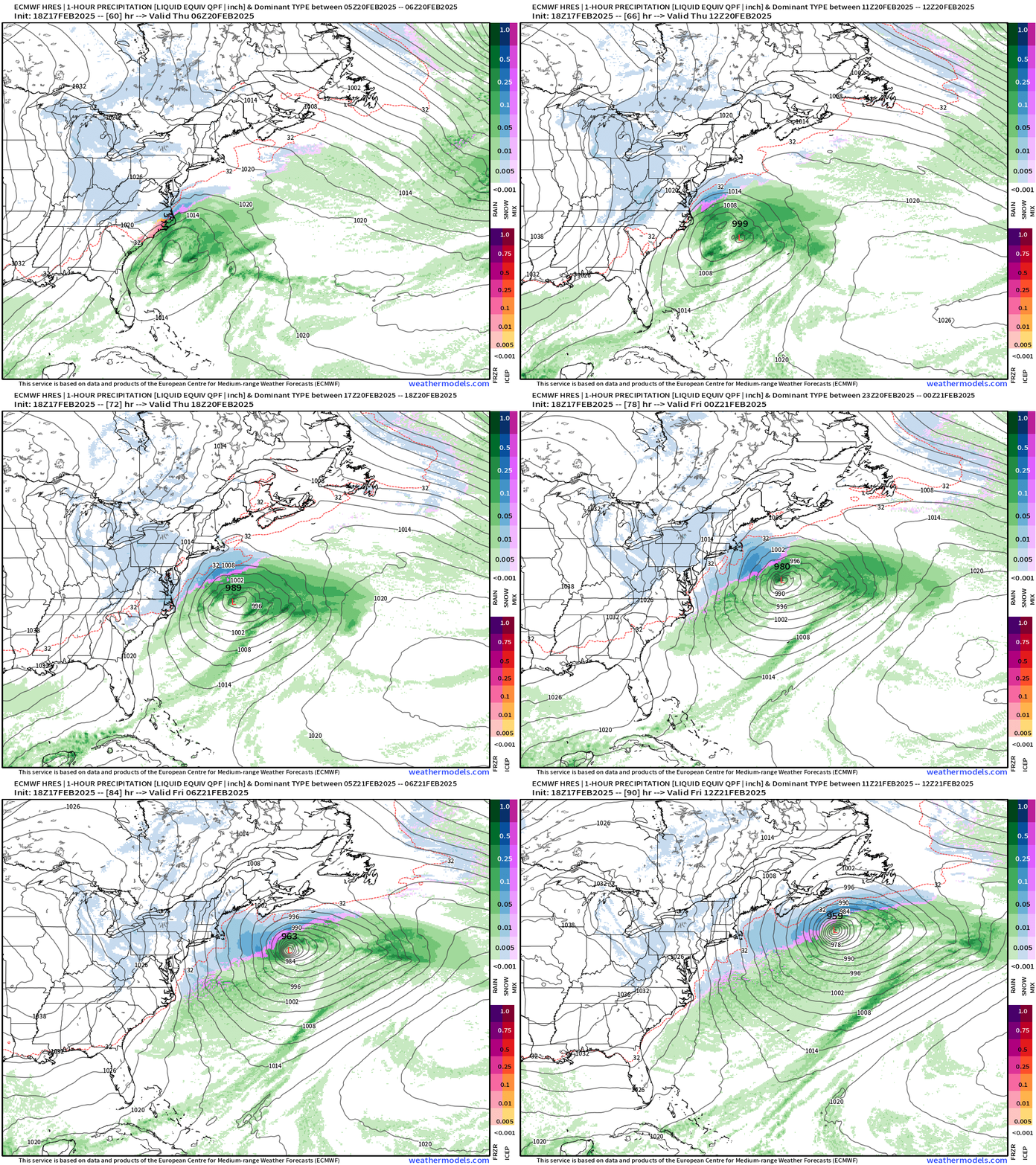
ECMWF Precipitation Typed QPF through 90-Hours
Our winter storm gathers later on Tuesday across Kansas, Oklahoma, and Missouri before moving east — quickly — off the Carolinas coast.
Then, the system undergoes rapid intensification (bomb) to the 950s mb
However, almost all of the precipitation remains just enough off the Mid-Atlantic and New England coastlines to keep the Big Cities mostly unbothered.
However, where the impacts will be most severe will be North Carolina and the DelMarVa.
However, compared to just yesterday, the overall QPF including snowfall and freezing rain has reduced significantly. That’s a good thing, of course. The models have performed poorly for this event.
The highest snowfall p-typed QPF is maybe 1-inch now.
And, that should equate to about 10-inches of snowfall in eastern North Carolina.
Freezing rain amounts are half of what they were yesterday, but still could be damaging!
Thank you to my community of subscribers and supporters. If you’ve enjoyed the Winter 2024-25 so far, and want to see more weather maps and analysis for the coming Spring and Summer, then please consider upgrading to a paid / annual plan. That helps me secure additional computing resources and dedicate more time and effort to this growing enterprise. 20% off coupon through February 19.
Keep reading with a 7-day free trial
Subscribe to Weather Trader to keep reading this post and get 7 days of free access to the full post archives.


