


February 15, 2024 Thursday Update
Clipper systems line up for nuisance snowfall

Thursday Afternoon Update
There’s quite a bit going on across the Lower 48 with weather systems from coast to coast. The Alberta Clipper systems cruising across the Northeast, and then Plains to Mid-Atlantic are not particularly strong but enough moisture to drop impactful snowfall — that won’t stick around long — too warm.
Heavy rain into the West Coast again by mid-Saturday, just the beginning of another atmospheric river onslaught. Temperatures will briefly chill behind a sort-of Arctic front, but moderate again quickly. We’re running out of winter fast.

Clipper Systems
NWS accumulated snowfall over the next 72-78 hours:
1-3” across several states that have been rather snow starved this winter. Even 3-inches now expected in Washington D.C.
Only 1-inch or so in NYC and Boston from these Clippers.
Continued heavy lake effect/enhanced snowfall in Michigan. My family is enjoying the snowfall, I think.
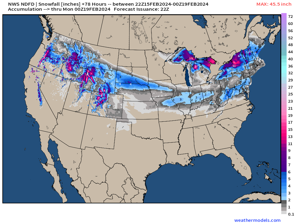
Next 24-hours (First Clipper system): Could be 6-10” in upstate NY and higher elevations of New England.

Total is up for 72-hours: Might be 18-inches downwind of Ontario.

We’ll see how this forecast performs: 3-inches in D.C.

Next 7-Days Surface Weather Pattern
After these Clippers move through quickly, fair weather dominates into next week east of the Rockies. Meanwhile, atmospheric rivers with two storms blasts the West Coast especially central California.

One of my favorite parameters is Integrated Vapor Transport (IVT) to show the location and intensity of atmospheric rivers. Two significant episodes: Sunday and next Tuesday.

Warming Pattern into March
No update here:
During the next 2-weeks, after brief shots of Arctic air in the Great Lakes and Northeast, a substantial warming pattern takes over North America and the Lower 48 to end February. We’re quickly running out of winter.
More Ensemble Clustering Tools at Weather Trader*

I created more Clustering Tools — as well as a 4-panel pane of the ensembles from ECMWF EPS, NOAA GEFS, and Canada GEPS + the 103 member mean in the animation above.
The Barney purple here is about -15°F to -20°F compared to normal, so not exactly exceptional Arctic cold heading into next week, but that is quickly wiped away with much above normal warmth.
Rather than posting every map, you can see these Clustering Tools freely at WeatherTrader.com: and continue to support these products (which will earn any subscriber to this Substack a golden ticket into the Weather Trader interface as founder/supporter, and friend of Ryan)
Lower 48 Temperatures
Friday Lows | February 16, 2024
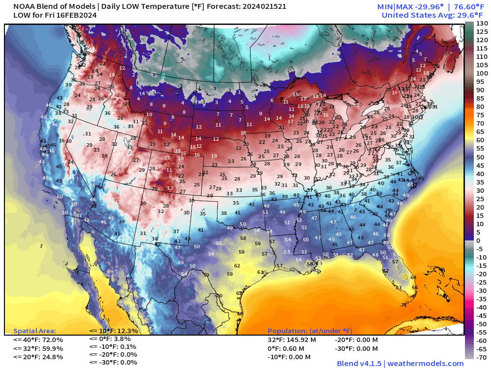
There is actually sub-zero air leaking into the Lower 48 but only 600K population affected. Seasonable 20s across much of the Great Lakes into the Northeast.
Friday Highs | February 16, 2024

Still quite warm in the 70s from Texas to Southeast. Almost 50-milllion Americans enjoying the 70°+ warmth.
7-day Total Precipitation from WPC

The atmospheric rivers will dump considerable rainfall on California! We’re at 6-trillion gallons instead of 8T from yesterday’s forecast.
15-day Snowfall ECMWF EPS Median Accumulation

If you eyeball the 3-day NWS NDFD maps, and then look at the 15-day median from the ensembles, then you’re probably looking at “not much” added to the Lower 48 east of the Rockies during the next 2-weeks. No surprise considering the exceptional warmth.
Western U.S. will continue to be buried!
(Maps from weathermodels.com and weathertrader.com)
Thank you to my paying subscribers! Consider upgrading to a Yearly Plan if you find these updates valuable and wish to support my development at Weather Trader. Here is a little discount valid until February 20th:
Also, it allows me to provide (usually) interesting and valuable commentary on scientific topics on X. Feel free to say hello and follow on X/Twitter (@RyanMaue)
*Information about Clustering Tools
As part of new development tools that you’d typically pay a ton to view, I’ve posted in real-time a large selection of clustering tools. Please overlook the table of contents presentation on the website at Weather Trader, as that’s the final task to make a functional website.
The following is 153 ensembles from the last 3 00z/12z EPS ensemble cycles valid on Day 14 or February 27. I use 4 clusters of the 500 hPa height pattern (EOFs) and then composite temperature anomaly from the various ensembles. This is a lagged ensemble clustering approach.
This version uses the most recent model cycle (12z) but 3 different ensemble systems including the ECMWF EPS, Canadian GEPS, and NOAA EFS. There are 103 members and they are binned into their respective clusters.
We can then composite other variables including precipitation (anomaly), degree days, and height patterns in order to diagnose the various possible future Day 14s. Also, this is repeated for Asia, Europe, and soon Australia and South America.