


February 12, 2025 Wednesday Winter Weather
Extreme cold from Polar Vortex events next week

Good Wednesday Evening!
Noticing the days getting longer with daylight after 6 pm ET, which is one sign that Spring is around the corner — a very long corner. The Polar Vortex has loaded up across Ontario, Canada — and is ready to dump a load of cold continental polar air onto the Midwest and Great Lakes. Unfortunately, signs that the Arctic blast might be even more severe than anticipated as “worst case” just a few days ago.
GFS Dynamic Tropopause
Next 5 days: the little white fuzzball (very cold vortex) on the tropopause swirls around Hudson Bay and then dips into the Great Lakes, elongates, and then gets ready to swing through like a pendulum after Day 5.

For 15-days from EPS 00z (ECMWF had a huge network outage this morning) we can see an astounding cold pool dipping into the central U.S. before moderating and pushing east. The coldest air of the winter looks likely in the upper Midwest into the Great Lakes.

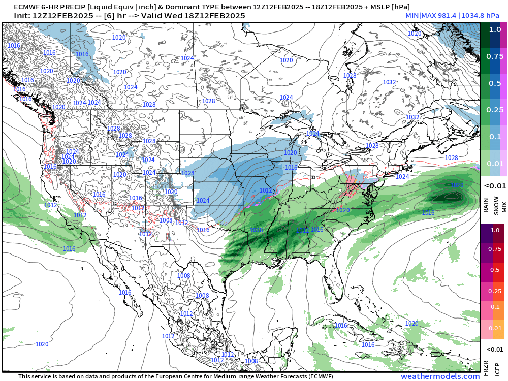
Back to short-term weather … HRRR Next 48-Hours

A major atmospheric river arrives into California on Thursday.
Winter storm system tracking out of the Central Plains into the Great Lakes: brief bout of snowfall swings through Chicago and Detroit. Heavy rain continues across the Southeast with potential for severe thunderstorms.
Weather on Wednesday Evening
Current frontal positions but for weather until Thursday morning.

Weather on Thursday

Amazing atmospheric river to crash into California.
NWS Precipitation Totals next 66-hours


Huge precipitation in the Sierra > 10” = more than 10-feet of snowfall.
NWS Snowfall Next 66-hours

Two storms in the Great Lakes | First 24-hours

Then, add up another storm system for the 66-hour Totals: 10-12” across Michigan, which does not need any more snow.

Most Recent 6-Days ECMWF Model Update (12z)
Thickness field shows the “Polar Vortex” as the gray (lowest thickness) over southern Canada (Ontario) dipping into the Great Lakes and elongating. Sometimes looking at the actual fields is much more informative than height anomalies!

Precipitation Type | Next 180-hours
There’s the weekend storm system for the Great Lakes — and somewhat in the Northeast. The Big Cities will escape with just rainfall.
Monday Morning
Huge “blizzard potential” bomb cyclone just north of Maine with very strong winds associated with the lobe of the Polar Vortex

Deep Freeze Monday Morning Temperatures

Total Snowfall Through 5-days on Monday morning

Monday Morning Temperature Anomaly
30°F to 35°F below normal in the Midwest and Great Lakes

Tuesday Evening at 7 PM


Brutal Cold and Temperature Anomaly for the central U.S.
Keep reading with a 7-day free trial
Subscribe to Weather Trader to keep reading this post and get 7 days of free access to the full post archives.