


February 12, 2024 Winter Storm
Tracks shifts south increasing snowfall for NYC
Weather Trader | Monday Noon Update
Yay! Now a Substack “Best Seller” and approaching 3,000 [free and paid] subscribers via email. Not bad for 6-months and I’m very grateful for paid subscribers who have essentially funded all of my development time and resources to build Weather Trader’s products. So much more to come.
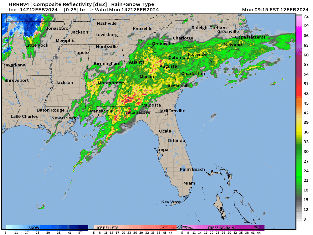
Heavy rain continues across the Southeast for the next 6-12 hours as the storm system tracks quickly off the East Coast.
On the back side of the Low, overnight, some snowfall could fall in eastern Tennessee as temperatures fall. The snow will be rather brief.

The ECMWF 06z continues the trend of offshore track movement of the low pressure. This is actually a very muted precipitation and snowfall forecast from ECMWF that is significantly less than what the NWS is calling for — and that has adjusted markedly from Sunday.
We’ll be watching the 12z ECMWF for either a counter adjustment to the north again, but right now, there is a small bust signal — too much QPF and snowfall inland New England, but 06z could be trash.

NWS QPF is 1.0-1.4” including NYC and Boston. So, depending upon the snow-liquid ratio (SLR) could get 6-inches of very wet heavy snow or 14-inches of lighter variety.
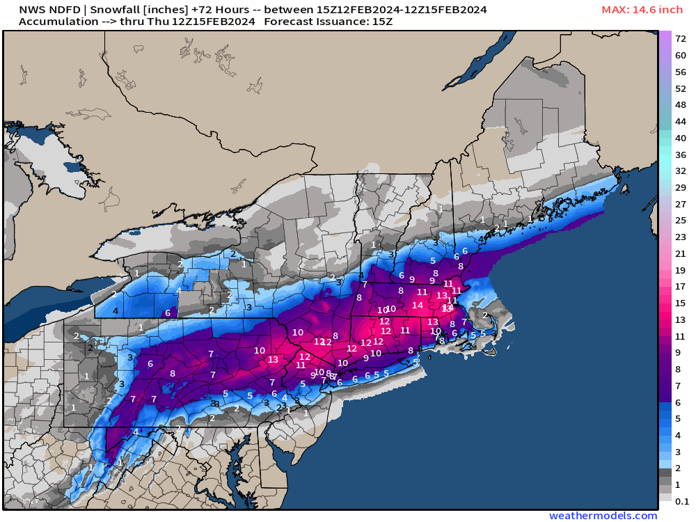
The NWS snowfall forecast is impressive with a large area of 12-inches+ across PA to MA with 8-11” from NYC to Boston. This is most certainly the most snowfall in NYC forecast in 2-years for Tuesday (Election Day).

The HRRR 12z meteogram is a great, highly detailed way to show the forecast at a point through the next 18 or 48 hours. NYC has 8-inches of rain with 1.5” of QPF with a transition from rain to ice pellets and then snow during the morning on Tuesday.
I’ll be providing a whole library of these “point forecasts” at Weather Trader so please subscribe. You’ll really like the concept e.g. think weather dot gov updated into the 2020s.

GFS 12z arrived with the same 1.5” QPF but either rain or snow, adding up to 11-inches using a dynamic ratio. Tuesday morning will look like the NWS Cold Icon below — the hipster in a skirt trudging through the snow in 1960s Manhattan.

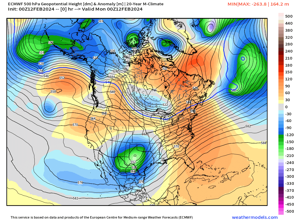
Looking down the pike at the next 10-days total from ECMWF 00z HRES and there was supposed to be a pattern change to colder and more wintry conditions. However, the most recent guidance has shifted to ridging across the central U.S.
Looking at the ensemble clusters from Weather Trader (yes — these are live!)
At Day 10 the ridge signal is in all 4 clusters of 153-ensembles with difference in the strength of troughing across the coasts. Of course, there’s more to medium range forecasting than just snapshots of 10-day height anomaly. We need cycle differences and cross-correlations e.g. how is the forecast trending or shifting.

EPS 15-day Median Snowfall Accumulations

No doubt about it — snowfall coming by the foot across the Western U.S. with the troughing pattern. Still looking at another significantly winter storm threat or several little ones across New England in the next 15-days to pile up more snowfall on top of the current “bomb cyclone.
Another update this evening …
(Maps from weathermodels.com and weathertrader.com)
Multi-model and single multi-cycle cluster analysis coming to Weather Trader [link] to better nail down the temperature anomaly and upper-level pattern during the next 5-15 days. Here’s an example of the last 3-cycles of the ECMWF ensembles with a domain over the CONUS. We can do this for Europe, Asia, South America, or any other domain with n=2 up to n=4 or 5 clusters. I find 3 to 4 clusters the best way to sort the ensembles. Subscribers will have access to these tools at no extra cost.


Thank you to my paying subscribers! You have contributed to the development of many new tools including these clusters. Consider upgrading to a Yearly Plan if you find these updates valuable and wish to support my development at Weather Trader.
In addition, the products that you would typically see at AG2 (old WSI-trader) or other commodity weather services will be available for access. The goal is not to make another weather models site w/a catalogue of millions of updating images, rather provide value-added serves curated to specific verticals e.g. gardening, farming, energy, transportation, tourism.
Also, it allows me to provide (usually) interesting and valuable commentary on scientific topics on X. Feel free to say hello and follow on X/Twitter (@RyanMaue)