


February 11, 2024 Winter Storm Warning
Colder end to February
Weather Trader | Super Bowl 58 | Sunday Update
The “bomb cyclone” is organizing over Texas and will track into the Mid-Atlantic and Northeast into early morning Tuesday. The main event in NYC to Boston in New England will be on Tuesday with heavy snow for 12-16 hours before tapering off late in the evening on Tuesday. HRRR 12z goes out 48-hours with simulated radar — this model I recommend for short-range weather in the 18-48 hour time horizon rather than NAM 3-km, which is atrocious at times.
The ECMWF 06z precipitation type on an hourly basis through Tuesday shows brief windows of snowfall in NYC but we’re in the 2”-4” range for the Big Apple. However, Boston is all snow and in the 9”-14” range with most inland. However, with 1-inch of QPF, there’s potential for slugs of heavier accumulations maybe pushing 15-18” maximum somewhere in New England. The storm is cruising along quickly while undergoing rapid intensification from the 990s to 960s in 24-hours, more than enough for the requisite 24-mb / 24-hr definition of a “bomb cyclone” … bomb comes from the idea of “bombing out” with pressure falls in a non-tropical storm system.

Overall the NWS snowfall forecast through 72-hours captures the entire storm event beginning with 6-9” in the Texas panhandle, 4” in OKC, then less on Monday (too warm) in the Ohio Valley.

Zooming in on New England:
We’re in business! 10-14” from Boston into Albany NY. Only 1.5” from NWS in NYC but I will take the over because it only takes 1 or 2 hours of a heavy snow burst to overcome that low forecast.

KBOS is at 10.4”.

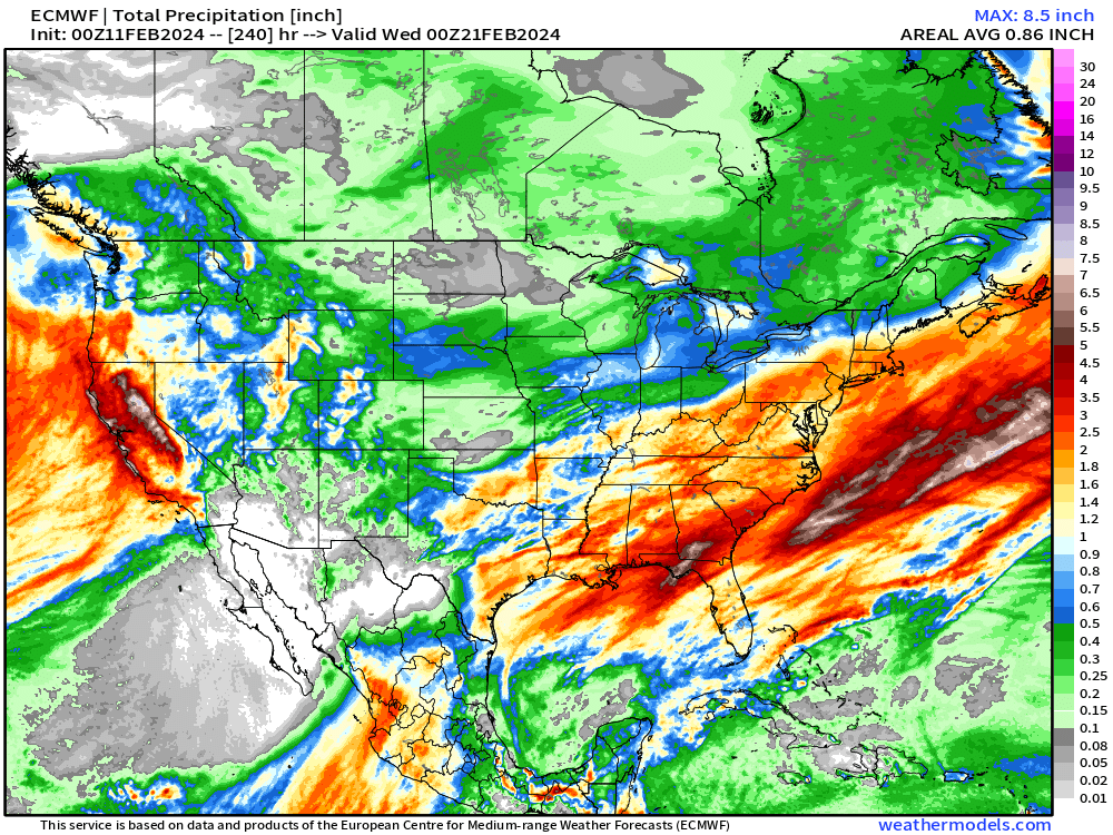
Looking down the pike at the next 10-days total from ECMWF 00z HRES and here is our pattern change to more wintry weather with colder temperatures typical of mid-February and plenty of moisture falling as snow.
It’s difficult to pinpoint the storm tracks past Day 5-6 when this additional snow is likely, but the Northeast really stands out with much more!

And, plenty of rainfall across California again with heavy mountain snows across the entire Rocky Mountain range. We’ve seen this winter load up on moisture from the Pacific and fling it across the Lower 48. Previously in February, there was a blocking ridge over Canada then kept the storm track along the subtropical jet in the southern U.S. but that broke down. Now we get intrusions of Arctic air and influence of the polar vortex.
We can see that pattern shift in the 850-hPa Temperature anomaly (1.5 kilometers above the surface). Winter sees dramatic anomalies in both directions with variability associated with weather systems e.g. troughs and ridges constantly progressing or retrograding through North America coming from the Pacific or Arctic.

And, we finally after several weeks have a legitimate “polar vortex” intrusion of much colder air in the Midwest and Northeast by next weekend. And with each of these troughs, if a surface low can phase properly, then we could get another winter storm or bomb cyclone development in the 7-10 day time frame e.g. next weekend somewhere across the Great Lakes to the Northeast. The ensembles have multiple avenues or opportunities.

15-Day EPS Mean Temperature Anomaly
Highly variable temperatures over the next 2-weeks dependent upon the upper-level pattern e.g. where the ridges and troughs line up. So, the ensemble mean is less informative with much smoothing wiping out this variability.
EPS 15-day Median Snowfall Accumulations

The median snowfall total for the next 15-days is very nice in New England for winter weather lovers. Looking at 12-20” instead of 0-inches, like we did at the end of Janauary.

And the huge snowfall totals across the Western U.S. continue!

The 15-day probability of 12” of snowfall is significant from central PA through Boston pushing 50-80%! That is a good signal as there is for another major winter storm to finish out February. Boston interquartile range is 12-18” for the next 15-days!
(Maps from weathermodels.com and weathertrader.com)
Multi-model and single multi-cycle cluster analysis coming to Weather Trader to better nail down the temperature anomaly and upper-level pattern during the next 5-15 days. Here’s an example of the last 3-cycles of the ECMWF ensembles with a domain over the CONUS. We can do this for Europe, Asia, South America, or any other domain with n=2 up to n=4 or 5 clusters. I find 3 to 4 clusters the best way to sort the ensembles. Subscribers will have access to these tools at no extra cost.

Thank you to my paying subscribers! Consider upgrading to a Yearly Plan if you find these updates valuable and wish to support my development at Weather Trader.
In addition, the products that you would typically see at AG2 (old WSI-trader) or other commodity weather services will be available for access. The goal is not to make another weather models site w/a catalogue of millions of updating images, rather provide value-added serves curated to specific verticals e.g. gardening, farming, energy, transportation, tourism.
Also, it allows me to provide (usually) interesting and valuable commentary on scientific topics on X. Feel free to say hello and follow on X/Twitter (@RyanMaue)