


February 10, 2024 Winter Storm Watch
Pattern shift to more wintry weather ahead
Weather Trader | Saturday Evening Update
Snowfall over the past 90-days has not been a complete bust for winter. The only problem is that it all melted east of the Rockies almost as fast as it fell.
Last 90-days:

Looking at February 2024: almost spotless east of the Rockies except for northern Maine.

However, there is a noticeable pattern shift with more cold air available for winter storms starting with the upcoming bomb cyclone that will cruise off the U.S. East Coast and mature/occlude over the NW Atlantic.
The ensemble median snowfall for the next 15-days (Thru Feb 25) shows plenty more snowfall for the Northeast U.S.
Individual ensembles have huge numbers while others are in the 12-18” range for the 2-weeks. That’s a wonderful mid-to-late February snowfall signal.
EPS 15-day Median Snowfall Accumulations

The bomb cyclone is baked in the oven and ready to go. The low will be in the 970s as it slips east of Cape Cod with heavy snow on the backside of the system. Winds will be gusty and heavy snow could mean blizzard conditions. The system is moving rather quickly and does not loop off the Northeast coast like so many other major systems in years past. So, we’re more in the 12-18” maximum snowfall for interior New England rather than 2-3 feet.
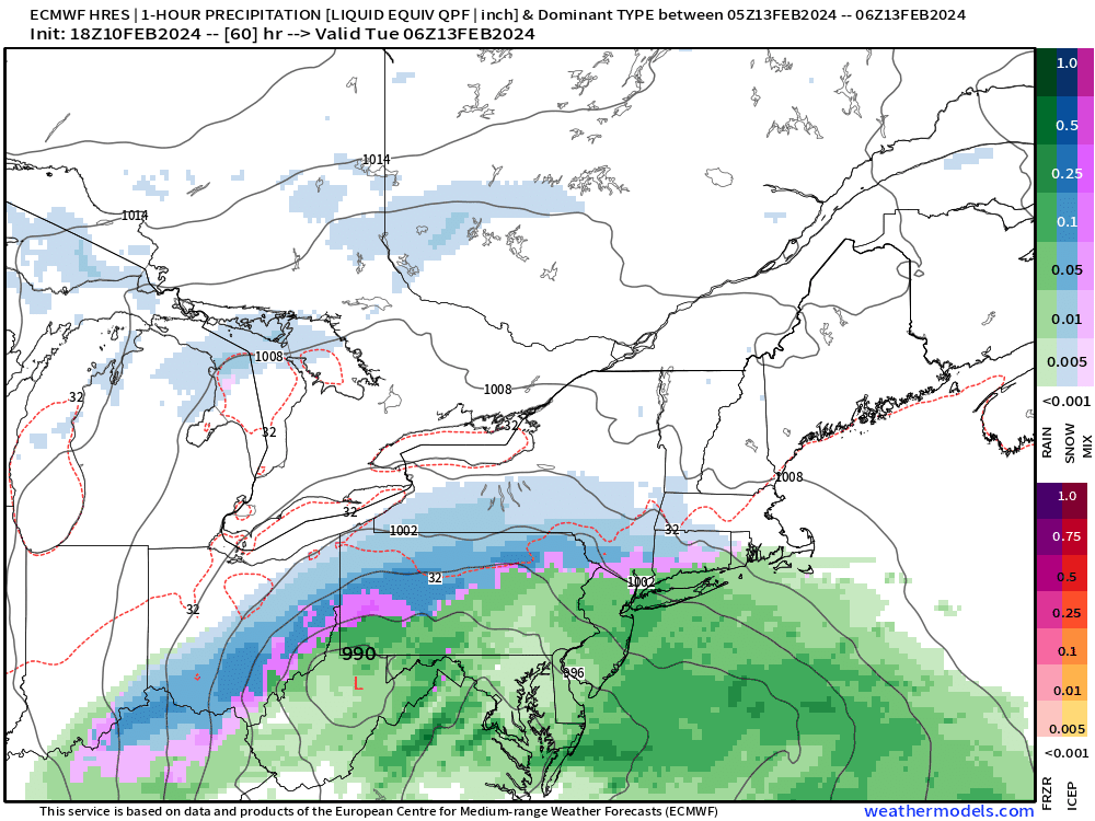
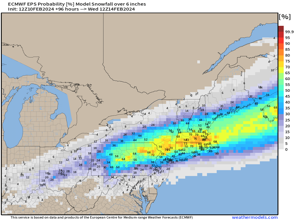
The probability of 6” of snowfall is significant from central PA through Boston.
The ECMWF HRES 12z is more to my liking as it has remained consistent with the QPF and snowfall p-type along the stripe from Ohio Valley into New England.
NYC is 3-6” and Boston is 12-18”
We’ll see how that forecast looks tomorrow.

As I mentioned, the Arctic polar vortex is joining us in the Western Hemisphere with colder air forming over Canada and surging into the Lower 48 in brief spurts with storm systems or more of these bowling ball mobile troughs.
At Day 5, the trough off the East Coast from our Bomb Cyclone is apparent matched up with block over Alaska.

By Day 12 in the EPS Control, there is a powerful Nor’easter again but this time with assistance from the tropopause Polar Vortex to really deepen the low and trough. So, looking into the final week of February, the overall upper-level pattern looks quite favorable for another major winter storm somewhere from the Great Lakes to the Northeast.

Lower 48 Temperatures
Sunday Highs | February 11, 2024
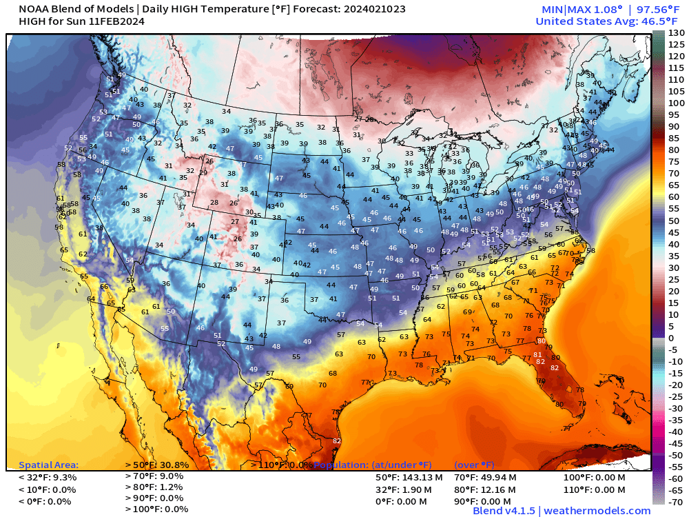

Feels good to just look at the orange and red in Florida in the 80s. But the rest of the Lower 48 is rather mild yet for mid-February. No complaints shall be registered.
Next 15-days Daily Temperature Anomaly


The 5-day chunks do show some colder than normal air but nothing like what we saw in early January. I’d call this seasonable as we turn the corner in February.
7-day Total Precipitation from WPC

Moisture returns to California by next weekend.
The heavy rain ahead of the developing winter storm from Texas to Southeast will add up to 2-3” over several states. Another very wet period.
(Maps from weathermodels.com and weathertrader.com)
Thank you to my paying subscribers! Consider upgrading to a Yearly Plan if you find these updates valuable and wish to support my development at Weather Trader.
In addition, the products that you would typically see at AG2 (old WSI-trader) or other commodity weather services will be available for access. The goal is not to make another weather models site w/a catalogue of millions of updating images, rather provide value-added serves curated to specific verticals e.g. gardening, farming, energy, transportation, tourism.
Also, it allows me to provide (usually) interesting and valuable commentary on scientific topics on X. Feel free to say hello and follow on X/Twitter (@RyanMaue)
Do we have to use nonsensical terminology like “bomb cyclone”?
Can’t we just call them storms, like the good old days? There is nothing particularly special about these storms, naming winter storms is just another method of increasing anxiety.
I heard on the news today here in canada that as many as 25% of our new pot users are showing up in emergency rooms with anxiety panic attacks, can’t we just calm down a bit?